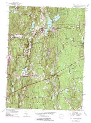
East Killingly Topo Map Connecticut
To zoom in, hover over the map of East Killingly
USGS Topo Quad 41071g7 - 1:24,000 scale
| Topo Map Name: | East Killingly |
| USGS Topo Quad ID: | 41071g7 |
| Print Size: | ca. 21 1/4" wide x 27" high |
| Southeast Coordinates: | 41.75° N latitude / 71.75° W longitude |
| Map Center Coordinates: | 41.8125° N latitude / 71.8125° W longitude |
| U.S. States: | CT, RI |
| Filename: | o41071g7.jpg |
| Download Map JPG Image: | East Killingly topo map 1:24,000 scale |
| Map Type: | Topographic |
| Topo Series: | 7.5´ |
| Map Scale: | 1:24,000 |
| Source of Map Images: | United States Geological Survey (USGS) |
| Alternate Map Versions: |
East Killingly CT 1955, updated 1956 Download PDF Buy paper map East Killingly CT 1955, updated 1960 Download PDF Buy paper map East Killingly CT 1955, updated 1969 Download PDF Buy paper map East Killingly CT 1955, updated 1972 Download PDF Buy paper map East Killingly CT 1955, updated 1977 Download PDF Buy paper map East Killingly CT 2012 Download PDF Buy paper map East Killingly CT 2015 Download PDF Buy paper map |
1:24,000 Topo Quads surrounding East Killingly
> Back to 41071e1 at 1:100,000 scale
> Back to 41070a1 at 1:250,000 scale
> Back to U.S. Topo Maps home
East Killingly topo map: Gazetteer
East Killingly: Dams
Acme Pond Dam elevation 175m 574′Chase Reservoir Dam elevation 134m 439′
Crystal Pond Dam elevation 110m 360′
Eddy Pray Reservoir Dam elevation 179m 587′
Furnace Pond Dam elevation 101m 331′
Killingly Pond Dam elevation 183m 600′
Lake Albert Dam elevation 212m 695′
Lower Ross Pond Dam elevation 110m 360′
Ross Management Area Pond Dam elevation 154m 505′
Smith Pond Dam elevation 169m 554′
Snake Meadow Pond Dam elevation 96m 314′
Talcott Reservoir Dike Number 2 elevation 203m 666′
Tetreault Pond Dam elevation 128m 419′
Whetstone Brook Dam elevation 132m 433′
East Killingly: Lakes
Acme Pond elevation 175m 574′Ross Pond elevation 110m 360′
Shippee Sawmill Pond elevation 170m 557′
Smith Pond elevation 169m 554′
Snake Meadow Pond elevation 96m 314′
Tetreault Pond elevation 113m 370′
Tremont Pond elevation 206m 675′
East Killingly: Parks
Killingly Pond State Park Reserve elevation 179m 587′Old Furnace State Park elevation 119m 390′
Squaw Rock State Park elevation 138m 452′
East Killingly: Populated Places
Acquidaneck (historical) elevation 101m 331′East Killingly elevation 183m 600′
Elliotville (historical) elevation 132m 433′
Foster elevation 216m 708′
Killingly Center elevation 103m 337′
North Foster elevation 168m 551′
South Killingly elevation 174m 570′
East Killingly: Post Offices
Ballouville Post Office elevation 105m 344′East Killingly Post Office elevation 161m 528′
East Killingly: Reservoirs
Alvia Chase Reservoir elevation 175m 574′Bog Meadow Reservoir elevation 171m 561′
Chase Reservoir elevation 134m 439′
Clark Pond elevation 158m 518′
Crystal Pond elevation 110m 360′
Eddy Pray Reservoir elevation 179m 587′
Furnace Pond elevation 101m 331′
Killingly Pond elevation 183m 600′
Killingly Pond elevation 179m 587′
Lake Albert elevation 212m 695′
Lower Ross Pond elevation 110m 360′
Middle Reservoir elevation 173m 567′
Ross Management Area Pond elevation 154m 505′
Whetstone Brook Reservoir elevation 132m 433′
East Killingly: Streams
Half Hill Brook elevation 100m 328′Huntington Brook elevation 179m 587′
Mashentuck Brook elevation 105m 344′
Norton Brook elevation 122m 400′
Phillips Brook elevation 119m 390′
Rounds Brook elevation 152m 498′
Salisbury Brook elevation 155m 508′
Slater Brook elevation 116m 380′
Tennant Brook elevation 104m 341′
Titus Brook elevation 141m 462′
Warren Brook elevation 109m 357′
East Killingly: Summits
Alva Pond Hill elevation 197m 646′Bear Hill elevation 215m 705′
Bear Hill elevation 179m 587′
Breakneck Hill elevation 195m 639′
Chestnut Hill elevation 223m 731′
Cook Hill elevation 172m 564′
Cucumber Hill elevation 195m 639′
Half Hill elevation 159m 521′
Jerimoth Hill elevation 256m 839′
Mashentuck Mountain elevation 179m 587′
Mount Hygeia elevation 224m 734′
Slater Hill elevation 199m 652′
Squaw Rock elevation 167m 547′
East Killingly: Swamps
Balm of Gilead Swamp elevation 243m 797′Honeypot Swamp elevation 215m 705′
Moran Swamp elevation 238m 780′
Mowry Meadow elevation 184m 603′
East Killingly digital topo map on disk
Buy this East Killingly topo map showing relief, roads, GPS coordinates and other geographical features, as a high-resolution digital map file on DVD:
Maine, New Hampshire, Rhode Island & Eastern Massachusetts
Buy digital topo maps: Maine, New Hampshire, Rhode Island & Eastern Massachusetts


