Taunton Topo Map Massachusetts
To zoom in, hover over the map of Taunton
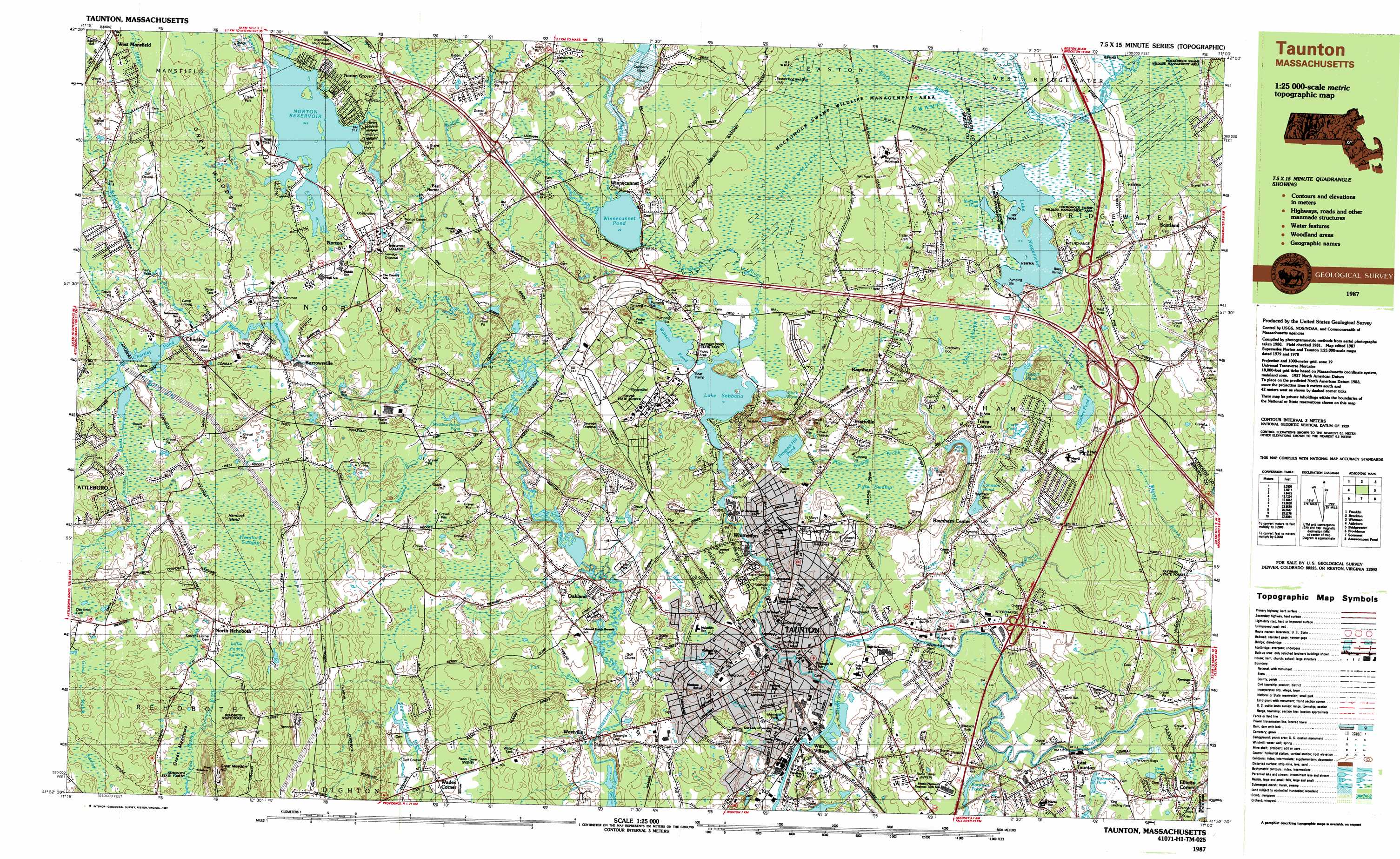
USGS Topo Quad 41071h1 - 1:25,000 scale
| Topo Map Name: | Taunton |
| USGS Topo Quad ID: | 41071h1 |
| Print Size: | ca. 39" wide x 24" high |
| Southeast Coordinates: | 41.875° N latitude / 71° W longitude |
| Map Center Coordinates: | 41.9375° N latitude / 71.125° W longitude |
| U.S. State: | MA |
| Filename: | k41071h1.jpg |
| Download Map JPG Image: | Taunton topo map 1:25,000 scale |
| Map Type: | Topographic |
| Topo Series: | 7.5´x15´ |
| Map Scale: | 1:25,000 |
| Source of Map Images: | United States Geological Survey (USGS) |
| Alternate Map Versions: |
Taunton MA 1987, updated 1987 Download PDF Buy paper map Taunton MA 1987, updated 1987 Download PDF Buy paper map |
1:24,000 Topo Quads surrounding Taunton
Medfield |
Blue Hills |
Cohasset |
||
Wrentham |
Brockton |
Whitman |
Hanover |
|
Attleboro |
Taunton |
Bridgewater |
Plympton |
|
East Providence |
Assonet |
Assawompset Pond |
Snipatuit Pond |
|
Bristol |
Fall River East |
New Bedford North |
Marion |
> Back to 41071e1 at 1:100,000 scale
> Back to 41070a1 at 1:250,000 scale
> Back to U.S. Topo Maps home
Taunton topo map: Gazetteer
Taunton: Airports
George H Crosman USAR Center Heliport elevation 20m 65′Millipore Heliport elevation 27m 88′
Taunton: Crossings
Interchange Thirty-one elevation 24m 78′Interchange Thirty-two elevation 11m 36′
Taunton: Dams
Barstows Pond Dam elevation 9m 29′Chartley Pond Dam elevation 30m 98′
Johnson Pond Dam elevation 11m 36′
Kings Pond Dam elevation 14m 45′
Meadowbrook Pond Dam elevation 22m 72′
Mill River Dam elevation 15m 49′
Moreys Bridge Dam elevation 17m 55′
Norton Reservoir Dam elevation 31m 101′
Prospect Hill Reservoir Dam elevation 52m 170′
Segreganset River Dam elevation 28m 91′
Taunton: Forests
Rehoboth State Forest elevation 47m 154′Taunton: Islands
Hemlock Island elevation 36m 118′Taunton: Lakes
Barrowsville Pond elevation 30m 98′Black Pond elevation 22m 72′
Deep Pond elevation 9m 29′
Gushee Pond elevation 19m 62′
Hewitt Pond elevation 16m 52′
Jones Pond elevation 12m 39′
Kings Pond elevation 10m 32′
Lake Nippenicket elevation 17m 55′
Nunkets Pond elevation 18m 59′
Richmond Pond elevation 5m 16′
Sheppards Factory Pond elevation 12m 39′
Tracy Pond elevation 12m 39′
Watson Pond elevation 19m 62′
Wilbur Pond elevation 15m 49′
Willis Pond elevation 19m 62′
Winnecunnet Pond elevation 20m 65′
Taunton: Parks
Hopewell Park elevation 9m 29′Memorial Park elevation 8m 26′
Taunton Common elevation 9m 29′
Watson Pond State Park elevation 19m 62′
Taunton: Populated Places
Barrowsville elevation 28m 91′Britanniaville elevation 23m 75′
Centre Mills elevation 27m 88′
Chartley elevation 36m 118′
Copper Works elevation 28m 91′
Cranes Station elevation 27m 88′
East Norton elevation 24m 78′
East Taunton elevation 6m 19′
Judson elevation 9m 29′
Meadow Brook elevation 21m 68′
North Rehoboth elevation 39m 127′
Norton elevation 32m 104′
Norton Furnace (historical) elevation 20m 65′
Norton Grove elevation 33m 108′
Oakland elevation 13m 42′
Prattville elevation 31m 101′
Raynham elevation 24m 78′
Raynham Center elevation 12m 39′
Scotland elevation 30m 98′
Scotland Estates elevation 26m 85′
Taunton elevation 5m 16′
Tracy Corner elevation 19m 62′
Wades Corner elevation 30m 98′
Weir Village elevation 10m 32′
West Mansfield elevation 44m 144′
Westville elevation 11m 36′
Whittenton elevation 24m 78′
Whittenton Junction elevation 20m 65′
Winnecunnet elevation 21m 68′
Taunton: Post Offices
East Taunton Post Office elevation 6m 19′Norton Post Office elevation 32m 104′
Raynham Post Office elevation 24m 78′
Scotland Post Office (historical) elevation 37m 121′
Taunton Post Office elevation 8m 26′
Taunton: Reservoirs
Barstows Pond elevation 9m 29′Chartley Pond elevation 30m 98′
Forge River Reservoir elevation 14m 45′
Johnson Pond elevation 11m 36′
Lake Sabbatia elevation 17m 55′
Meadow Brook Pond elevation 20m 65′
Mill River Reservoir elevation 15m 49′
Norton Reservoir elevation 32m 104′
Prospect Hill Pond elevation 52m 170′
Segreganset River Reservoir elevation 28m 91′
Taunton: Streams
Birch Brook elevation 23m 75′Black Brook elevation 18m 59′
Canoe River elevation 20m 65′
Chartley Brook elevation 29m 95′
Cobb Brook elevation 3m 9′
Cotley River elevation 2m 6′
Dam Lot Brook elevation 2m 6′
Damlot Brook elevation 5m 16′
Fall Brook elevation 11m 36′
Forge River elevation 2m 6′
Furnance Brook elevation 2m 6′
Goose Branch elevation 24m 78′
Hockomock River elevation 18m 59′
Hodges Brook elevation 32m 104′
Meadow Brook elevation 17m 55′
Mill River elevation 2m 6′
Mulberry Meadow Brook elevation 20m 65′
Pine Swamp Brook elevation 6m 19′
Rumford River elevation 18m 59′
Snake River elevation 19m 62′
Wading River elevation 18m 59′
Taunton: Summits
Great Meadow Hill elevation 78m 255′Prospect Hill elevation 59m 193′
Squawbetty Hill elevation 8m 26′
Taunton: Swamps
Crapo Bog elevation 15m 49′Dead Swamp elevation 21m 68′
Hemlock Swamp elevation 36m 118′
Hockomock Swamp elevation 18m 59′
Pine Swamp elevation 16m 52′
Titicut Swamp elevation 18m 59′
Taunton digital topo map on disk
Buy this Taunton topo map showing relief, roads, GPS coordinates and other geographical features, as a high-resolution digital map file on DVD:
Maine, New Hampshire, Rhode Island & Eastern Massachusetts
Buy digital topo maps: Maine, New Hampshire, Rhode Island & Eastern Massachusetts