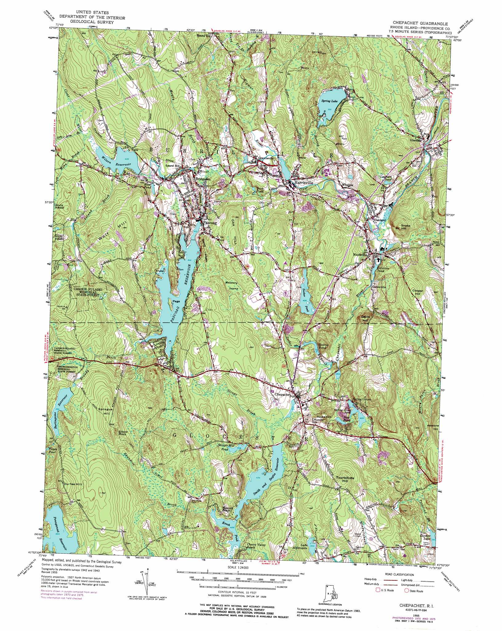
Chepachet Topo Map Rhode Island
To zoom in, hover over the map of Chepachet
USGS Topo Quad 41071h6 - 1:24,000 scale
| Topo Map Name: | Chepachet |
| USGS Topo Quad ID: | 41071h6 |
| Print Size: | ca. 21 1/4" wide x 27" high |
| Southeast Coordinates: | 41.875° N latitude / 71.625° W longitude |
| Map Center Coordinates: | 41.9375° N latitude / 71.6875° W longitude |
| U.S. State: | RI |
| Filename: | o41071h6.jpg |
| Download Map JPG Image: | Chepachet topo map 1:24,000 scale |
| Map Type: | Topographic |
| Topo Series: | 7.5´ |
| Map Scale: | 1:24,000 |
| Source of Map Images: | United States Geological Survey (USGS) |
| Alternate Map Versions: |
Chepachet RI 1955, updated 1957 Download PDF Buy paper map Chepachet RI 1955, updated 1966 Download PDF Buy paper map Chepachet RI 1955, updated 1972 Download PDF Buy paper map Chepachet RI 1955, updated 1976 Download PDF Buy paper map Chepachet RI 1955, updated 1988 Download PDF Buy paper map Chepachet RI 1999, updated 2000 Download PDF Buy paper map Chepachet RI 2012 Download PDF Buy paper map Chepachet RI 2015 Download PDF Buy paper map |
1:24,000 Topo Quads surrounding Chepachet
Worcester South |
Milford |
|||
Oxford |
Blackstone |
|||
Putnam |
Thompson |
Chepachet |
Georgiaville |
|
Danielson |
East Killingly |
Clayville |
North Scituate |
|
Plainfield |
Oneco |
Coventry Center |
Crompton |
East Greenwich |
> Back to 41071e1 at 1:100,000 scale
> Back to 41070a1 at 1:250,000 scale
> Back to U.S. Topo Maps home
Chepachet topo map: Gazetteer
Chepachet: Beaches
Flynns Beach elevation 120m 393′Gillerans Pond Beach elevation 134m 439′
Spring Lake Beach elevation 119m 390′
YWCA Beach elevation 121m 396′
Chepachet: Benches
Garvy Ledges elevation 163m 534′Chepachet: Dams
Aldersgate Lake Dam elevation 117m 383′Burlingame Reservoir Upper Dam elevation 183m 600′
Coomer Lake Dam elevation 113m 370′
Harrisville Pond Dam elevation 105m 344′
Mower Pond Dam elevation 131m 429′
Oakland Pond Dam elevation 100m 328′
Pascoag Reservoir Upper Dam elevation 131m 429′
Smith and Sayles Reservoir Dam elevation 129m 423′
Spring Lake Dam elevation 120m 393′
Sucker Pond Dam elevation 144m 472′
Wilson Reservoir Dam elevation 134m 439′
Chepachet: Islands
Page Island elevation 136m 446′Snake Island elevation 137m 449′
Chepachet: Lakes
Duck Pond elevation 127m 416′Lapham Pond elevation 109m 357′
Spring Grove Pond elevation 135m 442′
Spring Lake elevation 120m 393′
Tepee Pond elevation 189m 620′
Chepachet: Parks
Durfee Hill Management Area elevation 242m 793′Harrisville Historic District elevation 112m 367′
Heritage Park elevation 133m 436′
Pascoag Race Track (historical) elevation 134m 439′
Chepachet: Pillars
Elbow Rock elevation 208m 682′Chepachet: Populated Places
Bridgeton elevation 118m 387′Chepachet elevation 131m 429′
Gazzaville elevation 114m 374′
Glendale elevation 95m 311′
Graniteville elevation 103m 337′
Harrisville elevation 99m 324′
Huntsville elevation 131m 429′
Huntsville (historical) elevation 136m 446′
Laurel Hill elevation 122m 400′
Mapleville elevation 115m 377′
Oakland elevation 96m 314′
Pascoag elevation 130m 426′
Round Top elevation 123m 403′
Spring Grove elevation 137m 449′
Wescott Beach elevation 136m 446′
Whipple elevation 102m 334′
Chepachet: Post Offices
Chepachet Post Office elevation 130m 426′Harrisville Post Office elevation 107m 351′
Pascoag Post Office elevation 132m 433′
Chepachet: Reservoirs
Aldersgate Lake elevation 117m 383′Branch River elevation 100m 328′
Burlingame Reservoir elevation 183m 600′
Coomer Lake elevation 113m 370′
Gilleran Pond elevation 114m 374′
Harrisville Mill Pond elevation 101m 331′
Keech Pond elevation 130m 426′
Lake Aldersgate elevation 166m 544′
New Pond elevation 133m 436′
Pascoag Reservoir elevation 131m 429′
Ponaganset Reservoir elevation 196m 643′
Ross Pond elevation 136m 446′
Shingle Mill Pond elevation 141m 462′
Smith and Sayles Reservoir elevation 129m 423′
Spring Grove Pond elevation 131m 429′
Steeres Pond elevation 112m 367′
Sucker Pond elevation 144m 472′
Wilson Reservoir elevation 134m 439′
Chepachet: Streams
Brandy Brook elevation 132m 433′Chepachet River elevation 95m 311′
Chockalog River elevation 112m 367′
Chockalog River elevation 116m 380′
Clear River elevation 95m 311′
Dry Arm Brook elevation 143m 469′
Herring Brook elevation 95m 311′
Iron Mine Brook elevation 142m 465′
Leland Brook elevation 134m 439′
Mosquitohawk Brook elevation 207m 679′
Mowry Brook elevation 112m 367′
Nipmuc River elevation 101m 331′
Pascoag River elevation 112m 367′
Round Top Brook elevation 116m 380′
Round Top Brook elevation 112m 367′
Saunders Brook elevation 131m 429′
Stingo Brook elevation 133m 436′
Sucker Brook elevation 107m 351′
Tucker Brook elevation 88m 288′
Chepachet: Summits
Acote Hill elevation 149m 488′Cooper Hill elevation 170m 557′
Durfee Hill elevation 244m 800′
Gazza Hill elevation 143m 469′
Oak Hill elevation 168m 551′
Snake Hill elevation 160m 524′
Sprague Hill elevation 217m 711′
Tourtellotte Hill elevation 213m 698′
Wolf Hill elevation 204m 669′
Chepachet: Swamps
Malavary Swamp elevation 140m 459′Chepachet: Trails
Ross Trail elevation 168m 551′Chepachet digital topo map on disk
Buy this Chepachet topo map showing relief, roads, GPS coordinates and other geographical features, as a high-resolution digital map file on DVD:
Maine, New Hampshire, Rhode Island & Eastern Massachusetts
Buy digital topo maps: Maine, New Hampshire, Rhode Island & Eastern Massachusetts