Thompson Topo Map Connecticut
To zoom in, hover over the map of Thompson
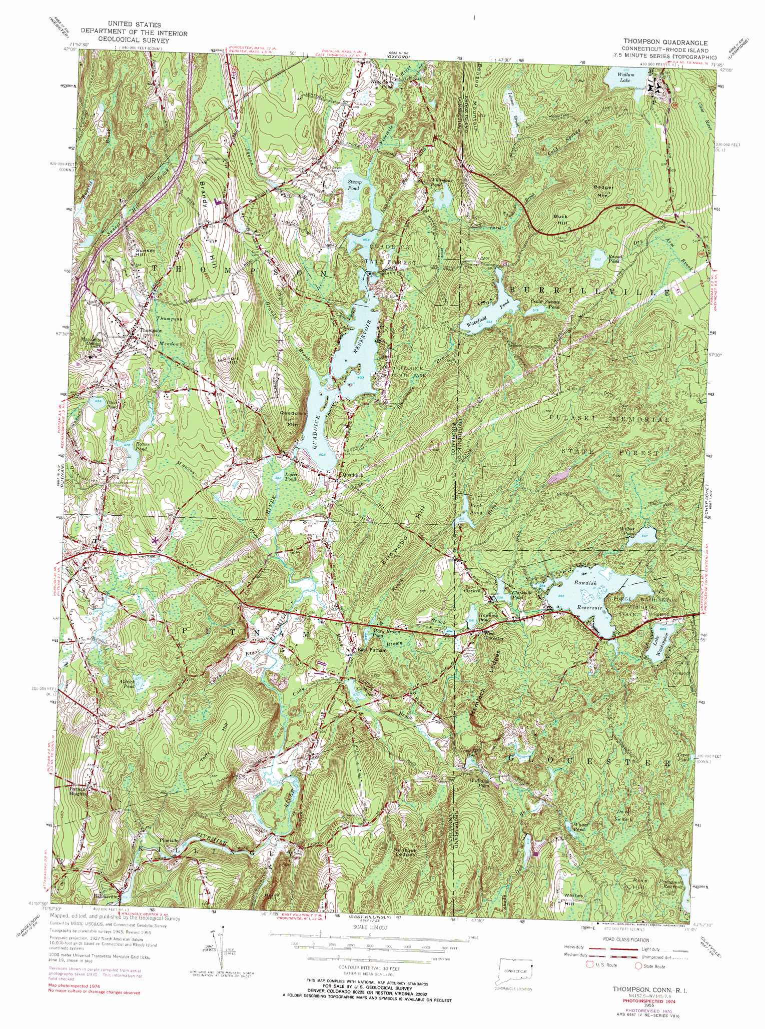
USGS Topo Quad 41071h7 - 1:24,000 scale
| Topo Map Name: | Thompson |
| USGS Topo Quad ID: | 41071h7 |
| Print Size: | ca. 21 1/4" wide x 27" high |
| Southeast Coordinates: | 41.875° N latitude / 71.75° W longitude |
| Map Center Coordinates: | 41.9375° N latitude / 71.8125° W longitude |
| U.S. States: | CT, RI |
| Filename: | o41071h7.jpg |
| Download Map JPG Image: | Thompson topo map 1:24,000 scale |
| Map Type: | Topographic |
| Topo Series: | 7.5´ |
| Map Scale: | 1:24,000 |
| Source of Map Images: | United States Geological Survey (USGS) |
| Alternate Map Versions: |
Thompson CT 1955, updated 1957 Download PDF Buy paper map Thompson CT 1955, updated 1983 Download PDF Buy paper map Thompson CT 2012 Download PDF Buy paper map Thompson CT 2015 Download PDF Buy paper map |
1:24,000 Topo Quads surrounding Thompson
East Brookfield |
Worcester South |
Milford |
||
Southbridge |
Oxford |
Blackstone |
||
Eastford |
Putnam |
Thompson |
Chepachet |
Georgiaville |
Hampton |
Danielson |
East Killingly |
Clayville |
North Scituate |
Scotland |
Plainfield |
Oneco |
Coventry Center |
Crompton |
> Back to 41071e1 at 1:100,000 scale
> Back to 41070a1 at 1:250,000 scale
> Back to U.S. Topo Maps home
Thompson topo map: Gazetteer
Thompson: Airports
Quaddick Lake Seaplane Base elevation 123m 403′Yankee Airstrip elevation 188m 616′
Thompson: Benches
Hemlock Ledges elevation 203m 666′Kentuck Ledges elevation 200m 656′
Thompson: Dams
Ballouville Pond Dam elevation 99m 324′Bowdish Reservoir Dam elevation 173m 567′
Buck Hill Pond Dam elevation 202m 662′
Cady Pond Dam elevation 128m 419′
Clarkville Pond Dam elevation 162m 531′
Hawkins Pond Dam elevation 157m 515′
Lake Washington Dam elevation 185m 606′
Old Daniels Dam elevation 117m 383′
Peck Pond Dam elevation 159m 521′
Quaddick Reservoir Dam elevation 131m 429′
Reams Pond Dam elevation 156m 511′
Wakefield Pond Dam elevation 170m 557′
Wallum Lake Dam elevation 178m 583′
Whitmans Pond Dam elevation 151m 495′
Wilbur Pond Dam elevation 185m 606′
Thompson: Forests
George Washington Memorial State Forest elevation 173m 567′Quaddick State Forest elevation 148m 485′
Thompson: Lakes
Aldrich Pond elevation 145m 475′Cady Pond elevation 128m 419′
Cedar Swamp Pond elevation 176m 577′
Duck Pond elevation 139m 456′
Grist Mill Pond elevation 145m 475′
Kingsbury Pond elevation 134m 439′
Lake Washington elevation 184m 603′
Lower Pond elevation 119m 390′
Peck Pond elevation 159m 521′
Reams Pond elevation 146m 479′
Round Pond elevation 199m 652′
Stump Pond elevation 123m 403′
Wakefield Pond elevation 170m 557′
Whites Pond elevation 195m 639′
Whitmans Pond elevation 151m 495′
Wilbur Pond elevation 185m 606′
Williams Pond elevation 156m 511′
Thompson: Parks
Casimir Pulaski Memorial State Park elevation 217m 711′Finberg Field elevation 203m 666′
Quaddick State Park elevation 138m 452′
Thompson Green elevation 182m 597′
Thompson: Populated Places
Ballouville elevation 98m 321′Clarkville elevation 164m 538′
East Putnam elevation 140m 459′
Pineville elevation 111m 364′
Putnam Heights elevation 167m 547′
Quaddick elevation 136m 446′
Thompson elevation 181m 593′
Wallum Lake (historical) elevation 175m 574′
West Glocester elevation 167m 547′
Thompson: Post Offices
Thompson Post Office elevation 182m 597′Thompson: Reservoirs
Ballouville Pond elevation 99m 324′Bowdish Reservoir elevation 173m 567′
Buck Hill Pond elevation 202m 662′
Clarkville Pond elevation 162m 531′
Hawkins Pond elevation 157m 515′
Lake Washington elevation 185m 606′
Mary Brown Pond elevation 142m 465′
Peck Pond elevation 159m 521′
Quaddick Reservoir elevation 123m 403′
Reams Pond elevation 156m 511′
Wakefield Pond elevation 169m 554′
Wallum Lake elevation 178m 583′
Wilbur Pond elevation 189m 620′
Thompson: Springs
Boiling Spring elevation 192m 629′Thompson: Streams
Blackmore Brook elevation 130m 426′Brandy Brook elevation 133m 436′
Cady Brook elevation 116m 380′
Cold Spring Brook elevation 168m 551′
Croff Farm Brook elevation 151m 495′
Goat Rock Brook elevation 175m 574′
Janson Brook elevation 123m 403′
Keach Brook elevation 143m 469′
Leeson Brook elevation 175m 574′
Mary Brown Brook elevation 114m 374′
Munson Brook elevation 122m 400′
Paquantuck Brook elevation 202m 662′
Robbins Brook elevation 124m 406′
Shady Oak Brook elevation 145m 475′
Shady Oak Schoolhouse Brook elevation 132m 433′
Teft Brook elevation 126m 413′
Torry Brook elevation 116m 380′
Thompson: Summits
Badger Mountain elevation 221m 725′Benson Mountain elevation 226m 741′
Brandy Hill elevation 196m 643′
Buck Hill elevation 208m 682′
Elmwood Hill elevation 200m 656′
Fort Hill elevation 198m 649′
Horse Hill elevation 165m 541′
Pine Hill elevation 235m 770′
Quaddick Mountain elevation 180m 590′
Rattlesnake Hill elevation 172m 564′
Sunset Hill elevation 173m 567′
Thompson Hill elevation 181m 593′
Torry Hill elevation 191m 626′
Whites Hill elevation 240m 787′
Thompson: Swamps
Dark Swamp elevation 204m 669′Thompson Meadows elevation 164m 538′
Thompson: Trails
Border Trail elevation 180m 590′Munyan Trail elevation 214m 702′
Walkabout Trail elevation 191m 626′
Thompson: Woods
Buck Hill elevation 204m 669′Thompson digital topo map on disk
Buy this Thompson topo map showing relief, roads, GPS coordinates and other geographical features, as a high-resolution digital map file on DVD:
Maine, New Hampshire, Rhode Island & Eastern Massachusetts
Buy digital topo maps: Maine, New Hampshire, Rhode Island & Eastern Massachusetts