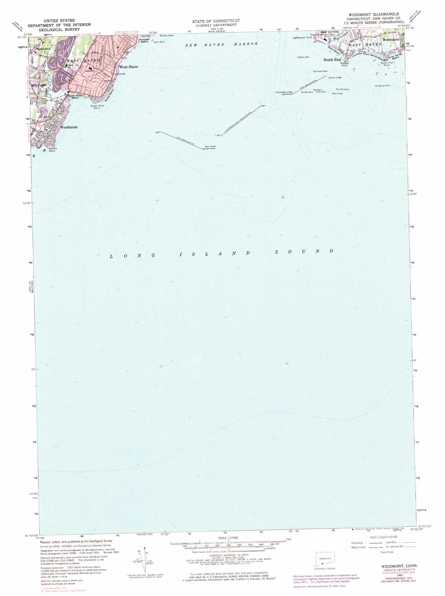
Woodmont Topo Map Connecticut
To zoom in, hover over the map of Woodmont
USGS Topo Quad 41072b8 - 1:24,000 scale
| Topo Map Name: | Woodmont |
| USGS Topo Quad ID: | 41072b8 |
| Print Size: | ca. 21 1/4" wide x 27" high |
| Southeast Coordinates: | 41.125° N latitude / 72.875° W longitude |
| Map Center Coordinates: | 41.1875° N latitude / 72.9375° W longitude |
| U.S. State: | CT |
| Filename: | o41072b8.jpg |
| Download Map JPG Image: | Woodmont topo map 1:24,000 scale |
| Map Type: | Topographic |
| Topo Series: | 7.5´ |
| Map Scale: | 1:24,000 |
| Source of Map Images: | United States Geological Survey (USGS) |
| Alternate Map Versions: |
Woodmont CT 1951, updated 1959 Download PDF Buy paper map Woodmont CT 1960 Download PDF Buy paper map Woodmont CT 1960, updated 1962 Download PDF Buy paper map Woodmont CT 1960, updated 1973 Download PDF Buy paper map Woodmont CT 2012 Download PDF Buy paper map Woodmont CT 2015 Download PDF Buy paper map |
1:24,000 Topo Quads surrounding Woodmont
Southbury |
Naugatuck |
Mount Carmel |
Wallingford |
Durham |
Long Hill |
Ansonia |
New Haven |
Branford |
Guilford |
Bridgeport |
Milford |
Woodmont |
||
Saint James |
Port Jefferson |
Middle Island |
Wading River |
Riverhead |
> Back to 41072a1 at 1:100,000 scale
> Back to 41072a1 at 1:250,000 scale
> Back to U.S. Topo Maps home
Woodmont topo map: Gazetteer
Woodmont: Airports
West Haven Airport (historical) elevation 12m 39′Woodmont: Bars
Adams Fall elevation 0m 0′Old Head Reef elevation 0m 0′
Quixes Ledge elevation 0m 0′
South West Ledge elevation 0m 0′
Woodmont: Beaches
Oyster River Beach elevation 2m 6′Prospect Beach elevation 0m 0′
Rocky Beach elevation 2m 6′
Shell Beach elevation 0m 0′
Silver Sands Beach elevation 4m 13′
West Silver Sands Beach elevation 5m 16′
Woodmont: Capes
Lighthouse Point elevation 3m 9′Merwin Point elevation 2m 6′
Morgan Point elevation 7m 22′
Oyster River Point elevation 5m 16′
South End Point elevation 3m 9′
Woodmont: Channels
New Haven Harbor Entrance Channel elevation 0m 0′Woodmont: Dams
East Breakwater elevation 0m 0′Lake Dawson Dam elevation 0m 0′
Luddington Rock Breakwater elevation 0m 0′
West Breakwater elevation 0m 0′
Woodmont: Islands
Big Boil elevation 0m 0′Dick Rock elevation 0m 0′
Mary Rock elevation 0m 0′
Middle Rock elevation 0m 0′
Round Rock elevation 0m 0′
Savin Rock elevation 0m 0′
The Chimneys elevation 0m 0′
Twin Rocks elevation 0m 0′
Woodmont: Parks
Colonial Park (historical) elevation 30m 98′Hawley Avenue Playground elevation 10m 32′
Woodmont: Populated Places
South End elevation 7m 22′West Shore elevation 7m 22′
Woodmont elevation 12m 39′
Woodmont: Post Offices
Woodmont Station Post Office elevation 10m 32′Woodmont: Streams
Morris Creek elevation 1m 3′Oyster River elevation 1m 3′
Woodmont: Summits
Jones Hill elevation 44m 144′Woodmont digital topo map on disk
Buy this Woodmont topo map showing relief, roads, GPS coordinates and other geographical features, as a high-resolution digital map file on DVD:
New York, Vermont, Connecticut & Western Massachusetts
Buy digital topo maps: New York, Vermont, Connecticut & Western Massachusetts