Clinton Topo Map Connecticut
To zoom in, hover over the map of Clinton
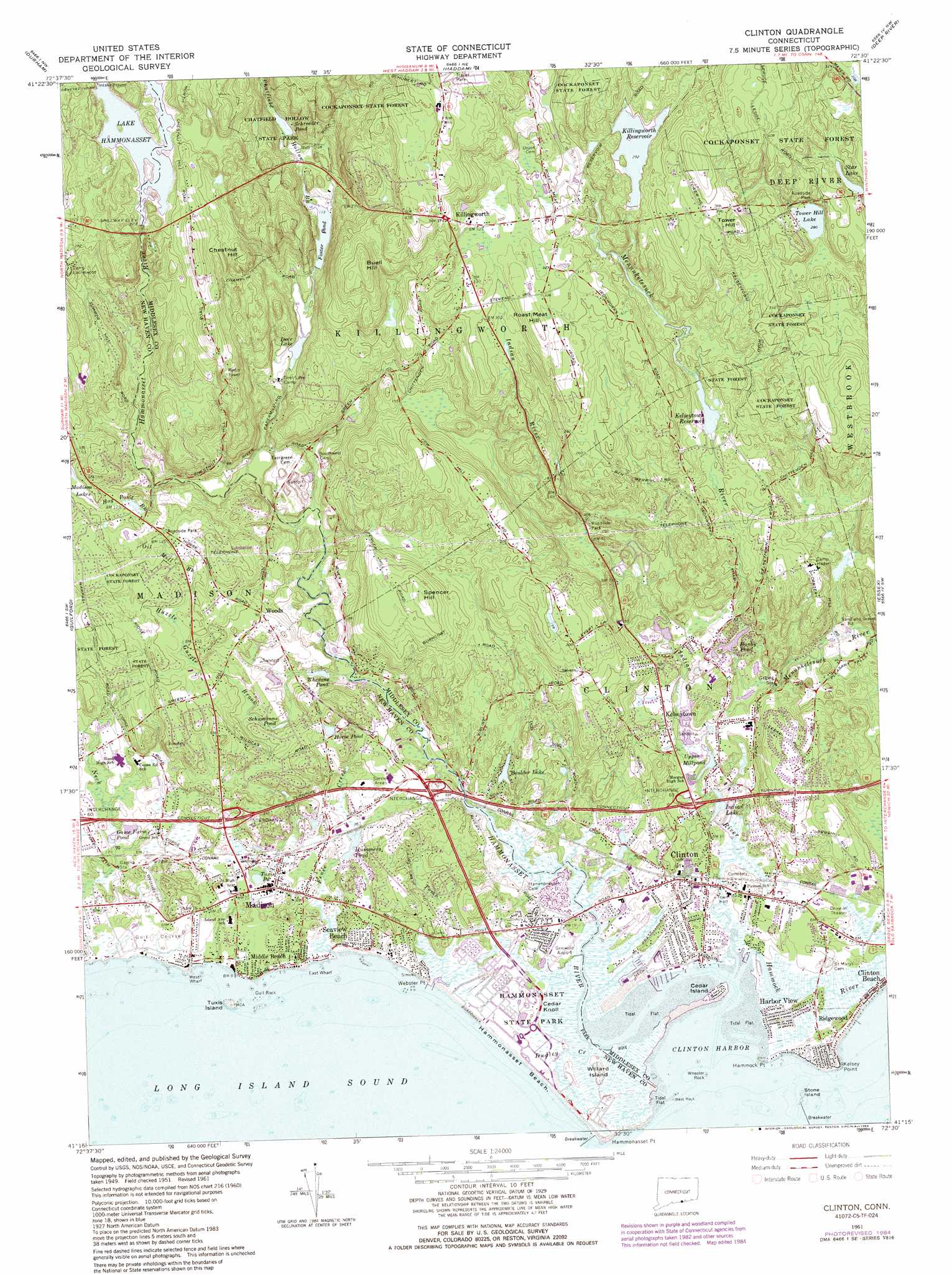
USGS Topo Quad 41072c5 - 1:24,000 scale
| Topo Map Name: | Clinton |
| USGS Topo Quad ID: | 41072c5 |
| Print Size: | ca. 21 1/4" wide x 27" high |
| Southeast Coordinates: | 41.25° N latitude / 72.5° W longitude |
| Map Center Coordinates: | 41.3125° N latitude / 72.5625° W longitude |
| U.S. State: | CT |
| Filename: | o41072c5.jpg |
| Download Map JPG Image: | Clinton topo map 1:24,000 scale |
| Map Type: | Topographic |
| Topo Series: | 7.5´ |
| Map Scale: | 1:24,000 |
| Source of Map Images: | United States Geological Survey (USGS) |
| Alternate Map Versions: |
Clinton CT 1951, updated 1959 Download PDF Buy paper map Clinton CT 1961, updated 1964 Download PDF Buy paper map Clinton CT 1961, updated 1971 Download PDF Buy paper map Clinton CT 1961, updated 1984 Download PDF Buy paper map Clinton CT 1961, updated 1984 Download PDF Buy paper map Clinton CT 2012 Download PDF Buy paper map Clinton CT 2015 Download PDF Buy paper map |
1:24,000 Topo Quads surrounding Clinton
Meriden |
Middletown |
Middle Haddam |
Moodus |
Colchester |
Wallingford |
Durham |
Haddam |
Deep River |
Hamburg |
Branford |
Guilford |
Clinton |
Essex |
Old Lyme |
Orient |
||||
Mattituck Hills |
Southold |
Greenport |
> Back to 41072a1 at 1:100,000 scale
> Back to 41072a1 at 1:250,000 scale
> Back to U.S. Topo Maps home
Clinton topo map: Gazetteer
Clinton: Airports
Griswold Airport elevation 5m 16′Clinton: Bars
East Ledge elevation 0m 0′Madison Reef elevation 0m 0′
Stone Island Reef elevation 0m 0′
Clinton: Bays
Clinton Harbor elevation 0m 0′Clinton: Beaches
Clinton Town Beach elevation 3m 9′Hammonasset Beach elevation 0m 0′
Clinton: Bridges
Ninevah Bridge elevation 86m 282′Clinton: Capes
Hammock Point elevation 2m 6′Kelsey Point elevation 0m 0′
Sandy Point (historical) elevation 1m 3′
Webster Point elevation 2m 6′
Clinton: Channels
Dardanells elevation 1m 3′Clinton: Crossings
Interchange 61 elevation 27m 88′Interchange 62 elevation 16m 52′
Interchange 63 elevation 17m 55′
Interchange Sixty elevation 7m 22′
Clinton: Dams
Boulder Lake Dam elevation 17m 55′Clinton Breakwater elevation 0m 0′
Deer Lake Dam elevation 38m 124′
Fosters Pond Dam elevation 34m 111′
Hammonasset Reservoir Dam elevation 83m 272′
Indian Lake Dam elevation 3m 9′
Kelseytown Reservoir Dam elevation 53m 173′
Killingworth Reservoir Dam elevation 88m 288′
Lockwood Lake Dam elevation 21m 68′
Schreeder Pond Dam elevation 56m 183′
Tower Hill Lake Dam elevation 85m 278′
Upper Millpond Dam elevation 10m 32′
Clinton: Islands
Cedar Island elevation 1m 3′Gull Rock elevation 0m 0′
Stone Island elevation 0m 0′
Tuxis Island elevation 0m 0′
West Rock elevation 0m 0′
Wheeler Rock elevation 0m 0′
Willard Island elevation 3m 9′
Clinton: Lakes
Boulder Lake elevation 17m 55′Bushy Pond elevation 13m 42′
Game Farm Pond elevation 4m 13′
Horse Pond elevation 19m 62′
Hummers Pond elevation 3m 9′
Indian Lake elevation 3m 9′
Madison Lakes elevation 57m 187′
Schreeder Pond elevation 56m 183′
Schumanns Pond elevation 13m 42′
Star Lake elevation 94m 308′
Tower Hill Lake elevation 85m 278′
Tuxis Pond elevation 3m 9′
Whedons Pond elevation 8m 26′
Clinton: Parks
Chatfield Hollow State Park elevation 44m 144′Hammonasset Natural Area Preserve elevation 4m 13′
Hammonasset State Park elevation 5m 16′
Lafayette Green elevation 2m 6′
Madison Green elevation 10m 32′
Madison Green Historic District elevation 5m 16′
Waterside Green Park elevation 4m 13′
Clinton: Populated Places
Clinton elevation 11m 36′Clinton Beach elevation 3m 9′
Duck Island Roads elevation 7m 22′
Flanders (historical) elevation 30m 98′
Harbor View elevation 2m 6′
Kelseytown elevation 11m 36′
Killingworth elevation 117m 383′
Lake View elevation 97m 318′
Lord Corner (historical) elevation 94m 308′
Madison elevation 7m 22′
Middle Beach elevation 4m 13′
Ninevah (historical) elevation 90m 295′
Ridgewood elevation 7m 22′
Seaview Beach elevation 6m 19′
Spruce Corner (historical) elevation 21m 68′
Clinton: Post Offices
Clinton Post Office elevation 11m 36′Clinton: Reservoirs
Deer Lake elevation 38m 124′Foster Pond elevation 34m 111′
Hammonasset Reservoir elevation 83m 272′
Kelseytown Reservoir elevation 53m 173′
Killingworth Reservoir elevation 88m 288′
Lake Hammonasset elevation 83m 272′
Lockwood Lake elevation 21m 68′
Upper Millpond elevation 10m 32′
Clinton: Streams
Chatfield Hollow Brook elevation 17m 55′Dudley Creek elevation 4m 13′
Fence Creek elevation 0m 0′
Hammock River elevation 0m 0′
Hammonasset River elevation 27m 88′
Heft Brook elevation 94m 308′
Hog Pond Brook elevation 26m 85′
Huzzle Guzzle Brook elevation 4m 13′
Indian River elevation 0m 0′
Neck River elevation 8m 26′
Oil Mill Brook elevation 32m 104′
Toms Creek elevation 0m 0′
Clinton: Summits
Buell Hill elevation 119m 390′Camp Hill elevation 20m 65′
Cedar Knoll elevation 3m 9′
Chestnut Hill elevation 95m 311′
Cow Hill elevation 77m 252′
Green Hill elevation 33m 108′
Huzzle Guzzle Hill elevation 34m 111′
Meeting House Hill elevation 4m 13′
Roast Meat Hill elevation 103m 337′
Spencer Hill elevation 77m 252′
Tower Hill elevation 126m 413′
Clinton: Swamps
Cedar Swamp elevation 104m 341′Clinton digital topo map on disk
Buy this Clinton topo map showing relief, roads, GPS coordinates and other geographical features, as a high-resolution digital map file on DVD:
New York, Vermont, Connecticut & Western Massachusetts
Buy digital topo maps: New York, Vermont, Connecticut & Western Massachusetts