Haddam Topo Map Connecticut
To zoom in, hover over the map of Haddam
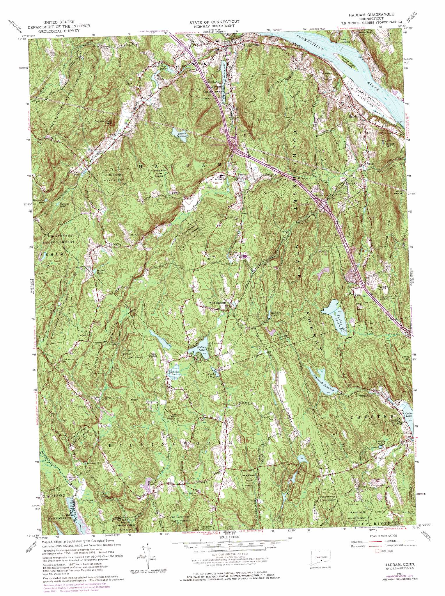
USGS Topo Quad 41072d5 - 1:24,000 scale
| Topo Map Name: | Haddam |
| USGS Topo Quad ID: | 41072d5 |
| Print Size: | ca. 21 1/4" wide x 27" high |
| Southeast Coordinates: | 41.375° N latitude / 72.5° W longitude |
| Map Center Coordinates: | 41.4375° N latitude / 72.5625° W longitude |
| U.S. State: | CT |
| Filename: | o41072d5.jpg |
| Download Map JPG Image: | Haddam topo map 1:24,000 scale |
| Map Type: | Topographic |
| Topo Series: | 7.5´ |
| Map Scale: | 1:24,000 |
| Source of Map Images: | United States Geological Survey (USGS) |
| Alternate Map Versions: |
Haddam CT 1952, updated 1959 Download PDF Buy paper map Haddam CT 1961, updated 1964 Download PDF Buy paper map Haddam CT 1961, updated 1972 Download PDF Buy paper map Haddam CT 1961, updated 1972 Download PDF Buy paper map Haddam CT 2012 Download PDF Buy paper map Haddam CT 2015 Download PDF Buy paper map |
1:24,000 Topo Quads surrounding Haddam
New Britain |
Hartford South |
Glastonbury |
Marlborough |
Columbia |
Meriden |
Middletown |
Middle Haddam |
Moodus |
Colchester |
Wallingford |
Durham |
Haddam |
Deep River |
Hamburg |
Branford |
Guilford |
Clinton |
Essex |
Old Lyme |
Orient |
> Back to 41072a1 at 1:100,000 scale
> Back to 41072a1 at 1:250,000 scale
> Back to U.S. Topo Maps home
Haddam topo map: Gazetteer
Haddam: Airports
Chester Airport elevation 117m 383′Haddam: Bars
Haddam Island Bar elevation 0m 0′Rock Landing Bar elevation 0m 0′
Haddam: Crossings
Interchange 7 elevation 46m 150′Interchange 8 elevation 75m 246′
Haddam: Dams
Hidden Lake Dam elevation 157m 515′Higganum Reservoir Dam elevation 33m 108′
Kroopa Pond Dam elevation 99m 324′
Murray Pond Number 2 Dam elevation 125m 410′
Pattaconk Reservoir Dam elevation 98m 321′
Scovill Reservoir Dam elevation 152m 498′
Upper Pond Dam elevation 63m 206′
Haddam: Forests
Cockaponset State Forest elevation 131m 429′Haddam: Islands
Haddam Island elevation 0m 0′Haddam: Lakes
Cedar Lake elevation 73m 239′Griswold Pond elevation 89m 291′
Hidden Lake elevation 157m 515′
Horseshoe Pond elevation 134m 439′
Kroopa Pond elevation 99m 324′
Lampes Pond elevation 78m 255′
Murray Ponds elevation 115m 377′
Old Mill Pond elevation 56m 183′
Palmers Pond elevation 103m 337′
Priess Pond elevation 78m 255′
Sawmill Pond elevation 163m 534′
Upper Pond elevation 63m 206′
Haddam: Mines
Gillette Quarry elevation 20m 65′Haddam: Parks
Haddam Center Historic District elevation 48m 157′Haddam Island State Park elevation 11m 36′
Haddam Meadows State Park elevation -2m -7′
Higganum Reservoir State Park elevation 32m 104′
Meeting House Green elevation 27m 88′
Haddam: Populated Places
Arnolds elevation 36m 118′Cedar Lake elevation 88m 288′
Haddam elevation 27m 88′
Higganum elevation 21m 68′
Little City elevation 181m 593′
Ponset elevation 101m 331′
Rock Landing elevation 5m 16′
West Haddam elevation 164m 538′
Haddam: Reservoirs
Bell Shop Pond elevation 63m 206′Black Shop Pond elevation 56m 183′
Fricks Pond elevation 152m 498′
Hackney Pond elevation 140m 459′
Higganum Reservoir elevation 33m 108′
Murray Pond Number 2 elevation 125m 410′
Pattaconk Reservoir elevation 98m 321′
Scovill Reservoir elevation 152m 498′
Turkey Hill Reservoir elevation 95m 311′
Haddam: Streams
Beaver Meadow Brook elevation 44m 144′Bible Rock Brook elevation 27m 88′
Candlewood Hill Brook elevation 59m 193′
Kriegers Brook elevation 0m 0′
Pole Bridge Brook elevation 41m 134′
Pond Meadow Brook elevation 61m 200′
Ponset Brook elevation 65m 213′
Saltpeter Brook elevation 91m 298′
Swain Johnson Brook elevation 0m 0′
Turkey Hill Brook elevation 36m 118′
Haddam: Summits
Big Hill elevation 33m 108′Bunker Hill elevation 135m 442′
Candlewood Hill elevation 110m 360′
Goose Hill elevation 201m 659′
Great Hill elevation 96m 314′
Long Hill elevation 154m 505′
Turkey Hill elevation 140m 459′
Walkley Hill elevation 54m 177′
Haddam: Swamps
Lower Swamp elevation 2m 6′Haddam digital topo map on disk
Buy this Haddam topo map showing relief, roads, GPS coordinates and other geographical features, as a high-resolution digital map file on DVD:
New York, Vermont, Connecticut & Western Massachusetts
Buy digital topo maps: New York, Vermont, Connecticut & Western Massachusetts