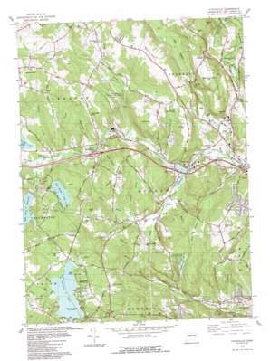
Fitchville Topo Map Connecticut
To zoom in, hover over the map of Fitchville
USGS Topo Quad 41072e2 - 1:24,000 scale
| Topo Map Name: | Fitchville |
| USGS Topo Quad ID: | 41072e2 |
| Print Size: | ca. 21 1/4" wide x 27" high |
| Southeast Coordinates: | 41.5° N latitude / 72.125° W longitude |
| Map Center Coordinates: | 41.5625° N latitude / 72.1875° W longitude |
| U.S. State: | CT |
| Filename: | o41072e2.jpg |
| Download Map JPG Image: | Fitchville topo map 1:24,000 scale |
| Map Type: | Topographic |
| Topo Series: | 7.5´ |
| Map Scale: | 1:24,000 |
| Source of Map Images: | United States Geological Survey (USGS) |
| Alternate Map Versions: |
Fitchville CT 1953, updated 1959 Download PDF Buy paper map Fitchville CT 1953, updated 1966 Download PDF Buy paper map Fitchville CT 1953, updated 1971 Download PDF Buy paper map Fitchville CT 1983, updated 1984 Download PDF Buy paper map Fitchville CT 2012 Download PDF Buy paper map Fitchville CT 2015 Download PDF Buy paper map |
1:24,000 Topo Quads surrounding Fitchville
> Back to 41072e1 at 1:100,000 scale
> Back to 41072a1 at 1:250,000 scale
> Back to U.S. Topo Maps home
Fitchville topo map: Gazetteer
Fitchville: Airports
Gager Field elevation 144m 472′Gardner Lake Airport elevation 144m 472′
Fitchville: Benches
Pequot Ledge elevation 123m 403′Fitchville: Crossings
Interchange 22 elevation 88m 288′Fitchville: Dams
Deep River Reservoir Dam elevation 106m 347′Fitchville Pond Dam elevation 48m 157′
Gardner Lake Dam elevation 116m 380′
Lake Marie Dam elevation 140m 459′
McGrath Dam elevation 77m 252′
Red Cedar Lake Dam elevation 135m 442′
Savin Lake Dam elevation 92m 301′
Tadma Pond Dam elevation 84m 275′
Yantic River Dam elevation 78m 255′
Fitchville: Islands
Minnie Island elevation 117m 383′Minnie Island elevation 117m 383′
Fitchville: Lakes
Gardner Lake elevation 116m 380′Kahn Ponds elevation 81m 265′
Mahoney Pond elevation 46m 150′
Pitchers Pond elevation 93m 305′
Savin Lake elevation 93m 305′
Tadma Pond elevation 84m 275′
Fitchville: Parks
Gardner Lake Park elevation 116m 380′Hopemead State Park elevation 136m 446′
Minnie Island State Park elevation 117m 383′
Fitchville: Populated Places
Avery Corner elevation 130m 426′Bargytown elevation 51m 167′
Fitchville elevation 50m 164′
Franklin elevation 129m 423′
Gilman elevation 85m 278′
Leffingwell (historical) elevation 36m 118′
Smith Corner elevation 58m 190′
Fitchville: Post Offices
Gilman Post Office elevation 66m 216′Fitchville: Reservoirs
Bishop Pond elevation 77m 252′Deep River Reservoir elevation 106m 347′
Fitchville Pond elevation 48m 157′
Gilman Pond elevation 78m 255′
Lake Marie elevation 140m 459′
Pitchers Pond elevation 93m 305′
Red Cedar Lake elevation 135m 442′
Savin Lake elevation 92m 301′
Fitchville: Streams
Austin Brook elevation 69m 226′Bentley Brook elevation 36m 118′
Deep River elevation 90m 295′
Driscoll Brook elevation 34m 111′
Elisha Brook elevation 37m 121′
Gardner Brook elevation 50m 164′
Gillette Brook elevation 91m 298′
Goldmine Brook elevation 25m 82′
Goshen Brook elevation 88m 288′
Hinckley Brook elevation 79m 259′
Hoxie Brook elevation 71m 232′
Johnnycake Brook elevation 44m 144′
Kahn Brook elevation 50m 164′
Mineral Spring Brook elevation 45m 147′
Pearson Brook elevation 67m 219′
Pease Brook elevation 58m 190′
Polly Brook elevation 76m 249′
Round Brook elevation 59m 193′
Sherman Brook elevation 93m 305′
Sucker Brook elevation 115m 377′
Susquetonscut Brook elevation 34m 111′
Waterman Brook elevation 75m 246′
Whittle Brook elevation 122m 400′
Fitchville: Summits
Ayers Mountain elevation 146m 479′Bargy Ledges elevation 151m 495′
Bashon Hill elevation 152m 498′
Bear Hill elevation 152m 498′
Blue Hill elevation 152m 498′
Bourn Hill elevation 136m 446′
Brush Hill elevation 113m 370′
Goshen Hill elevation 174m 570′
Mason Hill elevation 158m 518′
Meeting House Hill elevation 160m 524′
Misery Hill elevation 111m 364′
Pequot Ledge elevation 120m 393′
Pleasure Hill elevation 143m 469′
Scott Hill elevation 165m 541′
Standish Hill elevation 153m 501′
Wawecus Hill elevation 153m 501′
Fitchville: Swamps
Dark Swamp elevation 101m 331′Fitchville digital topo map on disk
Buy this Fitchville topo map showing relief, roads, GPS coordinates and other geographical features, as a high-resolution digital map file on DVD:
New York, Vermont, Connecticut & Western Massachusetts
Buy digital topo maps: New York, Vermont, Connecticut & Western Massachusetts


