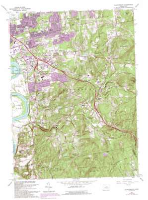
Glastonbury Topo Map Connecticut
To zoom in, hover over the map of Glastonbury
USGS Topo Quad 41072f5 - 1:24,000 scale
| Topo Map Name: | Glastonbury |
| USGS Topo Quad ID: | 41072f5 |
| Print Size: | ca. 21 1/4" wide x 27" high |
| Southeast Coordinates: | 41.625° N latitude / 72.5° W longitude |
| Map Center Coordinates: | 41.6875° N latitude / 72.5625° W longitude |
| U.S. State: | CT |
| Filename: | o41072f5.jpg |
| Download Map JPG Image: | Glastonbury topo map 1:24,000 scale |
| Map Type: | Topographic |
| Topo Series: | 7.5´ |
| Map Scale: | 1:24,000 |
| Source of Map Images: | United States Geological Survey (USGS) |
| Alternate Map Versions: |
Glastonbury CT 1928 Download PDF Buy paper map Glastonbury CT 1953, updated 1959 Download PDF Buy paper map Glastonbury CT 1964, updated 1965 Download PDF Buy paper map Glastonbury CT 1964, updated 1974 Download PDF Buy paper map Glastonbury CT 1964, updated 1984 Download PDF Buy paper map Glastonbury CT 1964, updated 1988 Download PDF Buy paper map Glastonbury CT 1964, updated 1992 Download PDF Buy paper map Glastonbury CT 1964, updated 1992 Download PDF Buy paper map Glastonbury CT 2012 Download PDF Buy paper map Glastonbury CT 2015 Download PDF Buy paper map |
1:24,000 Topo Quads surrounding Glastonbury
> Back to 41072e1 at 1:100,000 scale
> Back to 41072a1 at 1:250,000 scale
> Back to U.S. Topo Maps home
Glastonbury topo map: Gazetteer
Glastonbury: Airports
Corporate Center Heliport elevation 33m 108′Glastonbury: Cliffs
Crow Point elevation 0m 0′Glastonbury: Dams
Addison Pond Dam elevation 31m 101′Angus Park Pond Dam elevation 93m 305′
Cold Brook Reservoir Dam elevation 79m 259′
Williams Pond Dam elevation 21m 68′
Glastonbury: Flats
Glastonbury Meadows elevation 13m 42′Glastonbury: Forests
Meshomasic State Forest elevation 194m 636′Glastonbury: Lakes
Angus Park Pond elevation 93m 305′Brainard Pond elevation 74m 242′
Buckland Pond elevation 51m 167′
Caiglo Pond elevation 56m 183′
Great Pond elevation 21m 68′
Hills Pond elevation 43m 141′
Hodges Pond elevation 89m 291′
Miller Pond elevation 74m 242′
Potter Pond elevation 28m 91′
Rams Pond elevation 30m 98′
Red Gates Pond elevation 98m 321′
Rosers Pond elevation 37m 121′
Shoddy Mill Pond elevation 137m 449′
Treat Pond elevation 63m 206′
Williams Pond elevation 21m 68′
Williams Pond elevation 84m 275′
Glastonbury: Parks
Cotton Hollow Nature Preserve elevation 50m 164′Doctor Richard E Gorman Park elevation 24m 78′
Glastonbury Historic District elevation 15m 49′
Glastonbury Meadows State Wildlife Area elevation 11m 36′
Goodwin Playground elevation 22m 72′
Herbert T Clark Memorial Park elevation 15m 49′
J B Williams Memorial Park elevation 92m 301′
Manchester Recreation Center elevation 129m 423′
Reeves Lookout State Wildlife Area elevation 129m 423′
Rotary Field elevation 42m 137′
South Glastonbury Historic District elevation 25m 82′
Wangunk State Wildlife Area elevation 11m 36′
Welles Field elevation 17m 55′
Glastonbury: Populated Places
Addison elevation 35m 114′Buckingham elevation 137m 449′
Cotton Hollow elevation 42m 137′
East Glastonbury elevation 109m 357′
East Hartford Gardens elevation 16m 52′
Forbes Village elevation 29m 95′
Forest Village elevation 28m 91′
Glastonbury elevation 19m 62′
Glastonbury Center elevation 21m 68′
Hassunadchuauck (historical) elevation 99m 324′
Hopewell elevation 52m 170′
Naubuc (historical) elevation 16m 52′
South Glastonbury elevation 47m 154′
Taylor Town elevation 52m 170′
Welles Village elevation 33m 108′
Glastonbury: Post Offices
East Glastonbury Post Office elevation 92m 301′Glastonbury Post Office elevation 25m 82′
South Glastonbury Post Office elevation 25m 82′
Glastonbury: Reservoirs
Addison Pond elevation 33m 108′Cold Brook Reservoir elevation 79m 259′
Nipsic Pond elevation 121m 396′
Glastonbury: Springs
Red Spring elevation 123m 403′Glastonbury: Streams
Cold Brook elevation 82m 269′Dark Hollow Brook elevation 84m 275′
Grindle Brook elevation 20m 65′
Holland Brook elevation 14m 45′
Hubbard Brook elevation 9m 29′
Mott Hill Brook elevation 84m 275′
Roaring Brook elevation 6m 19′
Salmon Brook elevation 13m 42′
Slab Gut Brook elevation 68m 223′
Smith Brook elevation 6m 19′
Wildcat Brook elevation 48m 157′
Wintergreen Brook elevation 93m 305′
Glastonbury: Summits
Belltown Hill elevation 182m 597′Bush Hill elevation 97m 318′
Clark Hill elevation 206m 675′
Kongscut Mountain elevation 234m 767′
Meshomasic Mountain elevation 265m 869′
Minnechaug Mountain elevation 215m 705′
Red Hill elevation 27m 88′
Round Hill elevation 52m 170′
Town Woods Hill elevation 162m 531′
Glastonbury: Swamps
Glastonbury Meadows elevation 8m 26′Nipsic Bog elevation 121m 396′
Glastonbury digital topo map on disk
Buy this Glastonbury topo map showing relief, roads, GPS coordinates and other geographical features, as a high-resolution digital map file on DVD:
New York, Vermont, Connecticut & Western Massachusetts
Buy digital topo maps: New York, Vermont, Connecticut & Western Massachusetts


