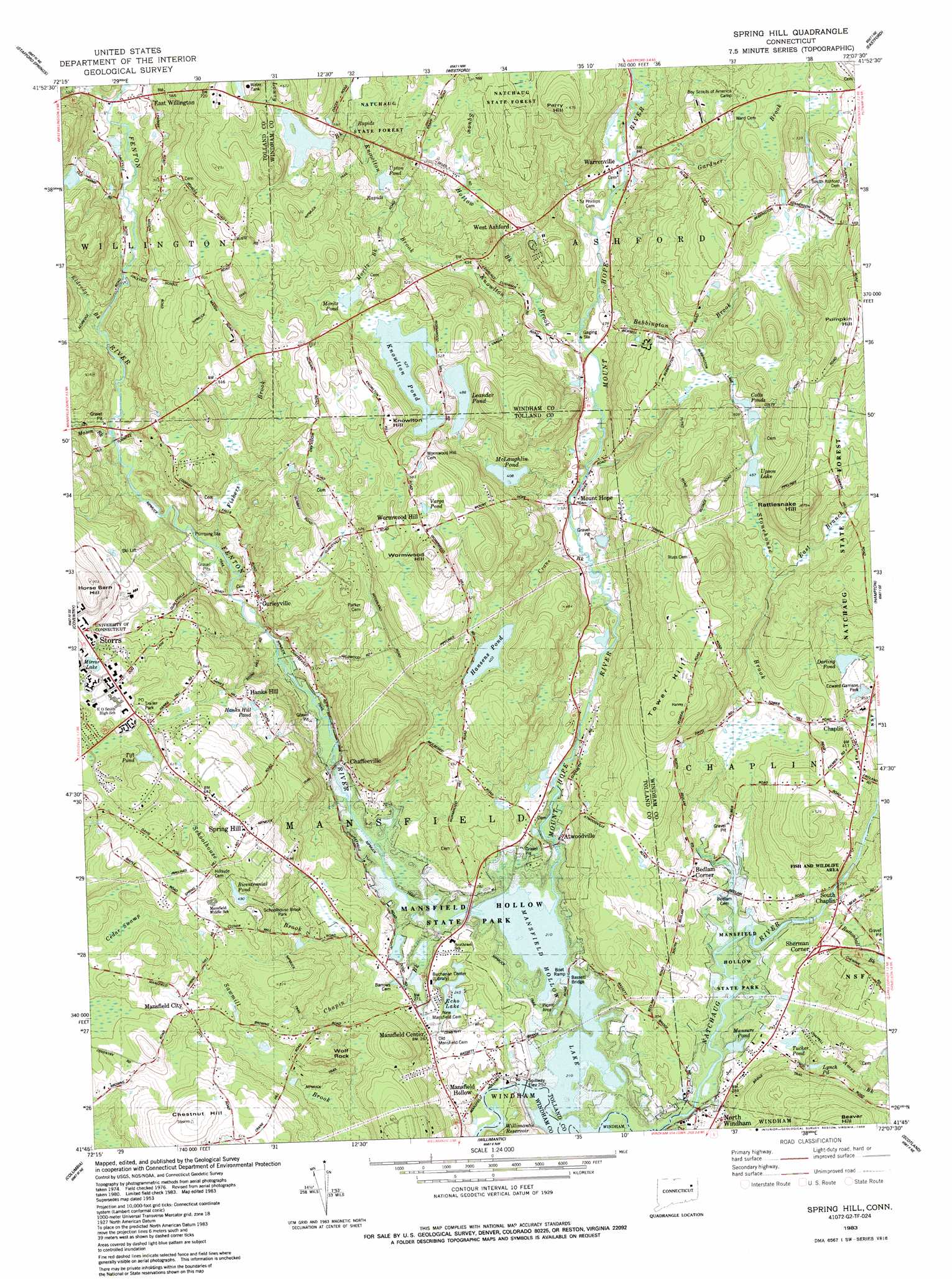
Spring Hill Topo Map Connecticut
To zoom in, hover over the map of Spring Hill
USGS Topo Quad 41072g2 - 1:24,000 scale
| Topo Map Name: | Spring Hill |
| USGS Topo Quad ID: | 41072g2 |
| Print Size: | ca. 21 1/4" wide x 27" high |
| Southeast Coordinates: | 41.75° N latitude / 72.125° W longitude |
| Map Center Coordinates: | 41.8125° N latitude / 72.1875° W longitude |
| U.S. State: | CT |
| Filename: | o41072g2.jpg |
| Download Map JPG Image: | Spring Hill topo map 1:24,000 scale |
| Map Type: | Topographic |
| Topo Series: | 7.5´ |
| Map Scale: | 1:24,000 |
| Source of Map Images: | United States Geological Survey (USGS) |
| Alternate Map Versions: |
Spring Hill CT 1953, updated 1959 Download PDF Buy paper map Spring Hill CT 1953, updated 1964 Download PDF Buy paper map Spring Hill CT 1953, updated 1971 Download PDF Buy paper map Spring Hill CT 1983, updated 1983 Download PDF Buy paper map Spring Hill CT 1983, updated 1988 Download PDF Buy paper map Spring Hill CT 1983, updated 1988 Download PDF Buy paper map Spring Hill CT 2012 Download PDF Buy paper map Spring Hill CT 2015 Download PDF Buy paper map |
1:24,000 Topo Quads surrounding Spring Hill
Hampden |
Monson |
Southbridge |
||
Ellington |
Stafford Springs |
Westford |
Eastford |
Putnam |
Rockville |
South Coventry |
Spring Hill |
Hampton |
Danielson |
Marlborough |
Columbia |
Willimantic |
Scotland |
Plainfield |
Moodus |
Colchester |
Fitchville |
Norwich |
Jewett City |
> Back to 41072e1 at 1:100,000 scale
> Back to 41072a1 at 1:250,000 scale
> Back to U.S. Topo Maps home
Spring Hill topo map: Gazetteer
Spring Hill: Bridges
Bassett Bridge elevation 78m 255′Spring Hill: Dams
Hansens Pond Dam elevation 123m 403′Happy Acres Dam elevation 175m 574′
Mansfield Hollow Dam elevation 78m 255′
Mansfield Recreation Pond Dam elevation 78m 255′
McLaughlin Pond Dam elevation 124m 406′
Wildlife Marsh Dam elevation 149m 488′
Spring Hill: Lakes
Chapins Pond elevation 78m 255′Colts Pond elevation 150m 492′
Darling Pond elevation 108m 354′
Echo Lake elevation 75m 246′
Hanks Hill Pond elevation 142m 465′
Hansens Pond elevation 123m 403′
Leander Pond elevation 149m 488′
Lynch Pond elevation 100m 328′
Mansfield Hollow Lake elevation 78m 255′
Mansure Pond elevation 78m 255′
Mirror Lake elevation 176m 577′
Tift Pond elevation 184m 603′
Tucker Pond elevation 90m 295′
Upson Lake elevation 139m 456′
Varga Pond elevation 193m 633′
Spring Hill: Parks
Chaplin Historic District elevation 120m 393′Jesias Byles Sanctuary elevation 157m 515′
Pompey Hollow Park elevation 130m 426′
Spring Hill: Populated Places
Atwoodville elevation 84m 275′Bedlam Corner elevation 93m 305′
Chaffeeville elevation 85m 278′
Chaplin elevation 121m 396′
East Willington elevation 144m 472′
Gurleyville elevation 104m 341′
Mansfield Center elevation 78m 255′
Mansfield City elevation 151m 495′
Mansfield Hollow elevation 70m 229′
Mount Hope elevation 98m 321′
Sherman Corner elevation 95m 311′
South Chaplin elevation 90m 295′
Spring Hill elevation 198m 649′
Storrs elevation 187m 613′
Warrenville elevation 120m 393′
West Ashford elevation 147m 482′
Wormwood Hill elevation 192m 629′
Spring Hill: Post Offices
Chaplin Post Office elevation 115m 377′Warrenville Post Office elevation 150m 492′
Spring Hill: Reservoirs
Happy Acres Pond elevation 175m 574′Knowlton Pond elevation 160m 524′
Mansfield Recreation Pond elevation 78m 255′
McLaughlin Pond elevation 124m 406′
Moritz Pond elevation 163m 534′
Rychlings Pond elevation 175m 574′
Upton Pond elevation 150m 492′
Wild Life Marsh Reservoir elevation 149m 488′
Spring Hill: Streams
Ames Brook elevation 78m 255′Bebbington Brook elevation 106m 347′
Buttonball Brook elevation 89m 291′
East Branch Stonehouse Brook elevation 138m 452′
Eldredge Brook elevation 122m 400′
Fenton River elevation 78m 255′
Fishers Brook elevation 90m 295′
Gardner Brook elevation 120m 393′
Goss Brook elevation 119m 390′
Knowlton Brook elevation 111m 364′
Lipps Brook elevation 157m 515′
Lowry Brook elevation 164m 538′
Mason Brook elevation 100m 328′
Moritz Brook elevation 135m 442′
Mount Hope River elevation 78m 255′
Schoolhouse Brook elevation 78m 255′
Squaw Hollow Brook elevation 105m 344′
Stonehouse Brook elevation 78m 255′
Spring Hill: Summits
Bucket Hill elevation 217m 711′Chestnut Hill elevation 184m 603′
Knowlton Hill elevation 200m 656′
Perry Hill elevation 205m 672′
Rattlesnake Hill elevation 218m 715′
Tower Hill elevation 185m 606′
Wolf Rock elevation 143m 469′
Wormwood Hill elevation 212m 695′
Spring Hill: Swamps
Cedar Swamp elevation 168m 551′Fox Swamp elevation 163m 534′
Turnip Meadow (historical) elevation 78m 255′
Spring Hill: Trails
Nipmuck Trail elevation 145m 475′Spring Hill: Valleys
Mansfield Hollow elevation 83m 272′Spring Hill digital topo map on disk
Buy this Spring Hill topo map showing relief, roads, GPS coordinates and other geographical features, as a high-resolution digital map file on DVD:
New York, Vermont, Connecticut & Western Massachusetts
Buy digital topo maps: New York, Vermont, Connecticut & Western Massachusetts