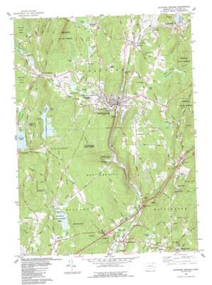
Stafford Springs Topo Map Connecticut
To zoom in, hover over the map of Stafford Springs
USGS Topo Quad 41072h3 - 1:24,000 scale
| Topo Map Name: | Stafford Springs |
| USGS Topo Quad ID: | 41072h3 |
| Print Size: | ca. 21 1/4" wide x 27" high |
| Southeast Coordinates: | 41.875° N latitude / 72.25° W longitude |
| Map Center Coordinates: | 41.9375° N latitude / 72.3125° W longitude |
| U.S. State: | CT |
| Filename: | o41072h3.jpg |
| Download Map JPG Image: | Stafford Springs topo map 1:24,000 scale |
| Map Type: | Topographic |
| Topo Series: | 7.5´ |
| Map Scale: | 1:24,000 |
| Source of Map Images: | United States Geological Survey (USGS) |
| Alternate Map Versions: |
Stafford Springs CT 1952, updated 1959 Download PDF Buy paper map Stafford Springs CT 1952, updated 1966 Download PDF Buy paper map Stafford Springs CT 1952, updated 1972 Download PDF Buy paper map Stafford Springs CT 1983, updated 1984 Download PDF Buy paper map Stafford Springs CT 2012 Download PDF Buy paper map Stafford Springs CT 2015 Download PDF Buy paper map |
1:24,000 Topo Quads surrounding Stafford Springs
> Back to 41072e1 at 1:100,000 scale
> Back to 41072a1 at 1:250,000 scale
> Back to U.S. Topo Maps home
Stafford Springs topo map: Gazetteer
Stafford Springs: Airports
Swift Airport elevation 161m 528′Stafford Springs: Beaches
Jimmy Ledges elevation 266m 872′Stafford Springs: Dams
Bradway Dam elevation 210m 688′Bradway Pond Dam elevation 169m 554′
Crystal Lake Dam elevation 195m 639′
Dennis Pond Dam elevation 166m 544′
Ellis Dam elevation 217m 711′
Ellithorpe Dam elevation 177m 580′
Glenville Pond Dam elevation 180m 590′
Halchek Pond Dam elevation 206m 675′
Hydeville Pond Dam elevation 191m 626′
Kent Hollow Dam elevation 175m 574′
Orcutts Pond Dam elevation 176m 577′
Parizek Pond Dam elevation 160m 524′
Rhode Island Ponds Dam elevation 159m 521′
Riverside Pond Dam elevation 176m 577′
Shenipsit Dam elevation 169m 554′
Springs Dam elevation 172m 564′
Staffordville Reservoir Dam elevation 213m 698′
Sun Valley Lake Dam elevation 166m 544′
Sweetheart Lake Dam elevation 136m 446′
Warren Pond Dam elevation 167m 547′
Whitney Dam elevation 173m 567′
Stafford Springs: Forests
Nye-Holman State Forest elevation 210m 688′Stafford Springs: Lakes
Arnold Ponds elevation 226m 741′Bradway Pond elevation 210m 688′
Foster Pond elevation 220m 721′
Rhode Island Millponds elevation 159m 521′
Sweetheart Lake elevation 136m 446′
Stafford Springs: Populated Places
Ellithorpe elevation 192m 629′Hydeville elevation 194m 636′
Lake View Terrace elevation 226m 741′
Orcutts elevation 175m 574′
Stafford elevation 177m 580′
Stafford Springs elevation 155m 508′
Staffordville elevation 218m 715′
West Stafford elevation 164m 538′
West Willington elevation 122m 400′
Willington Hill elevation 242m 793′
Stafford Springs: Reservoirs
Bradway Pond elevation 169m 554′Crystal Lake elevation 195m 639′
Dennis Pond elevation 166m 544′
Deversky Pond elevation 172m 564′
Ellis Brook Reservoir elevation 217m 711′
Ellithorpe Reservoir elevation 177m 580′
Ginholt Pond elevation 174m 570′
Glenville Pond elevation 180m 590′
Halchek Pond elevation 206m 675′
Hydeville Pond elevation 191m 626′
Orcutts Pond elevation 176m 577′
Parizek Pond elevation 160m 524′
Riverside Pond elevation 176m 577′
Ruby Lake elevation 186m 610′
Shenipsit Reservoir elevation 169m 554′
Springs Pond elevation 172m 564′
Staffordville Reservoir elevation 213m 698′
Sun Valley Lake elevation 166m 544′
Warren Pond elevation 167m 547′
Whitney Reservoir elevation 173m 567′
Stafford Springs: Streams
Aborn Brook elevation 194m 636′Alden Brook elevation 179m 587′
Alden Brook elevation 178m 583′
Baker Brook elevation 147m 482′
Bonemill Brook elevation 143m 469′
Brandy Brook elevation 190m 623′
Brooks Brook elevation 169m 554′
Charter Brook elevation 161m 528′
Crystal Lake Brook elevation 177m 580′
Diamond Ledge Brook elevation 167m 547′
Edson Brook elevation 161m 528′
Ellis Brook elevation 173m 567′
Frink Brook elevation 168m 551′
Furnace Brook elevation 150m 492′
Grapeville Brook elevation 109m 357′
Grover Brook elevation 170m 557′
Hatch Brook elevation 192m 629′
Keene Brook elevation 162m 531′
Labonte Brook elevation 118m 387′
McIntyres Brook elevation 196m 643′
Middle River elevation 150m 492′
Patten Brook elevation 171m 561′
Roaring Brook elevation 127m 416′
Ruby Brook elevation 170m 557′
School Brook elevation 118m 387′
Stoughton Brook elevation 215m 705′
Stafford Springs: Summits
Buff Cap Hill elevation 248m 813′Crow Hill elevation 292m 958′
Kendall Hill elevation 290m 951′
Murry Hill elevation 267m 875′
Neff Hill elevation 255m 836′
Parker Mountain elevation 275m 902′
Rockwell Hill elevation 274m 898′
Sugar Hill elevation 282m 925′
Tolland Hill elevation 246m 807′
Village Hill elevation 255m 836′
Whifford Hill elevation 291m 954′
Stafford Springs: Swamps
Cedar Swamp elevation 226m 741′Devils Hopyard Swamp elevation 210m 688′
Skungamaug Marsh elevation 169m 554′
Stafford Springs digital topo map on disk
Buy this Stafford Springs topo map showing relief, roads, GPS coordinates and other geographical features, as a high-resolution digital map file on DVD:
New York, Vermont, Connecticut & Western Massachusetts
Buy digital topo maps: New York, Vermont, Connecticut & Western Massachusetts


