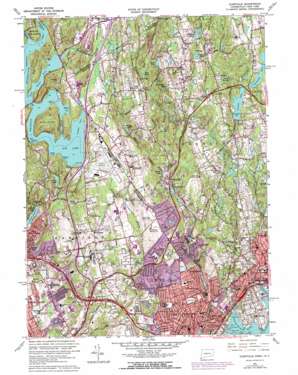
Glenville Topo Map Connecticut
To zoom in, hover over the map of Glenville
USGS Topo Quad 41073a6 - 1:24,000 scale
| Topo Map Name: | Glenville |
| USGS Topo Quad ID: | 41073a6 |
| Print Size: | ca. 21 1/4" wide x 27" high |
| Southeast Coordinates: | 41° N latitude / 73.625° W longitude |
| Map Center Coordinates: | 41.0625° N latitude / 73.6875° W longitude |
| U.S. States: | CT, NY |
| Filename: | o41073a6.jpg |
| Download Map JPG Image: | Glenville topo map 1:24,000 scale |
| Map Type: | Topographic |
| Topo Series: | 7.5´ |
| Map Scale: | 1:24,000 |
| Source of Map Images: | United States Geological Survey (USGS) |
| Alternate Map Versions: |
Glenville CT 1944, updated 1947 Download PDF Buy paper map Glenville CT 1951, updated 1959 Download PDF Buy paper map Glenville CT 1951, updated 1960 Download PDF Buy paper map Glenville CT 1960, updated 1962 Download PDF Buy paper map Glenville CT 1960, updated 1966 Download PDF Buy paper map Glenville CT 1960, updated 1973 Download PDF Buy paper map Glenville CT 1960, updated 1973 Download PDF Buy paper map Glenville CT 2012 Download PDF Buy paper map Glenville CT 2015 Download PDF Buy paper map |
1:24,000 Topo Quads surrounding Glenville
> Back to 41073a1 at 1:100,000 scale
> Back to 41072a1 at 1:250,000 scale
> Back to U.S. Topo Maps home
Glenville topo map: Gazetteer
Glenville: Airports
Old Orchard Road Heliport elevation 142m 465′Safe Flight Instrument Corporation Heliport elevation 123m 403′
Westchester Aviation Country Club (historical) elevation 112m 367′
Westchester County Airport elevation 122m 400′
Glenville: Bays
Bear Gutter Inlet elevation 108m 354′Byram Harbor elevation 0m 0′
Gutter Inlet elevation 108m 354′
Louden Cove elevation 108m 354′
Parks Cove elevation 108m 354′
Pleasantville Cove elevation 108m 354′
Webers Cove elevation 108m 354′
Wetzler Cove elevation 108m 354′
Woodmans Cove elevation 108m 354′
Glenville: Bridges
Pforzheimer Memorial Bridge elevation 126m 413′Rye Bridge elevation 108m 354′
Glenville: Capes
Bates Point elevation 110m 360′Big Peninsula elevation 159m 521′
Field Point elevation 3m 9′
Glenville: Channels
Dark Hollow elevation 108m 354′Glenville: Crossings
Interchange 2 elevation 17m 55′Interchange 22 elevation 50m 164′
Interchange 23 elevation 52m 170′
Interchange 24 elevation 82m 269′
Interchange 25 elevation 43m 141′
Interchange 26 elevation 61m 200′
Interchange 27 elevation 81m 265′
Interchange 28 elevation 76m 249′
Interchange 29 elevation 94m 308′
Interchange 3 elevation 6m 19′
Interchange 3 elevation 113m 370′
Interchange 31 elevation 102m 334′
Glenville: Dams
American Can Company Dam elevation 151m 495′American Felt Dam elevation 41m 134′
F W Perry Pond Dam elevation 111m 364′
Indian Spring Pond Dam elevation 32m 104′
Pemberwick Dam elevation 8m 26′
Putnam Reservoir Dam elevation 92m 301′
Rockwood Lake Dam elevation 101m 331′
Spahn Pond Dam elevation 64m 209′
Topping Pond Dam elevation 115m 377′
West Fork Pond Dam elevation 57m 187′
Wilshire Pond Dam elevation 126m 413′
Wooley Pond Dam elevation 89m 291′
Glenville: Flats
The Flat elevation 113m 370′Glenville: Islands
Causeway Island elevation 108m 354′Farwells Island elevation 3m 9′
Game Cock Island elevation 1m 3′
Goose Island elevation 53m 173′
Great Island elevation 165m 541′
Otter Rocks elevation 0m 0′
Rich Island elevation 0m 0′
Shore Island elevation 2m 6′
Wilson Head elevation 0m 0′
Glenville: Lakes
Closes Pond elevation 125m 410′Kensico Lake elevation 108m 354′
Lake Mead elevation 103m 337′
Rye Lake elevation 108m 354′
Silver Lake elevation 53m 173′
Toll Gate Pond elevation 43m 141′
Wooley Pond elevation 89m 291′
Glenville: Parks
Byram Park elevation 0m 0′Cannon Park elevation 9m 29′
Crawford Park elevation 62m 203′
Davenport Park elevation 35m 114′
Glen And Haseco Park elevation 20m 65′
Greenwich Avenue Historic District elevation 26m 85′
Greenwich Common elevation 30m 98′
Greenwich Municipal Center Historic District elevation 24m 78′
Havemeyer Fields elevation 30m 98′
John Lyon Park elevation 40m 131′
Liberty Square elevation 5m 16′
Memorial Park elevation 40m 131′
Pemberwick Park elevation 41m 134′
Roger Sherman Baldwin Park elevation 1m 3′
Silver Lake Park elevation 74m 242′
Summerfield Park elevation 7m 22′
Western Greenwich Civic Center Park elevation 37m 121′
Wild Flower Sanctuary elevation 111m 364′
Glenville: Populated Places
Belle Haven elevation 21m 68′Byram elevation 16m 52′
East Port Chester (historical) elevation 20m 65′
East White Plains elevation 85m 278′
Glenville elevation 52m 170′
Greenwich elevation 28m 91′
North Greenwich elevation 156m 511′
Pemberwick elevation 10m 32′
Pine Hill elevation 122m 400′
Port Chester elevation 13m 42′
Purchase elevation 107m 351′
Riversville elevation 48m 157′
Rock Ridge elevation 33m 108′
Rye Brook elevation 76m 249′
Glenville: Post Offices
Greenwich Post Office elevation 17m 55′Glenville: Reservoirs
Byram River Reservoir elevation 8m 26′Carringtons Pond elevation 111m 364′
F W Perry Pond elevation 111m 364′
Forest Lake elevation 73m 239′
Indian Spring Pond elevation 32m 104′
Mill Pond elevation 41m 134′
North Lake elevation 151m 495′
Putnam Lake elevation 92m 301′
Rockwood Lake elevation 101m 331′
Spahn Pond elevation 64m 209′
Spring Lake elevation 46m 150′
Topping Pond elevation 115m 377′
West Fork Pond elevation 57m 187′
Wilcox Pond elevation 58m 190′
Wilshire Pond elevation 126m 413′
Glenville: Ridges
Quaker Ridge elevation 130m 426′Glenville: Streams
Bear Gutter Creek elevation 108m 354′Converse Pond Brook elevation 51m 167′
East Branch Byram River elevation 45m 147′
East Branch Converse Pond Brook elevation 45m 147′
Horseneck Brook elevation 8m 26′
Wampus River elevation 109m 357′
Wilshire Pond Brook elevation 94m 308′
Wilshire Pond Brook elevation 94m 308′
Glenville: Summits
Cooney Hill elevation 170m 557′High Point elevation 136m 446′
Round Hill elevation 172m 564′
Glenville: Swamps
Wolf Swamp elevation 117m 383′Glenville digital topo map on disk
Buy this Glenville topo map showing relief, roads, GPS coordinates and other geographical features, as a high-resolution digital map file on DVD:
New York, Vermont, Connecticut & Western Massachusetts
Buy digital topo maps: New York, Vermont, Connecticut & Western Massachusetts


