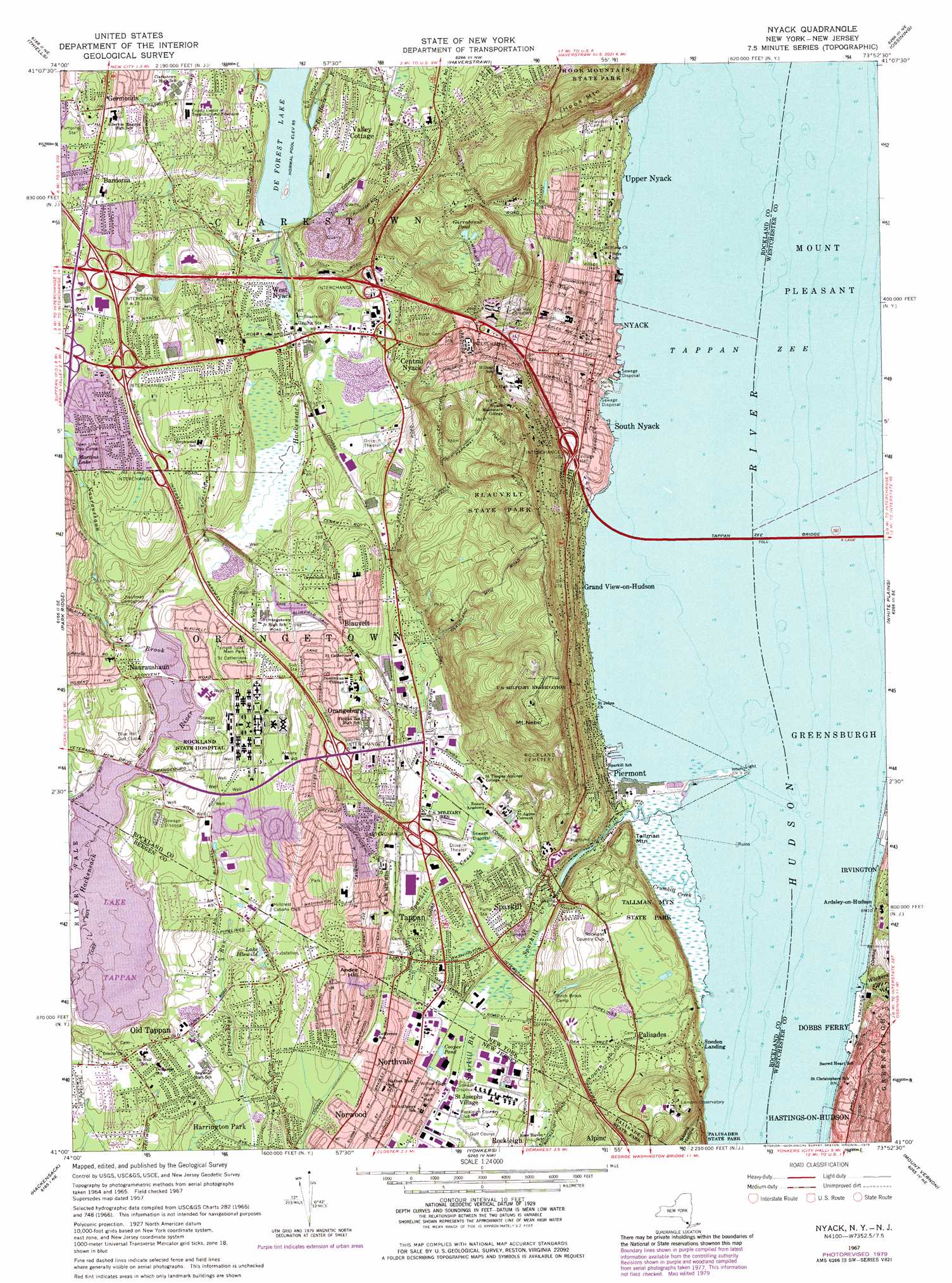
Nyack Topo Map New York
To zoom in, hover over the map of Nyack
USGS Topo Quad 41073a8 - 1:24,000 scale
| Topo Map Name: | Nyack |
| USGS Topo Quad ID: | 41073a8 |
| Print Size: | ca. 21 1/4" wide x 27" high |
| Southeast Coordinates: | 41° N latitude / 73.875° W longitude |
| Map Center Coordinates: | 41.0625° N latitude / 73.9375° W longitude |
| U.S. States: | NY, NJ |
| Filename: | o41073a8.jpg |
| Download Map JPG Image: | Nyack topo map 1:24,000 scale |
| Map Type: | Topographic |
| Topo Series: | 7.5´ |
| Map Scale: | 1:24,000 |
| Source of Map Images: | United States Geological Survey (USGS) |
| Alternate Map Versions: |
Nyack NY 1937 Download PDF Buy paper map Nyack NY 1940, updated 1952 Download PDF Buy paper map Nyack NY 1957, updated 1959 Download PDF Buy paper map Nyack NY 1957, updated 1964 Download PDF Buy paper map Nyack NY 1967, updated 1969 Download PDF Buy paper map Nyack NY 1967, updated 1976 Download PDF Buy paper map Nyack NY 1967, updated 1979 Download PDF Buy paper map Nyack NY 2011 Download PDF Buy paper map Nyack NY 2013 Download PDF Buy paper map Nyack NY 2016 Download PDF Buy paper map |
1:24,000 Topo Quads surrounding Nyack
Monroe |
Popolopen Lake |
Peekskill |
Mohegan Lake |
Croton Falls |
Sloatsburg |
Thiells |
Haverstraw |
Ossining |
Mount Kisco |
Ramsey |
Park Ridge |
Nyack |
White Plains |
Glenville |
Paterson |
Hackensack |
Yonkers |
Mount Vernon |
Mamaroneck |
Orange |
Weehawken |
Central Park |
Flushing |
Sea Cliff |
> Back to 41073a1 at 1:100,000 scale
> Back to 41072a1 at 1:250,000 scale
> Back to U.S. Topo Maps home
Nyack topo map: Gazetteer
Nyack: Airports
IBM Customer Executive Education Center Heliport elevation 56m 183′Nyack: Bridges
Tappan Zee Bridge elevation 0m 0′Nyack: Crossings
Interchange 10 elevation 26m 85′Interchange 11 elevation 64m 209′
Interchange 12 elevation 32m 104′
Interchange 5 elevation 23m 75′
Interchange 6 elevation 65m 213′
Interchange 7 elevation 67m 219′
Interchange 8 elevation 81m 265′
Interchange 9 elevation 83m 272′
Nyack: Dams
Lake Tappan Dam elevation 17m 55′Nyack: Lakes
Cooper Pond elevation 9m 29′Garrabrant Pond elevation 139m 456′
Lake Idlewild elevation 27m 88′
Martins Lake elevation 61m 200′
Tappan Zee elevation 0m 0′
Nyack: Mines
West Nyack Trap Rock Quarry elevation 41m 134′Nyack: Parks
Aldine Park elevation 54m 177′Blauvelt State Park elevation 93m 305′
Buttermilk Falls Park elevation 60m 196′
Clausland Mountain County Park elevation 138m 452′
Memorial Park elevation 16m 52′
Memorial Park elevation 3m 9′
Mountainview Nature Park elevation 60m 196′
Palisades State Park elevation 63m 206′
Piermont Marsh Component Hudson River National Estuarine Research Reserve elevation 0m 0′
Schaefer Park elevation 42m 137′
Schuyler Town Park elevation 125m 410′
Tackamack Park elevation 78m 255′
Tallman Mountain State Park elevation 53m 173′
Veteran's Memorial Park elevation 19m 62′
Willow Edge Park elevation 9m 29′
Nyack: Populated Places
Bardonia elevation 90m 295′Blauvelt elevation 61m 200′
Central Nyack elevation 19m 62′
Germonds elevation 90m 295′
Grand View-on-Hudson elevation 0m 0′
Nauraushaun elevation 34m 111′
Northvale elevation 12m 39′
Nyack elevation 22m 72′
Old Tappan elevation 24m 78′
Orangeburg elevation 34m 111′
Palisades elevation 60m 196′
Piermont elevation 29m 95′
Rockleigh elevation 20m 65′
Saint Josephs Village elevation 12m 39′
South Nyack elevation 22m 72′
Sparkill elevation 16m 52′
Tappan elevation 14m 45′
Upper Nyack elevation 58m 190′
Valley Cottage elevation 54m 177′
West Norwood elevation 26m 85′
West Nyack elevation 24m 78′
Nyack: Post Offices
Northvale Post Office elevation 18m 59′Nyack Post Office elevation 21m 68′
Nyack: Reservoirs
Lydscker Pond (historical) elevation 63m 206′Nyack: Streams
Crumkill Creek elevation 0m 0′East Branch Hackensack River elevation 27m 88′
Nauraushaun Brook elevation 16m 52′
Sparkill Brook elevation 8m 26′
Sparkill Creek elevation 0m 0′
Sparkill Creek elevation 0m 0′
Wickers Creek elevation 1m 3′
Nyack: Summits
Andre Hill elevation 50m 164′Hook Mountain elevation 214m 702′
Mount Nebo elevation 208m 682′
Tallman Mountain elevation 52m 170′
Nyack: Valleys
Skunk Hollow elevation 0m 0′Nyack: Woods
Maiwalds Grove elevation 18m 59′Nyack digital topo map on disk
Buy this Nyack topo map showing relief, roads, GPS coordinates and other geographical features, as a high-resolution digital map file on DVD:
New York, Vermont, Connecticut & Western Massachusetts
Buy digital topo maps: New York, Vermont, Connecticut & Western Massachusetts