Ansonia Topo Map Connecticut
To zoom in, hover over the map of Ansonia
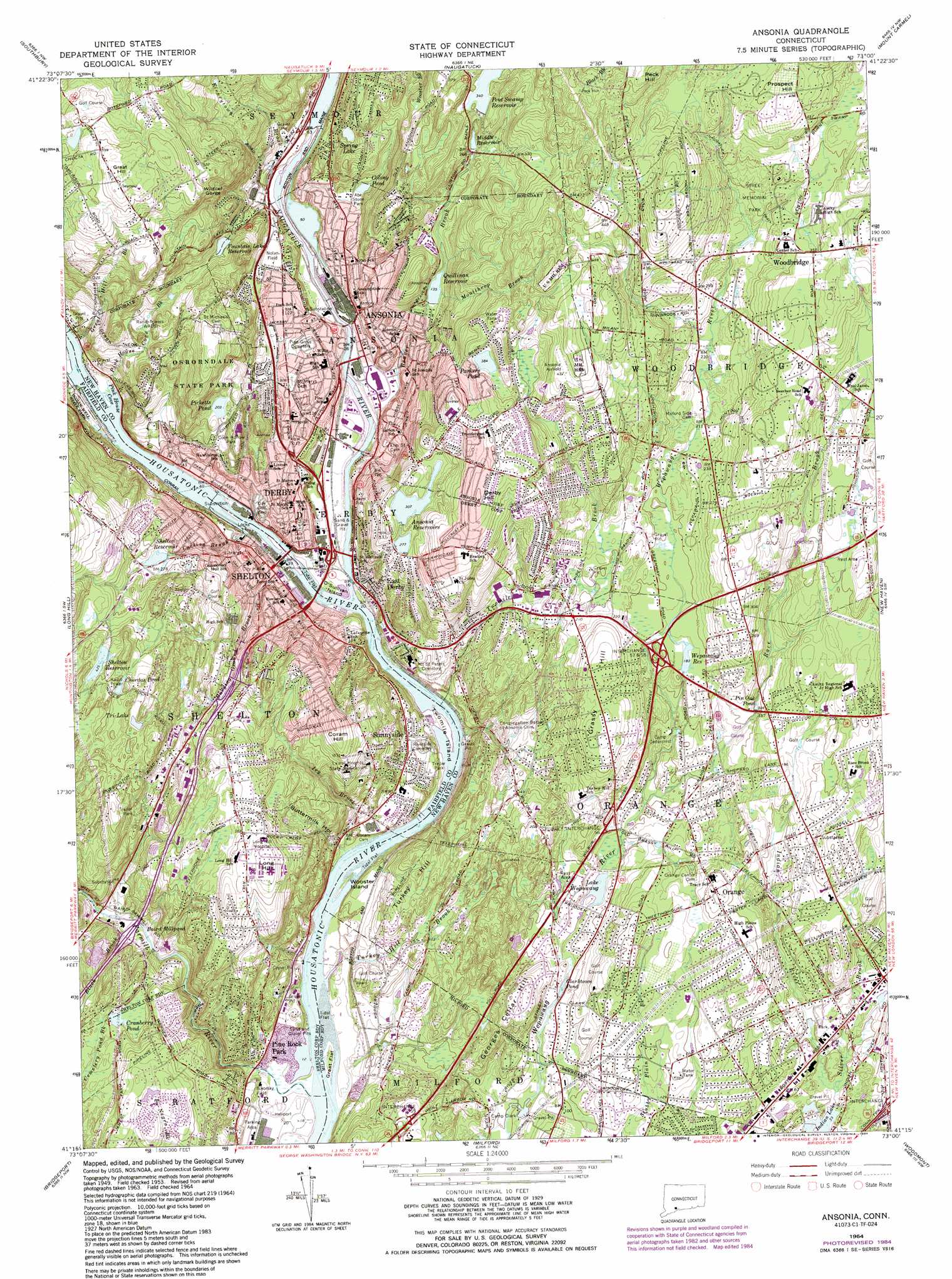
USGS Topo Quad 41073c1 - 1:24,000 scale
| Topo Map Name: | Ansonia |
| USGS Topo Quad ID: | 41073c1 |
| Print Size: | ca. 21 1/4" wide x 27" high |
| Southeast Coordinates: | 41.25° N latitude / 73° W longitude |
| Map Center Coordinates: | 41.3125° N latitude / 73.0625° W longitude |
| U.S. State: | CT |
| Filename: | o41073c1.jpg |
| Download Map JPG Image: | Ansonia topo map 1:24,000 scale |
| Map Type: | Topographic |
| Topo Series: | 7.5´ |
| Map Scale: | 1:24,000 |
| Source of Map Images: | United States Geological Survey (USGS) |
| Alternate Map Versions: |
Ansonia CT 1953, updated 1959 Download PDF Buy paper map Ansonia CT 1953, updated 1960 Download PDF Buy paper map Ansonia CT 1964, updated 1967 Download PDF Buy paper map Ansonia CT 1964, updated 1974 Download PDF Buy paper map Ansonia CT 1964, updated 1984 Download PDF Buy paper map Ansonia CT 1964, updated 1984 Download PDF Buy paper map Ansonia CT 2012 Download PDF Buy paper map Ansonia CT 2015 Download PDF Buy paper map |
1:24,000 Topo Quads surrounding Ansonia
Roxbury |
Woodbury |
Waterbury |
Southington |
Meriden |
Newtown |
Southbury |
Naugatuck |
Mount Carmel |
Wallingford |
Botsford |
Long Hill |
Ansonia |
New Haven |
Branford |
Westport |
Bridgeport |
Milford |
Woodmont |
|
Sherwood Point |
> Back to 41073a1 at 1:100,000 scale
> Back to 41072a1 at 1:250,000 scale
> Back to U.S. Topo Maps home
Ansonia topo map: Gazetteer
Ansonia: Airports
Ansonia Airfield elevation 140m 459′Ansonia: Bars
Camp Meeting Bar elevation 0m 0′Drews Bar elevation 0m 0′
Hidelum Rock Bar elevation 6m 19′
Moulthrops Bar elevation 23m 75′
Twomile Island Bar elevation 72m 236′
Ansonia: Bays
Pink House Cove elevation 6m 19′Ansonia: Capes
Hawkins Point elevation 3m 9′O' Sullivan Island elevation 0m 0′
Ansonia: Crossings
Interchange 55 elevation 66m 216′Interchange 56 elevation 35m 114′
Interchange 57 elevation 64m 209′
Ansonia: Dams
Anaconda American Brass Company Dam elevation 21m 68′Fountain Lake Dam elevation 77m 252′
Kinneytown Dam elevation 16m 52′
Lake Housatonic Dam elevation 6m 19′
Lake Housatonic Dike elevation 100m 328′
Lower Ansonia Reservoir Dam elevation 93m 305′
Middle Reservoir Dam elevation 85m 278′
Peat Swamp Reservoir Dam elevation 115m 377′
Picketts Pond Dam elevation 70m 229′
Quillinan Reservoir Dam elevation 49m 160′
Shelton Reservoir Number 2 Dam elevation 79m 259′
Shelton Reservoir Number 3 Dam elevation 131m 429′
Sow and Pigs Jetty elevation 17m 55′
Upper Ansonia Reservoir Dam elevation 85m 278′
Wepawaug Reservoir Dam elevation 56m 183′
Ansonia: Flats
Great Flat elevation 2m 6′Ansonia: Islands
Hog Island elevation 0m 0′Twomile Island elevation 8m 26′
Wooster Island elevation 12m 39′
Ansonia: Lakes
Baird Millpond elevation 31m 101′Chordas Pond elevation 144m 472′
Clarktown Pond elevation 27m 88′
Colony Pond elevation 38m 124′
Cranberry Pond elevation 54m 177′
Indian Lake elevation 8m 26′
Lake Wepawaug elevation 23m 75′
Parkers Pond elevation 117m 383′
Pin Oak Pond elevation 48m 157′
Spring Lake elevation 59m 193′
Tri-Lake elevation 121m 396′
Ansonia: Parks
Abe Stone Park elevation 52m 170′Abe Stone Park elevation 88m 288′
Charles E Wheeler Wildlife Area elevation 0m 0′
Coon Hollow Park elevation 73m 239′
Eisenhower Park elevation 26m 85′
Far Mill Park elevation 49m 160′
Nelligan Park elevation 130m 426′
Nolan Field elevation 39m 127′
Orange Center Historic District elevation 65m 213′
Osborndale State Park elevation 135m 442′
Pine Rock Park elevation 45m 147′
Red Root Park elevation 50m 164′
Riverview Park elevation 26m 85′
Sunnyside Field elevation 26m 85′
Upper Main Street Historic District elevation 14m 45′
Warsaw Park elevation 117m 383′
Ansonia: Populated Places
Ansonia elevation 26m 85′Derby elevation 31m 101′
East Derby elevation 28m 91′
Kinneytown elevation 35m 114′
Orange elevation 68m 223′
Oronoque Hills North elevation 86m 282′
Pine Rock Park elevation 15m 49′
Shelton elevation 19m 62′
Sunnyside elevation 36m 118′
Sunnyside Trailer Park elevation 25m 82′
Woodbridge elevation 116m 380′
Ansonia: Post Offices
Derby Post Office elevation 34m 111′Shelton Post Office elevation 21m 68′
Ansonia: Reservoirs
Ansonia Reservoir elevation 97m 318′Bristols Ice Pond (historical) elevation 20m 65′
Coe Pond elevation 17m 55′
Cone Pond elevation 21m 68′
Crosbys Pond elevation 26m 85′
Fountain Lake Reservoir elevation 77m 252′
Lake Housatonic elevation 6m 19′
Lower Ansonia Reservoir elevation 93m 305′
Middle Reservoir elevation 85m 278′
Naugatuck River Reservoir elevation 16m 52′
Peat Swamp Reservoir elevation 115m 377′
Picketts Pond elevation 70m 229′
Quillinan Reservoir elevation 49m 160′
Shelton Reservoir elevation 79m 259′
Shelton Reservoir elevation 130m 426′
Shelton Reservoir Number 3 elevation 131m 429′
Skelton Reservoir elevation 91m 298′
Upper Ansonia Reservoir elevation 85m 278′
Wepawaug Reservoir elevation 56m 183′
Ansonia: Streams
Beaver Brook elevation 9m 29′Black Brook elevation 34m 111′
Burying Ground Brook elevation 18m 59′
Butternut Hollow Brook elevation 1m 3′
Curtiss Brook elevation 20m 65′
Farmill River elevation 1m 3′
Great Hill Brook elevation 6m 19′
Indian Hole Brook elevation 27m 88′
Ivy Brook elevation 0m 0′
Kinneytown Brook elevation 18m 59′
Moulthrap Brook elevation 58m 190′
Naugatuck River elevation 0m 0′
Pink House Cove Brook elevation 7m 22′
Race Brook elevation 29m 95′
Turkey Hill Brook elevation 1m 3′
Turkey Hill Brook elevation 0m 0′
Turkey Hill Brook elevation 0m 0′
Twomile Brook elevation 1m 3′
Ansonia: Summits
Baldwin Hill elevation 123m 403′Coram Hill elevation 130m 426′
Derby Hill elevation 143m 469′
Georges Cellar Hill elevation 64m 209′
Grassy Hill elevation 93m 305′
Great Hill elevation 202m 662′
Long Hill elevation 124m 406′
Peck Hill elevation 171m 561′
Prospect Hill elevation 153m 501′
Turkey Hill elevation 62m 203′
Windy Hill elevation 41m 134′
Ansonia: Swamps
Grape Swamp elevation 117m 383′Ansonia: Valleys
Buttermilk Hollow elevation 16m 52′Wildcat Gorge elevation 48m 157′
Ansonia digital topo map on disk
Buy this Ansonia topo map showing relief, roads, GPS coordinates and other geographical features, as a high-resolution digital map file on DVD:
New York, Vermont, Connecticut & Western Massachusetts
Buy digital topo maps: New York, Vermont, Connecticut & Western Massachusetts