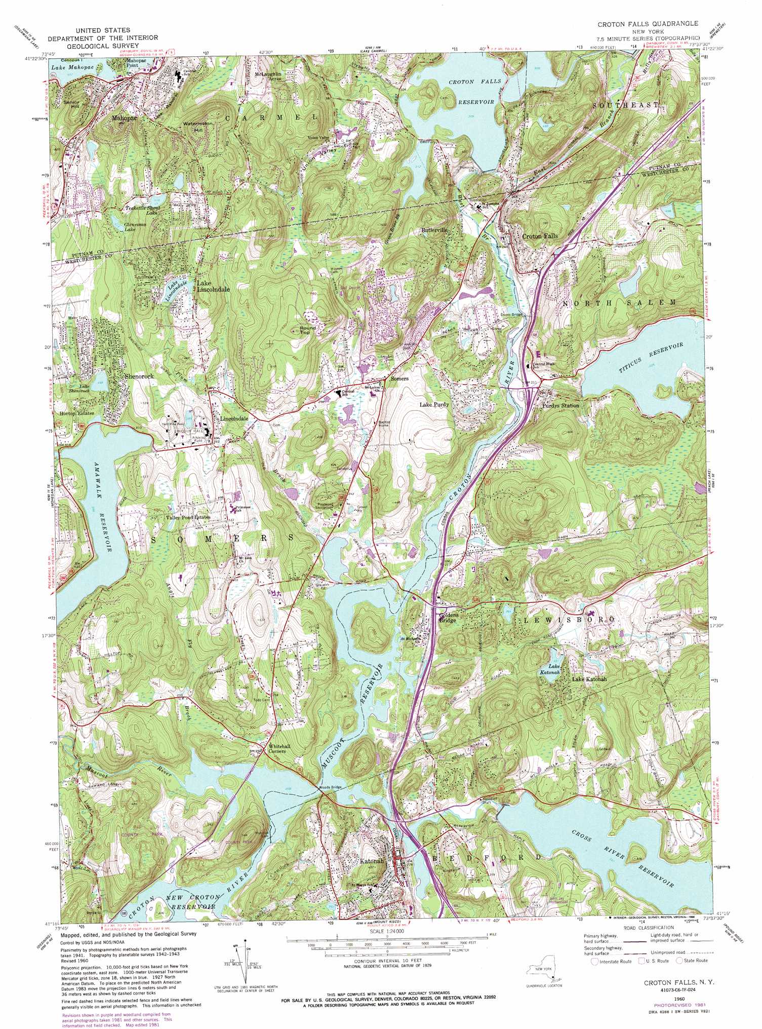
Croton Falls Topo Map New York
To zoom in, hover over the map of Croton Falls
USGS Topo Quad 41073c6 - 1:24,000 scale
| Topo Map Name: | Croton Falls |
| USGS Topo Quad ID: | 41073c6 |
| Print Size: | ca. 21 1/4" wide x 27" high |
| Southeast Coordinates: | 41.25° N latitude / 73.625° W longitude |
| Map Center Coordinates: | 41.3125° N latitude / 73.6875° W longitude |
| U.S. State: | NY |
| Filename: | o41073c6.jpg |
| Download Map JPG Image: | Croton Falls topo map 1:24,000 scale |
| Map Type: | Topographic |
| Topo Series: | 7.5´ |
| Map Scale: | 1:24,000 |
| Source of Map Images: | United States Geological Survey (USGS) |
| Alternate Map Versions: |
Croton Falls NY 1944, updated 1960 Download PDF Buy paper map Croton Falls NY 1960, updated 1963 Download PDF Buy paper map Croton Falls NY 1960, updated 1967 Download PDF Buy paper map Croton Falls NY 1960, updated 1982 Download PDF Buy paper map Croton Falls NY 1960, updated 1986 Download PDF Buy paper map Croton Falls NY 2010 Download PDF Buy paper map Croton Falls NY 2013 Download PDF Buy paper map Croton Falls NY 2016 Download PDF Buy paper map |
1:24,000 Topo Quads surrounding Croton Falls
Wappingers Falls |
Hopewell Junction |
Poughquag |
Pawling |
New Milford |
West Point |
Oscawana Lake |
Lake Carmel |
Brewster |
Danbury |
Peekskill |
Mohegan Lake |
Croton Falls |
Peach Lake |
Bethel |
Haverstraw |
Ossining |
Mount Kisco |
Pound Ridge |
Norwalk North |
Nyack |
White Plains |
Glenville |
Stamford |
Norwalk South |
> Back to 41073a1 at 1:100,000 scale
> Back to 41072a1 at 1:250,000 scale
> Back to U.S. Topo Maps home
Croton Falls topo map: Gazetteer
Croton Falls: Airports
IBM Sommers Heliport elevation 148m 485′Croton Falls: Bridges
Deans Bridge elevation 64m 209′Woods Bridge elevation 61m 200′
Croton Falls: Canals
Delaware Aqueduct elevation 116m 380′Croton Falls: Crossings
Casey's Crossing elevation 69m 226′Interchange 5 elevation 80m 262′
Interchange 6 elevation 75m 246′
Interchange 6A elevation 64m 209′
Interchange 7 elevation 64m 209′
Interchange 8 elevation 98m 321′
Croton Falls: Dams
Muscoot Dam elevation 61m 200′Croton Falls: Islands
Duck Island elevation 101m 331′Croton Falls: Lakes
Bloomer Pond elevation 178m 583′Lake Lincolndale elevation 143m 469′
Croton Falls: Parks
Bailey Park elevation 84m 275′Fox Valley Town Park elevation 111m 364′
Grierson Preserve elevation 117m 383′
Joe Bohrdrum Field Park elevation 164m 538′
John Jay Homestead State Historic Site elevation 142m 465′
Katonah Memorial Park elevation 117m 383′
Lasdon Park elevation 125m 410′
Mildred B Lasdon Sanctuary elevation 107m 351′
Mount Holly Sanctuary elevation 183m 600′
Muscoot Farm Park elevation 67m 219′
Reis Park elevation 137m 449′
Van Tassel Memorial Park elevation 164m 538′
Yarrow Preserve elevation 174m 570′
Croton Falls: Populated Places
Butlerville elevation 89m 291′Croton Falls elevation 82m 269′
Goldens Bridge elevation 66m 216′
Heritage Hills elevation 179m 587′
Horton Estates elevation 133m 436′
Katonah elevation 72m 236′
Katonah Ridge elevation 81m 265′
Lake Katonah elevation 129m 423′
Lake Lincolndale elevation 149m 488′
Lake Purdy elevation 101m 331′
Lincolndale elevation 103m 337′
Mahopac elevation 203m 666′
McLaughlin Acres elevation 163m 534′
Purdys elevation 77m 252′
Shenorock elevation 155m 508′
Somers elevation 85m 278′
Valley Pond Estates elevation 147m 482′
Whitehall Corners elevation 75m 246′
Croton Falls: Post Offices
Katonah Post Office elevation 69m 226′Purdys Post Office elevation 90m 295′
Shenorock Post Office elevation 162m 531′
Croton Falls: Reservoirs
Cross River Reservoir elevation 81m 265′Croton Falls Reservoir elevation 93m 305′
Glencoma Lake elevation 156m 511′
Lake Hawthorne elevation 103m 337′
Lake Katonah elevation 100m 328′
Lake Shenorock elevation 142m 465′
Muscoot Reservoir elevation 61m 200′
Teakettle Spout Lake elevation 187m 613′
Titicus Reservoir elevation 86m 282′
Croton Falls: Ridges
Flintlock Ridge elevation 187m 613′Lake Mahopac Ridge elevation 239m 784′
Croton Falls: Streams
Angle Fly Brook elevation 61m 200′Cross River elevation 61m 200′
East Branch Croton River elevation 62m 203′
Green Briar Brook elevation 96m 314′
Holly Stream elevation 84m 275′
Middle Branch Croton River elevation 94m 308′
Muscoot River elevation 61m 200′
Plum Brook elevation 62m 203′
Stone Hill River elevation 62m 203′
West Branch Croton River elevation 62m 203′
Croton Falls: Summits
Harvey Birch Hill elevation 215m 705′Mount Zion elevation 175m 574′
Round Top elevation 223m 731′
Senior Hill elevation 292m 958′
Watermelon Hill elevation 290m 951′
Croton Falls: Valleys
Union Valley elevation 120m 393′Croton Falls digital topo map on disk
Buy this Croton Falls topo map showing relief, roads, GPS coordinates and other geographical features, as a high-resolution digital map file on DVD:
New York, Vermont, Connecticut & Western Massachusetts
Buy digital topo maps: New York, Vermont, Connecticut & Western Massachusetts