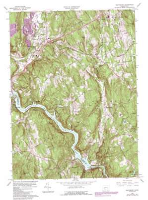
Southbury Topo Map Connecticut
To zoom in, hover over the map of Southbury
USGS Topo Quad 41073d2 - 1:24,000 scale
| Topo Map Name: | Southbury |
| USGS Topo Quad ID: | 41073d2 |
| Print Size: | ca. 21 1/4" wide x 27" high |
| Southeast Coordinates: | 41.375° N latitude / 73.125° W longitude |
| Map Center Coordinates: | 41.4375° N latitude / 73.1875° W longitude |
| U.S. State: | CT |
| Filename: | o41073d2.jpg |
| Download Map JPG Image: | Southbury topo map 1:24,000 scale |
| Map Type: | Topographic |
| Topo Series: | 7.5´ |
| Map Scale: | 1:24,000 |
| Source of Map Images: | United States Geological Survey (USGS) |
| Alternate Map Versions: |
Southbury CT 1953, updated 1959 Download PDF Buy paper map Southbury CT 1953, updated 1962 Download PDF Buy paper map Southbury CT 1964, updated 1966 Download PDF Buy paper map Southbury CT 1964, updated 1974 Download PDF Buy paper map Southbury CT 1964, updated 1984 Download PDF Buy paper map Southbury CT 1964, updated 1985 Download PDF Buy paper map Southbury CT 1964, updated 1988 Download PDF Buy paper map Southbury CT 2012 Download PDF Buy paper map Southbury CT 2015 Download PDF Buy paper map |
1:24,000 Topo Quads surrounding Southbury
> Back to 41073a1 at 1:100,000 scale
> Back to 41072a1 at 1:250,000 scale
> Back to U.S. Topo Maps home
Southbury topo map: Gazetteer
Southbury: Airports
Waterbury-Oxford Airport elevation 220m 721′Southbury: Bays
Jackson Cove elevation 33m 108′Southbury: Dams
Great Hill Reservoir Dam elevation 92m 301′Stevenson Dam elevation 11m 36′
Warner Pond Dam elevation 140m 459′
Southbury: Forests
Paugussett State Forest elevation 120m 393′Southbury: Lakes
Nichols Pond elevation 197m 646′Papermill Pond elevation 151m 495′
Southbury: Parks
Edward Park elevation 55m 180′Jackson Cove Park elevation 50m 164′
Kettletown State Park elevation 48m 157′
Lake Zoar Wildlife Area elevation 42m 137′
Platt Park elevation 116m 380′
Southbury Historic District Number 1 elevation 78m 255′
Southford Falls State Park elevation 161m 528′
Tyringham Cobble Park elevation 178m 583′
Union Square elevation 59m 193′
Southbury: Populated Places
Bowers Hill elevation 117m 383′Cedar Land elevation 64m 209′
Cedarhurst elevation 78m 255′
Heritage Village elevation 108m 354′
Kettletown elevation 182m 597′
Lakeside elevation 55m 180′
Quaker Farms elevation 113m 370′
Riverside elevation 76m 249′
Riverside elevation 56m 183′
Southbury elevation 76m 249′
Southford elevation 155m 508′
Stevenson elevation 111m 364′
Southbury: Post Offices
Southbury Post Office elevation 61m 200′Southbury: Reservoirs
Great Hill Reservoir elevation 92m 301′Lake Zoar elevation 20m 65′
Warner Pond elevation 140m 459′
Southbury: Streams
Boys Halfway River elevation 34m 111′Bullet Hill Brook elevation 58m 190′
Eightmile Brook elevation 25m 82′
Fivemile Brook elevation 18m 59′
Jeremy Brook elevation 94m 308′
Kettletown Brook elevation 36m 118′
Lee Brook elevation 41m 134′
Pole Bridge Brook elevation 38m 124′
Round Hill Brook elevation 12m 39′
Sevenmile Brook elevation 93m 305′
Sixmile Brook elevation 95m 311′
South Branch Bullet Hill Brook elevation 68m 223′
Walnut Hill Brook elevation 145m 475′
Southbury: Summits
Bowers Hill elevation 128m 419′Bucks Hill elevation 217m 711′
Bullet Hill elevation 146m 479′
Durkee Hill elevation 128m 419′
Fivemile Hill elevation 223m 731′
Georges Hill elevation 189m 620′
Good Hill elevation 188m 616′
High Rock Hill elevation 187m 613′
Hulls Hill elevation 148m 485′
Ichabod Hill elevation 174m 570′
Mount Pisgah elevation 205m 672′
Osborn Hill elevation 206m 675′
Preston Hill elevation 205m 672′
Rattlesnake Hill elevation 140m 459′
Rockhouse Hill elevation 192m 629′
Walnut Hill elevation 242m 793′
Southbury digital topo map on disk
Buy this Southbury topo map showing relief, roads, GPS coordinates and other geographical features, as a high-resolution digital map file on DVD:
New York, Vermont, Connecticut & Western Massachusetts
Buy digital topo maps: New York, Vermont, Connecticut & Western Massachusetts


