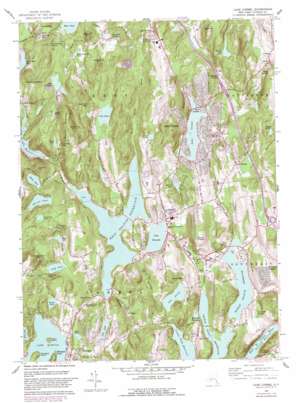
Lake Carmel Topo Map New York
To zoom in, hover over the map of Lake Carmel
USGS Topo Quad 41073d6 - 1:24,000 scale
| Topo Map Name: | Lake Carmel |
| USGS Topo Quad ID: | 41073d6 |
| Print Size: | ca. 21 1/4" wide x 27" high |
| Southeast Coordinates: | 41.375° N latitude / 73.625° W longitude |
| Map Center Coordinates: | 41.4375° N latitude / 73.6875° W longitude |
| U.S. State: | NY |
| Filename: | o41073d6.jpg |
| Download Map JPG Image: | Lake Carmel topo map 1:24,000 scale |
| Map Type: | Topographic |
| Topo Series: | 7.5´ |
| Map Scale: | 1:24,000 |
| Source of Map Images: | United States Geological Survey (USGS) |
| Alternate Map Versions: |
Lake Carmel NY 1943, updated 1958 Download PDF Buy paper map Lake Carmel NY 1960, updated 1962 Download PDF Buy paper map Lake Carmel NY 1960, updated 1966 Download PDF Buy paper map Lake Carmel NY 1960, updated 1982 Download PDF Buy paper map Lake Carmel NY 1960, updated 1982 Download PDF Buy paper map Lake Carmel NY 2010 Download PDF Buy paper map Lake Carmel NY 2013 Download PDF Buy paper map Lake Carmel NY 2016 Download PDF Buy paper map |
1:24,000 Topo Quads surrounding Lake Carmel
> Back to 41073a1 at 1:100,000 scale
> Back to 41072a1 at 1:250,000 scale
> Back to U.S. Topo Maps home
Lake Carmel topo map: Gazetteer
Lake Carmel: Capes
Mahopac Point elevation 214m 702′Lake Carmel: Crossings
Interchange 18 elevation 228m 748′Interchange 19 elevation 177m 580′
Whitney's Corners elevation 163m 534′
Lake Carmel: Islands
Canopus Island elevation 223m 731′Petre Island elevation 216m 708′
Lake Carmel: Lakes
Barrett Pond elevation 237m 777′Bird Pond elevation 245m 803′
China Pond elevation 234m 767′
Clear Pool elevation 252m 826′
Dean Pond elevation 222m 728′
Indian Brook Pond elevation 213m 698′
Lake Carmel elevation 188m 616′
Lake Casse elevation 184m 603′
Lake Gilead elevation 151m 495′
Lake Mahopac elevation 200m 656′
Lake Nimham elevation 221m 725′
Little Buck Mountain Pond elevation 252m 826′
Lockwood Pond elevation 257m 843′
Long Pond elevation 198m 649′
Mud Pond elevation 185m 606′
Palmer Lake elevation 179m 587′
Pine Pond elevation 183m 600′
Seven Hills Lake elevation 194m 636′
Wixon Pond elevation 219m 718′
Wonder Lake elevation 280m 918′
Lake Carmel: Populated Places
Allen Corners elevation 183m 600′Berkshire Terrace elevation 264m 866′
Brewster Heights elevation 189m 620′
Carmel elevation 171m 561′
Carmel Hills elevation 168m 551′
Carmel Park Estates elevation 269m 882′
Crafts elevation 132m 433′
Deans Corner elevation 95m 311′
Drewville Heights elevation 143m 469′
Farmers Mills elevation 238m 780′
Field Corners elevation 202m 662′
Kent Corners elevation 204m 669′
Kent Hills elevation 259m 849′
Knolls Trailer Court elevation 200m 656′
Lake Carmel elevation 244m 800′
Tilly Foster elevation 124m 406′
Lake Carmel: Reservoirs
Boyd Corners Reservoir elevation 175m 574′Dixon Lake elevation 214m 702′
Lake Gleneida elevation 154m 505′
Middle Branch Reservoir elevation 113m 370′
West Branch Reservoir elevation 153m 501′
Lake Carmel: Streams
Bailey Brook elevation 172m 564′Horse Pound Brook elevation 154m 505′
Michael Brook elevation 94m 308′
Stump Pond Stream elevation 188m 616′
Lake Carmel: Summits
Bare Hill elevation 314m 1030′Big Buck Mountain elevation 339m 1112′
Big Hill elevation 374m 1227′
Hitchcock Hill elevation 292m 958′
Horse Pound Hill elevation 290m 951′
Kidney Hill elevation 312m 1023′
Little Buck Mountain elevation 289m 948′
Mount Nimham elevation 388m 1272′
Mount Pisgah elevation 230m 754′
Stockholm Hill elevation 310m 1017′
Turkey Hill elevation 275m 902′
Lake Carmel digital topo map on disk
Buy this Lake Carmel topo map showing relief, roads, GPS coordinates and other geographical features, as a high-resolution digital map file on DVD:
New York, Vermont, Connecticut & Western Massachusetts
Buy digital topo maps: New York, Vermont, Connecticut & Western Massachusetts


