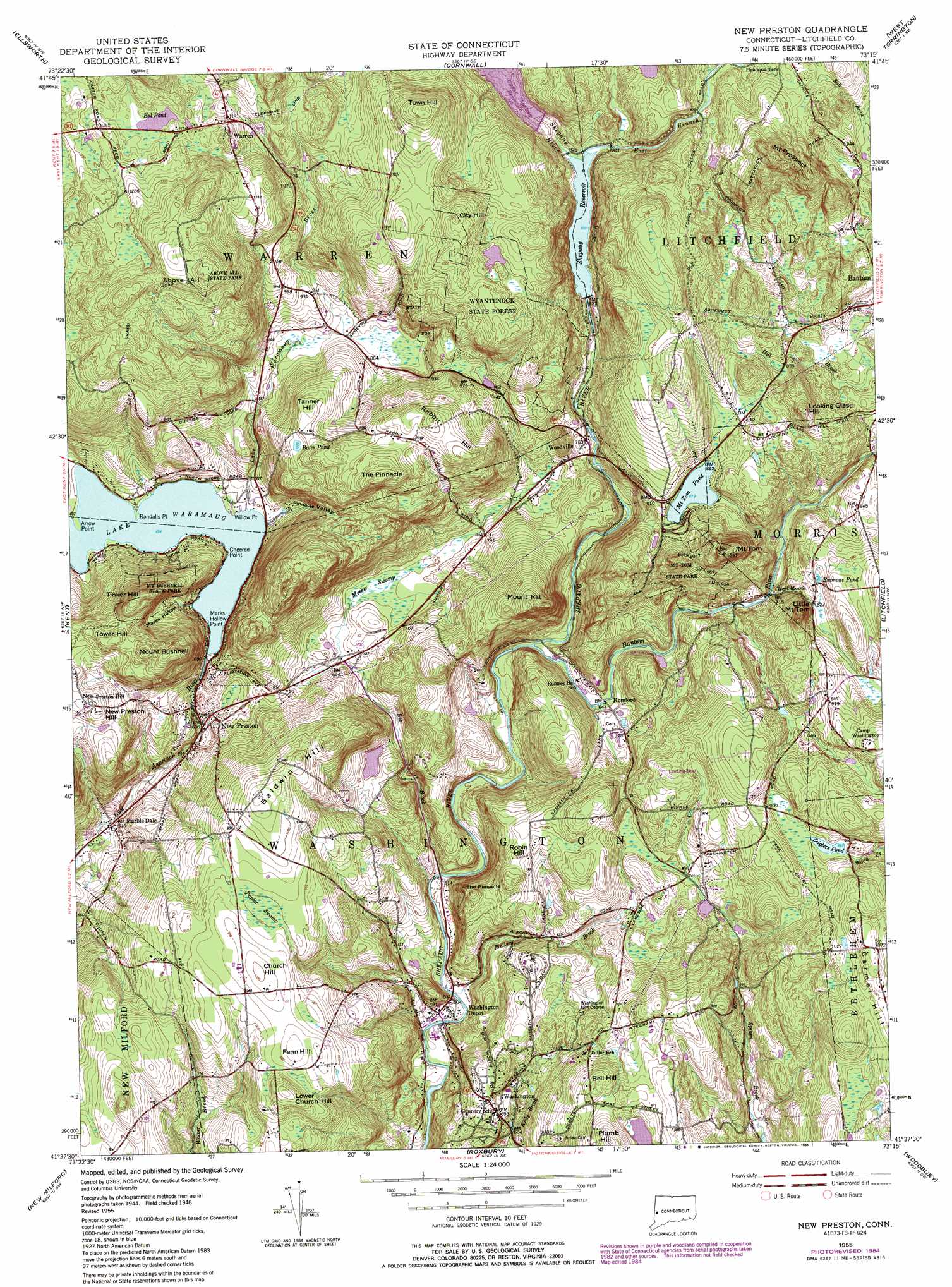
New Preston Topo Map Connecticut
To zoom in, hover over the map of New Preston
USGS Topo Quad 41073f3 - 1:24,000 scale
| Topo Map Name: | New Preston |
| USGS Topo Quad ID: | 41073f3 |
| Print Size: | ca. 21 1/4" wide x 27" high |
| Southeast Coordinates: | 41.625° N latitude / 73.25° W longitude |
| Map Center Coordinates: | 41.6875° N latitude / 73.3125° W longitude |
| U.S. State: | CT |
| Filename: | o41073f3.jpg |
| Download Map JPG Image: | New Preston topo map 1:24,000 scale |
| Map Type: | Topographic |
| Topo Series: | 7.5´ |
| Map Scale: | 1:24,000 |
| Source of Map Images: | United States Geological Survey (USGS) |
| Alternate Map Versions: |
New Preston CT 1955, updated 1958 Download PDF Buy paper map New Preston CT 1955, updated 1965 Download PDF Buy paper map New Preston CT 1955, updated 1972 Download PDF Buy paper map New Preston CT 1955, updated 1977 Download PDF Buy paper map New Preston CT 1955, updated 1984 Download PDF Buy paper map New Preston CT 1955, updated 1988 Download PDF Buy paper map New Preston CT 2012 Download PDF Buy paper map New Preston CT 2015 Download PDF Buy paper map |
1:24,000 Topo Quads surrounding New Preston
Millerton |
Sharon |
South Canaan |
Norfolk |
Winsted |
Amenia |
Ellsworth |
Cornwall |
West Torrington |
Torrington |
Dover Plains |
Kent |
New Preston |
Litchfield |
Thomaston |
Pawling |
New Milford |
Roxbury |
Woodbury |
Waterbury |
Brewster |
Danbury |
Newtown |
Southbury |
Naugatuck |
> Back to 41073e1 at 1:100,000 scale
> Back to 41072a1 at 1:250,000 scale
> Back to U.S. Topo Maps home
New Preston topo map: Gazetteer
New Preston: Airports
Clouds Hill Stolport elevation 285m 935′New Preston: Capes
Arrow Point elevation 211m 692′Cheeree Point elevation 213m 698′
Marks Hollow Point elevation 212m 695′
Randalls Point elevation 211m 692′
Willow Point elevation 212m 695′
New Preston: Dams
Goose Pond Dam elevation 311m 1020′Quist Pond Dam elevation 202m 662′
Shepaug Reservoir Dam elevation 249m 816′
Upper Shepaug Reservoir Dam elevation 280m 918′
New Preston: Lakes
Bates Pond elevation 327m 1072′Eel Pond elevation 370m 1213′
Emmons Pond elevation 260m 853′
Lake Waramaug elevation 211m 692′
Mount Tom Pond elevation 268m 879′
Zeiglers Pond elevation 270m 885′
New Preston: Parks
Above All State Park elevation 448m 1469′Bryan Plaza elevation 145m 475′
Mount Bushnell State Park elevation 358m 1174′
Mount Tom State Park elevation 299m 980′
New Preston Hill Historic District elevation 304m 997′
New Preston: Pillars
The Pinnacle elevation 254m 833′The Pinnacle elevation 391m 1282′
New Preston: Populated Places
Emmons City (historical) elevation 263m 862′Marble Dale elevation 158m 518′
New Preston elevation 203m 666′
Romford elevation 201m 659′
Warren elevation 380m 1246′
Washington elevation 224m 734′
West Morris elevation 245m 803′
Woodville elevation 237m 777′
New Preston: Reservoirs
Goose Pond elevation 311m 1020′Quist Pond elevation 202m 662′
Shepaug Reservoir elevation 249m 816′
Upper Shepaug Reservoir elevation 280m 918′
New Preston: Streams
Bantam River elevation 185m 606′Bee Brook elevation 156m 511′
East Branch Shepaug River elevation 250m 820′
Lake Waramaug Brook elevation 211m 692′
Mallory Brook elevation 146m 479′
West Branch Shepaug River elevation 250m 820′
New Preston: Summits
Above All elevation 450m 1476′Baldwin Hill elevation 315m 1033′
Bell Hill elevation 299m 980′
Church Hill elevation 305m 1000′
City Hill elevation 413m 1354′
Fenn Hill elevation 303m 994′
Little Mount Tom elevation 331m 1085′
Looking Glass Hill elevation 331m 1085′
Lower Church Hill elevation 324m 1062′
Mount Bushnell elevation 363m 1190′
Mount Prospect elevation 400m 1312′
Mount Rat elevation 352m 1154′
Mount Tom elevation 393m 1289′
New Preston Hill elevation 305m 1000′
Plumb Hill elevation 322m 1056′
Rabbit Hill elevation 385m 1263′
Robin Hill elevation 260m 853′
Tanner Hill elevation 342m 1122′
Tinker Hill elevation 364m 1194′
Tower Hill elevation 340m 1115′
Town Hill elevation 429m 1407′
New Preston: Swamps
Meeker Swamp elevation 208m 682′Poplar Swamp elevation 289m 948′
New Preston: Valleys
Marks Hollow elevation 237m 777′Pinnacle Valley elevation 215m 705′
New Preston digital topo map on disk
Buy this New Preston topo map showing relief, roads, GPS coordinates and other geographical features, as a high-resolution digital map file on DVD:
New York, Vermont, Connecticut & Western Massachusetts
Buy digital topo maps: New York, Vermont, Connecticut & Western Massachusetts