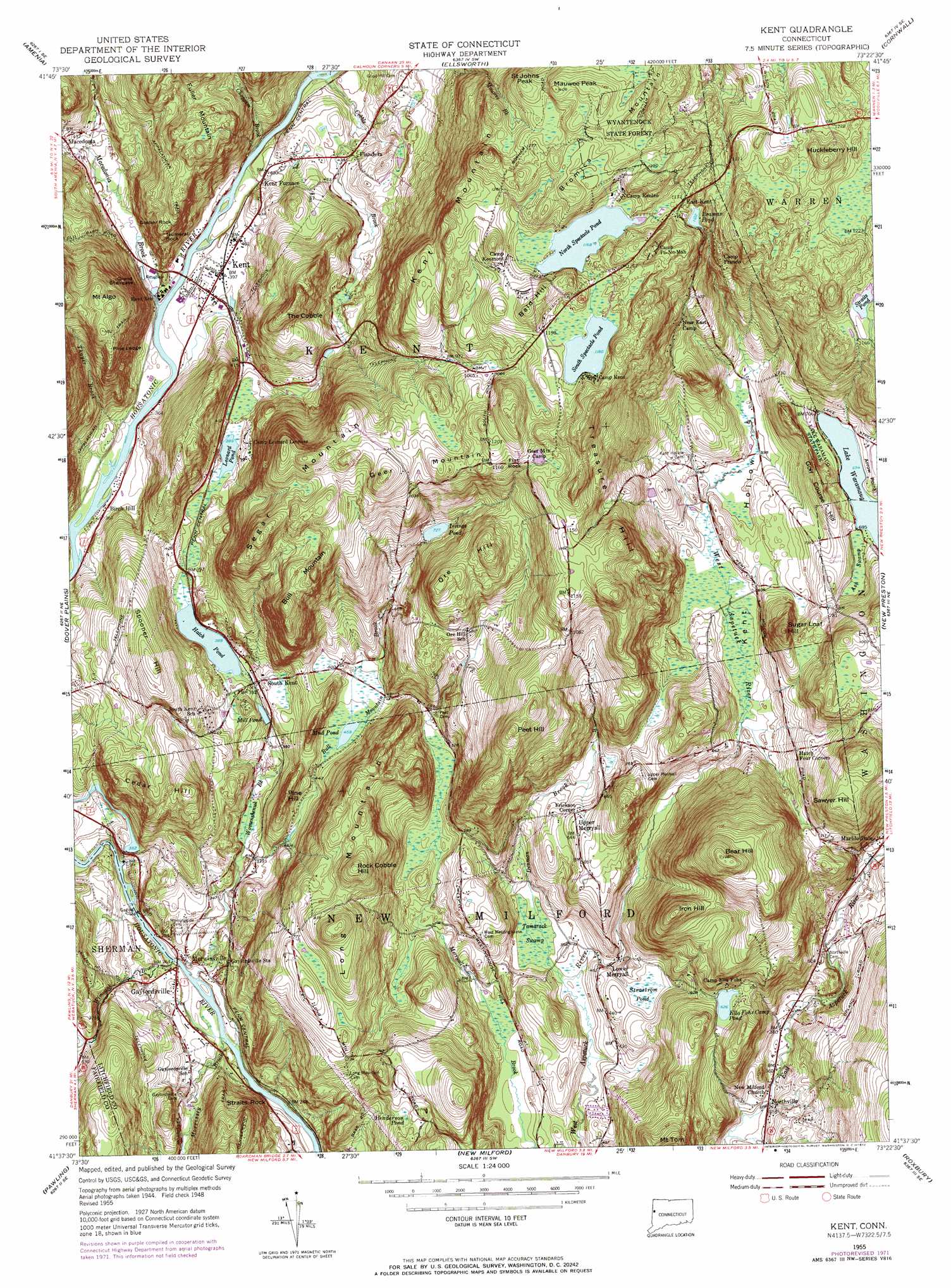
Kent Topo Map Connecticut
To zoom in, hover over the map of Kent
USGS Topo Quad 41073f4 - 1:24,000 scale
| Topo Map Name: | Kent |
| USGS Topo Quad ID: | 41073f4 |
| Print Size: | ca. 21 1/4" wide x 27" high |
| Southeast Coordinates: | 41.625° N latitude / 73.375° W longitude |
| Map Center Coordinates: | 41.6875° N latitude / 73.4375° W longitude |
| U.S. State: | CT |
| Filename: | o41073f4.jpg |
| Download Map JPG Image: | Kent topo map 1:24,000 scale |
| Map Type: | Topographic |
| Topo Series: | 7.5´ |
| Map Scale: | 1:24,000 |
| Source of Map Images: | United States Geological Survey (USGS) |
| Alternate Map Versions: |
Kent CT 1955, updated 1958 Download PDF Buy paper map Kent CT 1955, updated 1965 Download PDF Buy paper map Kent CT 1955, updated 1972 Download PDF Buy paper map Kent CT 2012 Download PDF Buy paper map Kent CT 2015 Download PDF Buy paper map |
1:24,000 Topo Quads surrounding Kent
Pine Plains |
Millerton |
Sharon |
South Canaan |
Norfolk |
Millbrook |
Amenia |
Ellsworth |
Cornwall |
West Torrington |
Verbank |
Dover Plains |
Kent |
New Preston |
Litchfield |
Poughquag |
Pawling |
New Milford |
Roxbury |
Woodbury |
Lake Carmel |
Brewster |
Danbury |
Newtown |
Southbury |
> Back to 41073e1 at 1:100,000 scale
> Back to 41072a1 at 1:250,000 scale
> Back to U.S. Topo Maps home
Kent topo map: Gazetteer
Kent: Bridges
Fuller Bridge elevation 109m 357′Gaylord Bridge elevation 70m 229′
Kent: Cliffs
Grand Staircase elevation 138m 452′Pine Ledge elevation 220m 721′
Kent: Dams
Cedar Hill Pond Dam elevation 107m 351′Ella Fohs Camp Pond Dam elevation 191m 626′
Irvings Pond Dam elevation 221m 725′
Straits Pond Dam elevation 358m 1174′
Kent: Lakes
Beaman Pond elevation 344m 1128′Hatch Pond elevation 118m 387′
Henderson Pond elevation 206m 675′
Leonard Pond elevation 118m 387′
Mud Pond elevation 139m 456′
North Spectacle Pond elevation 355m 1164′
South Spectacle Pond elevation 359m 1177′
Straits Pond elevation 358m 1174′
Strastrom Pond elevation 145m 475′
Kent: Parks
Emery Park elevation 145m 475′Emmanuel Williamson Park elevation 90m 295′
Flanders Historic District elevation 136m 446′
Iron Mountain Reservation elevation 279m 915′
Kent Green elevation 120m 393′
Lake Waramaug State Park elevation 214m 702′
Kent: Populated Places
East Kent elevation 360m 1181′Erickson Corner elevation 188m 616′
Flanders elevation 131m 429′
Gaylordsville elevation 79m 259′
Hickory Haven elevation 111m 364′
Kent elevation 119m 390′
Kent Furnace elevation 120m 393′
Lower Merryall elevation 133m 436′
Macedonia elevation 135m 442′
Merwinsville elevation 81m 265′
Northville elevation 107m 351′
South Kent elevation 125m 410′
Upper Merryall elevation 194m 636′
Kent: Post Offices
Gaylordsville Post Office elevation 84m 275′Kent Post Office elevation 121m 396′
Kent: Reservoirs
Cedar Hill Pond elevation 107m 351′Ella Fohs Camp Pond elevation 191m 626′
Irvings Pond elevation 218m 715′
Mill Pond elevation 113m 370′
Kent: Streams
Bog Hollow Brook elevation 119m 390′Bog Hollow Brook elevation 119m 390′
Bull Mountain Brook elevation 70m 229′
Choggam Brook elevation 109m 357′
Cobble Brook elevation 110m 360′
Denman Brook elevation 119m 390′
Macedonia Brook elevation 110m 360′
Morrissey Brook elevation 70m 229′
Squash Hollow Brook elevation 74m 242′
Thayer Brook elevation 110m 360′
Thayer Brook elevation 110m 360′
Wimisink Brook elevation 70m 229′
Womenshenuk Brook elevation 94m 308′
Kent: Summits
Bald Hill elevation 400m 1312′Bear Hill elevation 390m 1279′
Birch Hill elevation 133m 436′
Bromica Mountain elevation 428m 1404′
Bull Mountain elevation 331m 1085′
Cedar Hill elevation 212m 695′
Flat Rock elevation 348m 1141′
Fuller Mountain elevation 249m 816′
Geer Mountain elevation 338m 1108′
Glacier Rock elevation 232m 761′
Golf Course Hill elevation 267m 875′
Huckleberry Hill elevation 426m 1397′
Iron Hill elevation 323m 1059′
Kent Mountain elevation 389m 1276′
Leonard Mountain elevation 352m 1154′
Long Mountain elevation 311m 1020′
Lower Segar Mountain elevation 235m 770′
Mauwee Peak elevation 426m 1397′
Mount Algo elevation 347m 1138′
Numeral Rock elevation 210m 688′
Ore Hill elevation 302m 990′
Peet Hill elevation 359m 1177′
Pine Hill elevation 201m 659′
Rock Cobble Hill elevation 314m 1030′
Saint Johns Peak elevation 407m 1335′
Sawyer Hill elevation 305m 1000′
Segar Mountain elevation 344m 1128′
Spooner Hill elevation 239m 784′
Straits Rock elevation 149m 488′
Sugar Loaf Hill elevation 309m 1013′
The Cobble elevation 291m 954′
Treasure Hill elevation 276m 905′
West Meetinghouse Hill elevation 194m 636′
Kent: Swamps
Ash Swamp elevation 212m 695′Tamarack Swamp elevation 119m 390′
Kent: Valleys
Kent Hollow elevation 176m 577′Kent digital topo map on disk
Buy this Kent topo map showing relief, roads, GPS coordinates and other geographical features, as a high-resolution digital map file on DVD:
New York, Vermont, Connecticut & Western Massachusetts
Buy digital topo maps: New York, Vermont, Connecticut & Western Massachusetts