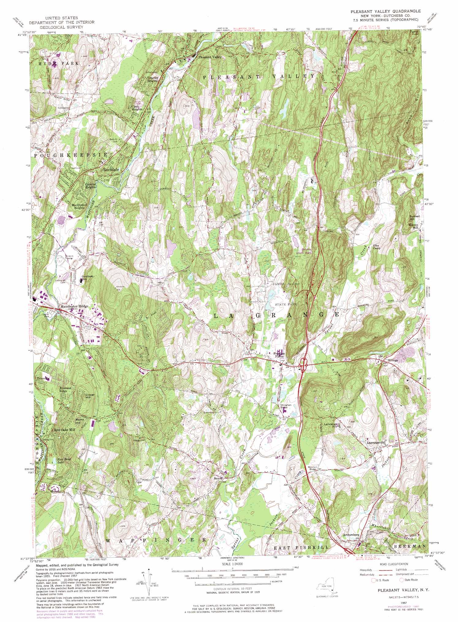
Pleasant Valley Topo Map New York
To zoom in, hover over the map of Pleasant Valley
USGS Topo Quad 41073f7 - 1:24,000 scale
| Topo Map Name: | Pleasant Valley |
| USGS Topo Quad ID: | 41073f7 |
| Print Size: | ca. 21 1/4" wide x 27" high |
| Southeast Coordinates: | 41.625° N latitude / 73.75° W longitude |
| Map Center Coordinates: | 41.6875° N latitude / 73.8125° W longitude |
| U.S. State: | NY |
| Filename: | o41073f7.jpg |
| Download Map JPG Image: | Pleasant Valley topo map 1:24,000 scale |
| Map Type: | Topographic |
| Topo Series: | 7.5´ |
| Map Scale: | 1:24,000 |
| Source of Map Images: | United States Geological Survey (USGS) |
| Alternate Map Versions: |
Pleasant Valley NY 1957, updated 1958 Download PDF Buy paper map Pleasant Valley NY 1957, updated 1965 Download PDF Buy paper map Pleasant Valley NY 1957, updated 1982 Download PDF Buy paper map Pleasant Valley NY 2010 Download PDF Buy paper map Pleasant Valley NY 2013 Download PDF Buy paper map Pleasant Valley NY 2016 Download PDF Buy paper map |
1:24,000 Topo Quads surrounding Pleasant Valley
Kingston West |
Kingston East |
Rock City |
Pine Plains |
Millerton |
Rosendale |
Hyde Park |
Salt Point |
Millbrook |
Amenia |
Clintondale |
Poughkeepsie |
Pleasant Valley |
Verbank |
Dover Plains |
Newburgh |
Wappingers Falls |
Hopewell Junction |
Poughquag |
Pawling |
Cornwall |
West Point |
Oscawana Lake |
Lake Carmel |
Brewster |
> Back to 41073e1 at 1:100,000 scale
> Back to 41072a1 at 1:250,000 scale
> Back to U.S. Topo Maps home
Pleasant Valley topo map: Gazetteer
Pleasant Valley: Bridges
Montfor Bridge elevation 97m 318′Stringham Bridge elevation 94m 308′
Pleasant Valley: Lakes
East Bend Lake elevation 54m 177′Pleasant Valley: Parks
James Baird State Park elevation 100m 328′Taconic-Hereford State Multiple Use Area elevation 186m 610′
Pleasant Valley: Populated Places
Arthursburg elevation 102m 334′Billings elevation 123m 403′
Clark Heights elevation 87m 285′
Colonial Heights elevation 76m 249′
Ennis Mobile Home Park elevation 67m 219′
Feller Mobile Home Park elevation 69m 226′
Freedom Plains elevation 96m 314′
Lagrangeville elevation 109m 357′
MacDonnell Heights elevation 66m 216′
Manchester Bridge elevation 46m 150′
Noxon elevation 91m 298′
Pleasant Valley elevation 57m 187′
Red Oaks Mill elevation 51m 167′
Rochdale elevation 61m 200′
Rombout Ridge elevation 57m 187′
Shady Brook elevation 45m 147′
Timothy Heights elevation 94m 308′
Titusville elevation 47m 154′
Pleasant Valley: Streams
Jackson Creek elevation 85m 278′Pleasant Valley: Summits
Clover Hill elevation 112m 367′Merry Hill elevation 107m 351′
Sunset Hill elevation 189m 620′
Pleasant Valley: Valleys
Pond Gut elevation 113m 370′Pleasant Valley digital topo map on disk
Buy this Pleasant Valley topo map showing relief, roads, GPS coordinates and other geographical features, as a high-resolution digital map file on DVD:
New York, Vermont, Connecticut & Western Massachusetts
Buy digital topo maps: New York, Vermont, Connecticut & Western Massachusetts