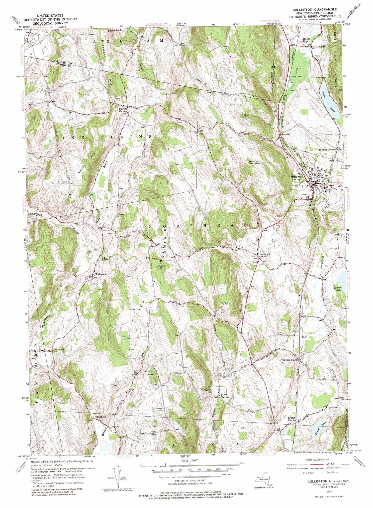
Millerton Topo Map New York
To zoom in, hover over the map of Millerton
USGS Topo Quad 41073h5 - 1:24,000 scale
| Topo Map Name: | Millerton |
| USGS Topo Quad ID: | 41073h5 |
| Print Size: | ca. 21 1/4" wide x 27" high |
| Southeast Coordinates: | 41.875° N latitude / 73.5° W longitude |
| Map Center Coordinates: | 41.9375° N latitude / 73.5625° W longitude |
| U.S. States: | NY, CT |
| Filename: | o41073h5.jpg |
| Download Map JPG Image: | Millerton topo map 1:24,000 scale |
| Map Type: | Topographic |
| Topo Series: | 7.5´ |
| Map Scale: | 1:24,000 |
| Source of Map Images: | United States Geological Survey (USGS) |
| Alternate Map Versions: |
Millerton NY 1955, updated 1957 Download PDF Buy paper map Millerton NY 1955, updated 1965 Download PDF Buy paper map Millerton NY 1955, updated 1988 Download PDF Buy paper map Millerton NY 1955, updated 1988 Download PDF Buy paper map Millerton NY 2010 Download PDF Buy paper map Millerton NY 2013 Download PDF Buy paper map Millerton NY 2016 Download PDF Buy paper map |
1:24,000 Topo Quads surrounding Millerton
Hudson South |
Claverack |
Hillsdale |
Great Barrington |
|
Clermont |
Ancram |
Copake |
Ashley Falls |
|
Rock City |
Pine Plains |
Millerton |
Sharon |
South Canaan |
Salt Point |
Millbrook |
Amenia |
Ellsworth |
Cornwall |
Pleasant Valley |
Verbank |
Dover Plains |
Kent |
New Preston |
> Back to 41073e1 at 1:100,000 scale
> Back to 41072a1 at 1:250,000 scale
> Back to U.S. Topo Maps home
Millerton topo map: Gazetteer
Millerton: Lakes
Dewitt Pond elevation 182m 597′Round Pond elevation 190m 623′
Rudd Pond elevation 240m 787′
Millerton: Parks
Coleman Station Historic District elevation 182m 597′Millerton: Populated Places
Coleman Station elevation 182m 597′Irondale elevation 222m 728′
Millerton elevation 216m 708′
Mount Riga elevation 245m 803′
Northeast elevation 383m 1256′
Northeast Center elevation 212m 695′
Pulvers Corners elevation 245m 803′
Scenic View Trailer Park elevation 242m 793′
Sharon Station elevation 188m 616′
Shekomeko elevation 193m 633′
Smithfield elevation 241m 790′
Spencer Corners elevation 257m 843′
Millerton: Post Offices
North East Post Office elevation 216m 708′Millerton: Streams
Bean River elevation 169m 554′Kelsey Brook elevation 206m 675′
Sawmill Brook elevation 223m 731′
Millerton: Summits
McGee Hill elevation 323m 1059′Prospect Hill elevation 314m 1030′
Shults Hill elevation 334m 1095′
Silver Mountain elevation 427m 1400′
Winchell Mountain elevation 403m 1322′
Millerton digital topo map on disk
Buy this Millerton topo map showing relief, roads, GPS coordinates and other geographical features, as a high-resolution digital map file on DVD:
New York, Vermont, Connecticut & Western Massachusetts
Buy digital topo maps: New York, Vermont, Connecticut & Western Massachusetts