Park Ridge Topo Map New Jersey
To zoom in, hover over the map of Park Ridge
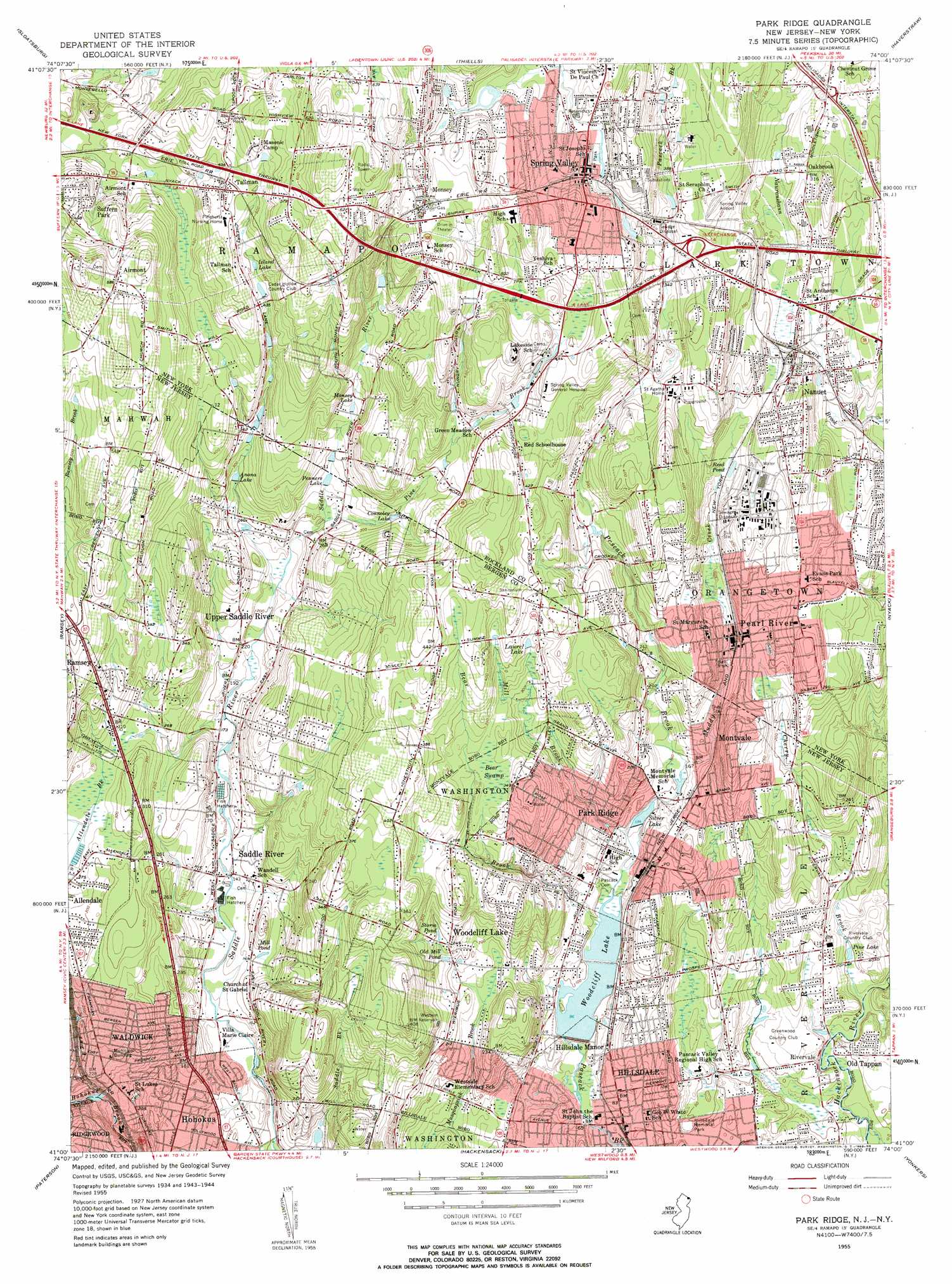
USGS Topo Quad 41074a1 - 1:24,000 scale
| Topo Map Name: | Park Ridge |
| USGS Topo Quad ID: | 41074a1 |
| Print Size: | ca. 21 1/4" wide x 27" high |
| Southeast Coordinates: | 41° N latitude / 74° W longitude |
| Map Center Coordinates: | 41.0625° N latitude / 74.0625° W longitude |
| U.S. States: | NJ, NY |
| Filename: | o41074a1.jpg |
| Download Map JPG Image: | Park Ridge topo map 1:24,000 scale |
| Map Type: | Topographic |
| Topo Series: | 7.5´ |
| Map Scale: | 1:24,000 |
| Source of Map Images: | United States Geological Survey (USGS) |
| Alternate Map Versions: |
Park Ridge NJ 1934 Download PDF Buy paper map Park Ridge NJ 1955, updated 1958 Download PDF Buy paper map Park Ridge NJ 1955, updated 1963 Download PDF Buy paper map Park Ridge NJ 1995, updated 1998 Download PDF Buy paper map Park Ridge NJ 2011 Download PDF Buy paper map Park Ridge NJ 2014 Download PDF Buy paper map Park Ridge NJ 2016 Download PDF Buy paper map |
1:24,000 Topo Quads surrounding Park Ridge
Warwick |
Monroe |
Popolopen Lake |
Peekskill |
Mohegan Lake |
Greenwood Lake |
Sloatsburg |
Thiells |
Haverstraw |
Ossining |
Wanaque |
Ramsey |
Park Ridge |
Nyack |
White Plains |
Pompton Plains |
Paterson |
Hackensack |
Yonkers |
Mount Vernon |
Caldwell |
Orange |
Weehawken |
Central Park |
Flushing |
> Back to 41074a1 at 1:100,000 scale
> Back to 41074a1 at 1:250,000 scale
> Back to U.S. Topo Maps home
Park Ridge topo map: Gazetteer
Park Ridge: Airports
Garfield Heliport elevation 67m 219′Ramapo Heliport elevation 127m 416′
Park Ridge: Crossings
Interchange 14 elevation 112m 367′Interchange 14A elevation 129m 423′
Interchange 14B elevation 140m 459′
Interchange 171 elevation 105m 344′
Interchange 172 elevation 118m 387′
Park Ridge: Dams
Woodcliff Lake Dam elevation 30m 98′Park Ridge: Lakes
Coles Pond elevation 56m 183′Reed Pond elevation 81m 265′
Park Ridge: Parks
Capital Park elevation 105m 344′Dexter Park elevation 93m 305′
Hillsdale Memorial Park elevation 17m 55′
Lorna Lane Park elevation 130m 426′
Pascack Brook Town Park elevation 80m 262′
Pine Brook Farms Park elevation 97m 318′
Rindlaub Park elevation 41m 134′
Park Ridge: Populated Places
Airmont elevation 178m 583′Chestnut Ridge elevation 130m 426′
Chestnut Ridge elevation 126m 413′
Hillsdale elevation 18m 59′
Hillsdale Manor elevation 32m 104′
Kaser elevation 165m 541′
Monsey elevation 167m 547′
Montvale elevation 96m 314′
Mount Pleasant elevation 105m 344′
Nanuet elevation 91m 298′
Oakbrook elevation 97m 318′
Park Ridge elevation 50m 164′
Pearl River elevation 73m 239′
Rivervale elevation 20m 65′
Saddle River elevation 47m 154′
Spring Valley elevation 135m 442′
Spring Valley Village elevation 116m 380′
Suffern Park elevation 148m 485′
Tallman elevation 151m 495′
Upper Montvale elevation 133m 436′
Upper Montvale elevation 115m 377′
Upper Saddle River elevation 67m 219′
Villa Marie Claire elevation 35m 114′
Waldwick elevation 76m 249′
Woodcliff Lake elevation 75m 246′
Park Ridge: Post Offices
Spring Valley Post Office elevation 138m 452′Park Ridge: Reservoirs
Anona Lake elevation 85m 278′Connoley Lake elevation 89m 291′
Island Lake elevation 136m 446′
Lake Tappan elevation 12m 39′
Laurel Lake elevation 107m 351′
Mill Pond elevation 45m 147′
Monsey Lake elevation 100m 328′
Moores Pond elevation 45m 147′
Old Mill Pond elevation 64m 209′
Penners Lake elevation 85m 278′
Pine Lake elevation 14m 45′
Silver Lake elevation 40m 131′
Storm Pond elevation 75m 246′
Western Reservoir elevation 83m 272′
Woodcliff Lake elevation 30m 98′
Park Ridge: Streams
Bear Brook elevation 30m 98′Cherry Brook elevation 10m 32′
Cherry Brook elevation 9m 29′
Hillsdale Brook elevation 6m 19′
Holdrum Brook elevation 12m 39′
Mill Brook elevation 50m 164′
Muddy Brook elevation 45m 147′
Muddy Brook elevation 45m 147′
Pine Brook elevation 75m 246′
Pine Brook elevation 75m 246′
Pleasant Brook elevation 49m 160′
West Branch Saddle River elevation 61m 200′
Park Ridge: Summits
Spook Rock elevation 168m 551′Park Ridge: Swamps
Bear Swamp elevation 96m 314′Park Ridge: Valleys
Saddle River Valley elevation 32m 104′Park Ridge digital topo map on disk
Buy this Park Ridge topo map showing relief, roads, GPS coordinates and other geographical features, as a high-resolution digital map file on DVD:
New York, Vermont, Connecticut & Western Massachusetts
Buy digital topo maps: New York, Vermont, Connecticut & Western Massachusetts