Newfoundland Topo Map New Jersey
To zoom in, hover over the map of Newfoundland
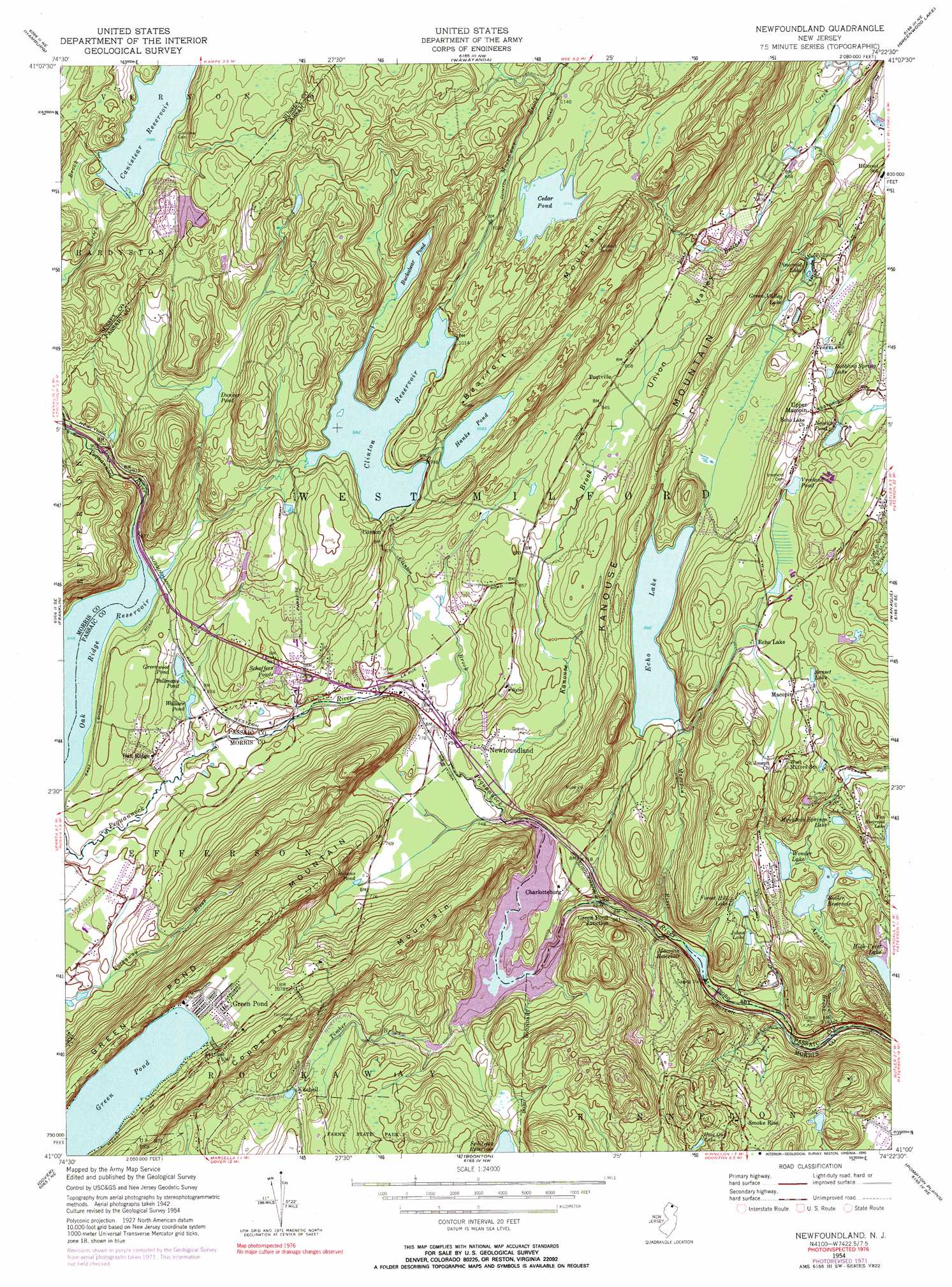
USGS Topo Quad 41074a4 - 1:24,000 scale
| Topo Map Name: | Newfoundland |
| USGS Topo Quad ID: | 41074a4 |
| Print Size: | ca. 21 1/4" wide x 27" high |
| Southeast Coordinates: | 41° N latitude / 74.375° W longitude |
| Map Center Coordinates: | 41.0625° N latitude / 74.4375° W longitude |
| U.S. State: | NJ |
| Filename: | o41074a4.jpg |
| Download Map JPG Image: | Newfoundland topo map 1:24,000 scale |
| Map Type: | Topographic |
| Topo Series: | 7.5´ |
| Map Scale: | 1:24,000 |
| Source of Map Images: | United States Geological Survey (USGS) |
| Alternate Map Versions: |
Newfoundland NJ 1954, updated 1955 Download PDF Buy paper map Newfoundland NJ 1954, updated 1960 Download PDF Buy paper map Newfoundland NJ 1954, updated 1967 Download PDF Buy paper map Newfoundland NJ 1954, updated 1973 Download PDF Buy paper map Newfoundland NJ 1954, updated 1974 Download PDF Buy paper map Newfoundland NJ 1954, updated 1990 Download PDF Buy paper map Newfoundland NJ 1997, updated 1998 Download PDF Buy paper map Newfoundland NJ 2011 Download PDF Buy paper map Newfoundland NJ 2014 Download PDF Buy paper map Newfoundland NJ 2016 Download PDF Buy paper map |
1:24,000 Topo Quads surrounding Newfoundland
Port Jervis South |
Unionville |
Pine Island |
Warwick |
Monroe |
Branchville |
Hamburg |
Wawayanda |
Greenwood Lake |
Sloatsburg |
Newton East |
Franklin |
Newfoundland |
Wanaque |
Ramsey |
Stanhope |
Dover |
Boonton |
Pompton Plains |
Paterson |
Chester |
Mendham |
Morristown |
Caldwell |
Orange |
> Back to 41074a1 at 1:100,000 scale
> Back to 41074a1 at 1:250,000 scale
> Back to U.S. Topo Maps home
Newfoundland topo map: Gazetteer
Newfoundland: Airports
Idylease Helistop elevation 269m 882′Newfoundland: Dams
Apshawa Main Dam elevation 226m 741′Cannistear Reservoir Dam Number One elevation 329m 1079′
Cannistear Reservoir Dam Number Two elevation 330m 1082′
Cantys Lake Dam elevation 252m 826′
Cedar Pond Dam elevation 340m 1115′
Charlotteburg Dam elevation 217m 711′
Clinton Reservoir Dam elevation 299m 980′
Echo Lake Spillway Dam elevation 272m 892′
Hanks Pond Dam elevation 312m 1023′
Macopin Reservoir Dam elevation 177m 580′
Nosenzo Pond Dam elevation 299m 980′
Pinecrest Dam elevation 268m 879′
Wonder Lake Dam elevation 238m 780′
Newfoundland: Lakes
Browns Pond elevation 232m 761′Bubbling Spring Lake elevation 296m 971′
Buckabear Pond elevation 301m 987′
Dunker Pond elevation 307m 1007′
Genaders Pond elevation 301m 987′
Green Pond elevation 317m 1040′
Green Valley Lake elevation 276m 905′
Greenwood Pond elevation 255m 836′
Hoot Owl Lake elevation 274m 898′
Johns Lake elevation 210m 688′
Mountain Springs Lake elevation 259m 849′
Pinecrest Lake elevation 266m 872′
Reflection Lake elevation 196m 643′
Sunset Lake elevation 310m 1017′
Tallmans Pond elevation 252m 826′
Vreeland Pond elevation 307m 1007′
Wallace Pond elevation 248m 813′
Newfoundland: Parks
Farny State Park elevation 288m 944′Newfoundland: Populated Places
Charlotteburg elevation 232m 761′Clinton elevation 280m 918′
Davenport elevation 284m 931′
Echo Lake elevation 298m 977′
Green Lake elevation 285m 935′
Green Pond elevation 321m 1053′
Green Pond Junction elevation 208m 682′
Kitchell elevation 281m 921′
Macopin elevation 306m 1003′
Newfoundland elevation 232m 761′
Oak Ridge elevation 268m 879′
Postville elevation 252m 826′
Upper Macopin elevation 325m 1066′
Newfoundland: Reservoirs
Butler Reservoir elevation 226m 741′Canistear Reservoir elevation 329m 1079′
Cantys Lake elevation 252m 826′
Cedar Pond elevation 340m 1115′
Charlotteburg Reservoir elevation 217m 711′
Cliffwood Lake elevation 360m 1181′
Clinton Reservoir elevation 299m 980′
Echo Lake elevation 275m 902′
Forest Hill Lake elevation 214m 702′
Hanks Pond elevation 312m 1023′
Hines Pond elevation 194m 636′
Macopin Reservoir elevation 177m 580′
Nosenzo Pond elevation 299m 980′
Pettet Pond elevation 199m 652′
Schaffers Ponds elevation 266m 872′
Snow Valley Pond elevation 254m 833′
Triangle Lake elevation 283m 928′
Wonder Lake elevation 238m 780′
Newfoundland: Streams
Apshawa Brook elevation 150m 492′Clinton Brook elevation 231m 757′
Dunker Brook elevation 256m 839′
Echo Lake Channel elevation 193m 633′
Kanouse Brook elevation 225m 738′
Macopin River elevation 180m 590′
Matthews Brook elevation 234m 767′
Mossmans Brook elevation 304m 997′
Timber Brook elevation 222m 728′
Newfoundland: Summits
Copperas Mountain elevation 373m 1223′Kanouse Mountain elevation 361m 1184′
Newfoundland: Valleys
Clinton Brook Valley elevation 349m 1145′Union Valley elevation 235m 770′
Newfoundland digital topo map on disk
Buy this Newfoundland topo map showing relief, roads, GPS coordinates and other geographical features, as a high-resolution digital map file on DVD:
New York, Vermont, Connecticut & Western Massachusetts
Buy digital topo maps: New York, Vermont, Connecticut & Western Massachusetts