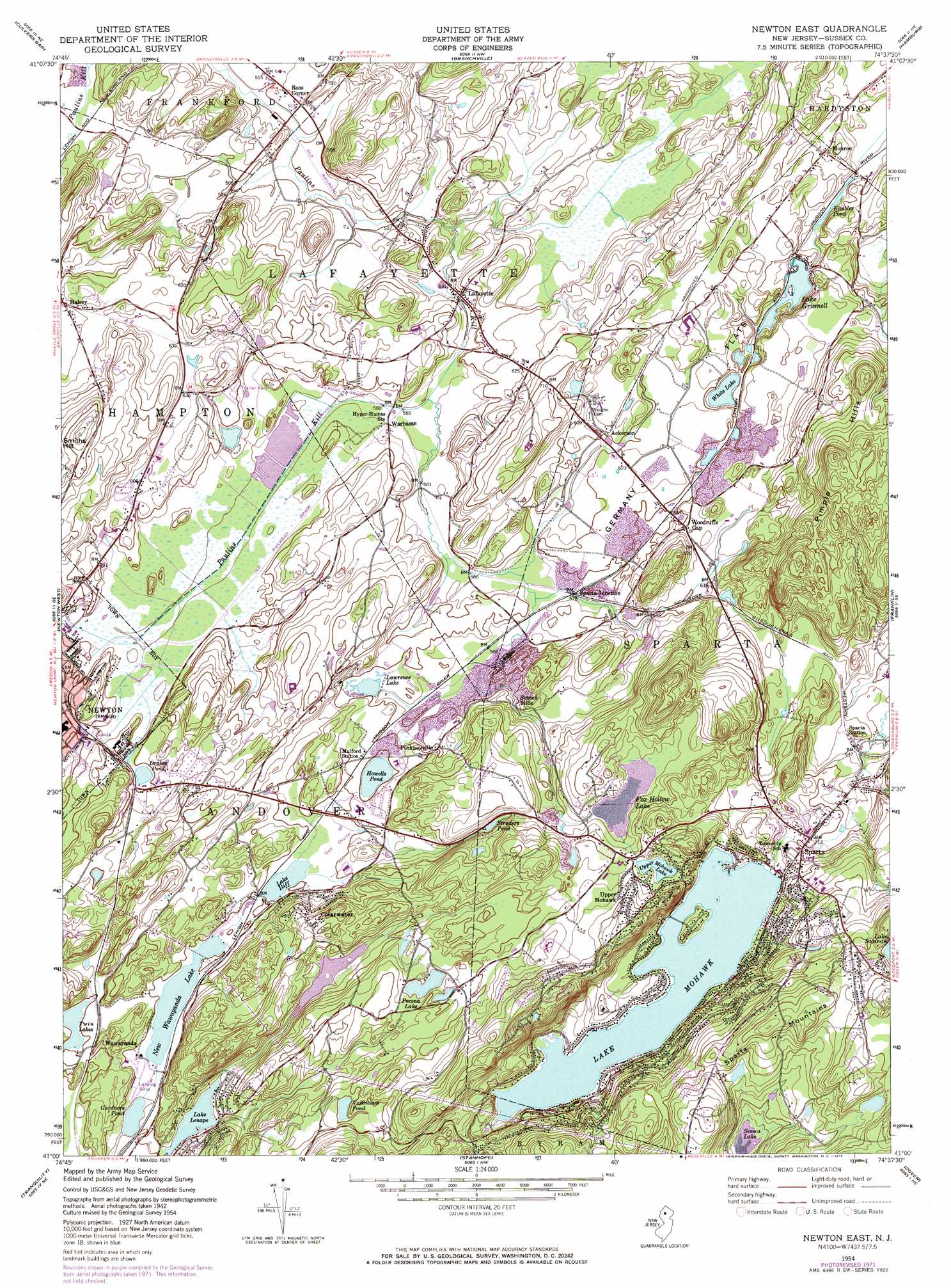
Newton East Topo Map New Jersey
To zoom in, hover over the map of Newton East
USGS Topo Quad 41074a6 - 1:24,000 scale
| Topo Map Name: | Newton East |
| USGS Topo Quad ID: | 41074a6 |
| Print Size: | ca. 21 1/4" wide x 27" high |
| Southeast Coordinates: | 41° N latitude / 74.625° W longitude |
| Map Center Coordinates: | 41.0625° N latitude / 74.6875° W longitude |
| U.S. State: | NJ |
| Filename: | o41074a6.jpg |
| Download Map JPG Image: | Newton East topo map 1:24,000 scale |
| Map Type: | Topographic |
| Topo Series: | 7.5´ |
| Map Scale: | 1:24,000 |
| Source of Map Images: | United States Geological Survey (USGS) |
| Alternate Map Versions: |
Newton East NJ 1954, updated 1955 Download PDF Buy paper map Newton East NJ 1954, updated 1964 Download PDF Buy paper map Newton East NJ 1954, updated 1971 Download PDF Buy paper map Newton East NJ 1954, updated 1974 Download PDF Buy paper map Newton East NJ 1954, updated 1974 Download PDF Buy paper map Newton East NJ 2011 Download PDF Buy paper map Newton East NJ 2014 Download PDF Buy paper map Newton East NJ 2016 Download PDF Buy paper map |
1:24,000 Topo Quads surrounding Newton East
Edgemere |
Milford |
Port Jervis South |
Unionville |
Pine Island |
Lake Maskenozha |
Culvers Gap |
Branchville |
Hamburg |
Wawayanda |
Flatbrookville |
Newton West |
Newton East |
Franklin |
Newfoundland |
Blairstown |
Tranquility |
Stanhope |
Dover |
Boonton |
Washington |
Hackettstown |
Chester |
Mendham |
Morristown |
> Back to 41074a1 at 1:100,000 scale
> Back to 41074a1 at 1:250,000 scale
> Back to U.S. Topo Maps home
Newton East topo map: Gazetteer
Newton East: Airports
Aeroflex-Andover Airport elevation 178m 583′Newton East: Dams
Emilio Perona Dam elevation 228m 748′Fox Hollow Dam elevation 221m 725′
Gardners Pond Dam elevation 175m 574′
Lake Grinnell Dam elevation 173m 567′
Lake Lenape Dam elevation 187m 613′
Lake Mohawk Dam elevation 224m 734′
Lake Saginaw Dam elevation 307m 1007′
Lawrence Dam elevation 177m 580′
New Wawayanda Lake Dam elevation 178m 583′
Reynolds Lake Dam elevation 177m 580′
Upper Mohawk Lake Dam elevation 245m 803′
Newton East: Flats
Germany Flats elevation 190m 623′Newton East: Lakes
Beisers Pond elevation 280m 918′Drakes Pond elevation 182m 597′
Fowlers Pond elevation 291m 954′
Howells Pond elevation 180m 590′
Kimbles Pond elevation 169m 554′
Laidlaws Pond elevation 321m 1053′
Lake Grinnell elevation 169m 554′
Lake Iliff elevation 181m 593′
Seneca Lake elevation 257m 843′
Straders Pond elevation 211m 692′
Twin Lakes elevation 178m 583′
Upper Lake Mohawk elevation 244m 800′
White Lake elevation 175m 574′
Newton East: Parks
Newton Playground (historical) elevation 175m 574′Ungerman Field elevation 214m 702′
Newton East: Populated Places
Ackerson elevation 183m 600′Clearwater elevation 215m 705′
Halsey elevation 187m 613′
Houses Corner elevation 191m 626′
Lafayette elevation 170m 557′
Lake Mohawk elevation 229m 751′
Monroe elevation 176m 577′
Pinkneyville elevation 182m 597′
Ross Corner elevation 157m 515′
Sparta elevation 228m 748′
Sparta Junction elevation 177m 580′
Sussex Mills elevation 188m 616′
Upper Mohawk elevation 264m 866′
Warbasse elevation 170m 557′
Wawayanda elevation 180m 590′
Woodruffs Gap elevation 189m 620′
Newton East: Ranges
Pimple Hills elevation 342m 1122′Newton East: Reservoirs
Clearwater Lake elevation 204m 669′Fox Hollow Lake elevation 221m 725′
Gardners Pond elevation 175m 574′
Lake Lenape elevation 188m 616′
Lake Mohawk elevation 221m 725′
Lawrence Lake elevation 177m 580′
New Wawayanda Lake elevation 178m 583′
Perona Lake elevation 228m 748′
Reynolds Lake elevation 177m 580′
Upper Mohawk Lake elevation 245m 803′
Newton East: Summits
Smiths Hill elevation 263m 862′Newton East digital topo map on disk
Buy this Newton East topo map showing relief, roads, GPS coordinates and other geographical features, as a high-resolution digital map file on DVD:
New York, Vermont, Connecticut & Western Massachusetts
Buy digital topo maps: New York, Vermont, Connecticut & Western Massachusetts