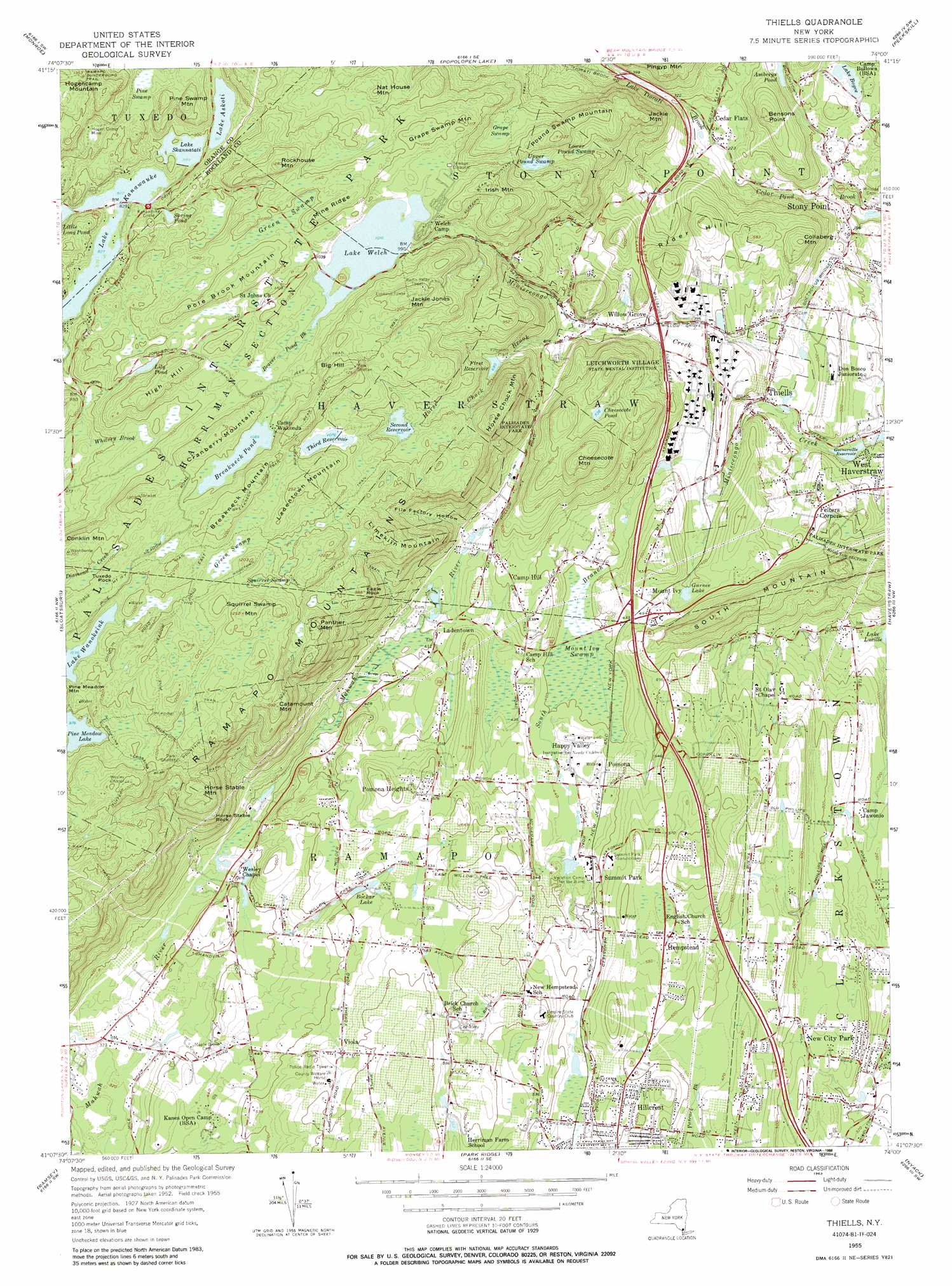
Thiells Topo Map New York
To zoom in, hover over the map of Thiells
USGS Topo Quad 41074b1 - 1:24,000 scale
| Topo Map Name: | Thiells |
| USGS Topo Quad ID: | 41074b1 |
| Print Size: | ca. 21 1/4" wide x 27" high |
| Southeast Coordinates: | 41.125° N latitude / 74° W longitude |
| Map Center Coordinates: | 41.1875° N latitude / 74.0625° W longitude |
| U.S. State: | NY |
| Filename: | o41074b1.jpg |
| Download Map JPG Image: | Thiells topo map 1:24,000 scale |
| Map Type: | Topographic |
| Topo Series: | 7.5´ |
| Map Scale: | 1:24,000 |
| Source of Map Images: | United States Geological Survey (USGS) |
| Alternate Map Versions: |
Thiells NY 1955, updated 1957 Download PDF Buy paper map Thiells NY 1955, updated 1963 Download PDF Buy paper map Thiells NY 1955, updated 1973 Download PDF Buy paper map Thiells NY 1955, updated 1988 Download PDF Buy paper map Thiells NY 2010 Download PDF Buy paper map Thiells NY 2013 Download PDF Buy paper map Thiells NY 2016 Download PDF Buy paper map |
1:24,000 Topo Quads surrounding Thiells
Goshen |
Maybrook |
Cornwall |
West Point |
Oscawana Lake |
Warwick |
Monroe |
Popolopen Lake |
Peekskill |
Mohegan Lake |
Greenwood Lake |
Sloatsburg |
Thiells |
Haverstraw |
Ossining |
Wanaque |
Ramsey |
Park Ridge |
Nyack |
White Plains |
Pompton Plains |
Paterson |
Hackensack |
Yonkers |
Mount Vernon |
> Back to 41074a1 at 1:100,000 scale
> Back to 41074a1 at 1:250,000 scale
> Back to U.S. Topo Maps home
Thiells topo map: Gazetteer
Thiells: Crossings
Interchange 11 elevation 151m 495′Interchange 12 elevation 157m 515′
Interchange 13 elevation 134m 439′
Interchange 14 elevation 115m 377′
Interchange 15 elevation 112m 367′
Interchange 16 elevation 122m 400′
Thiells: Lakes
Ambreys Pond elevation 83m 272′Bockar Lake elevation 152m 498′
Cheesecote Pond elevation 225m 738′
Gurnee Lake elevation 125m 410′
Lake Wanoksink elevation 316m 1036′
Spring Pond elevation 266m 872′
Thiells: Mines
Hogen Camp Mine elevation 320m 1049′Thiells: Parks
Cheesecote Mountain Town Park elevation 259m 849′Fairway Park elevation 153m 501′
Kings Gate Park elevation 103m 337′
Mount Ivy County Park elevation 121m 396′
South Mountain County Park elevation 201m 659′
Thiells: Populated Places
Camp Hill elevation 166m 544′Cedar Flats elevation 69m 226′
Felters Corners elevation 121m 396′
Fountain Head Mobile Home Park elevation 134m 439′
Happy Valley elevation 133m 436′
Hillcrest elevation 156m 511′
Ladentown elevation 128m 419′
Mazzaleone Park elevation 143m 469′
Montebello elevation 97m 318′
Mount Ivy elevation 140m 459′
New City Park elevation 74m 242′
New Hampstead elevation 175m 574′
New Hempstead elevation 177m 580′
New Square elevation 150m 492′
Parkway Mobile Home Park elevation 139m 456′
Pomona elevation 138m 452′
Pomona Heights elevation 174m 570′
Quaker Park elevation 131m 429′
Summit Park elevation 152m 498′
Thiells elevation 84m 275′
Viola elevation 173m 567′
Wesley Hills elevation 164m 538′
Willow Grove elevation 125m 410′
Thiells: Ranges
Ramapo Mountains elevation 317m 1040′Thiells: Reservoirs
Breakneck Pond elevation 329m 1079′First Reservoir elevation 198m 649′
Garnerville Reservoir elevation 64m 209′
Lake Askoti elevation 277m 908′
Lake Boyce elevation 77m 252′
Lake Skannatati elevation 271m 889′
Lake Welch elevation 303m 994′
Lily Pond elevation 302m 990′
Second Reservoir elevation 284m 931′
Third Reservoir elevation 323m 1059′
Thiells: Ridges
Mine Ridge elevation 353m 1158′Thiells: Streams
Beaver Pond Brook elevation 308m 1010′Horse Chock Brook elevation 134m 439′
Lake Tiorati Brook elevation 67m 219′
South Branch Minisceongo Creek elevation 107m 351′
Thiells: Summits
Bensons Point elevation 160m 524′Big Hill elevation 374m 1227′
Breakneck Mountain elevation 384m 1259′
Catamount Mountain elevation 325m 1066′
Cheesecote Mountain elevation 296m 971′
Collaberg Mountain elevation 180m 590′
Conklin Mountain elevation 365m 1197′
Cranberry Mountain elevation 366m 1200′
Eagle Rock elevation 292m 958′
Grape Swamp Mountain elevation 344m 1128′
High Hill elevation 361m 1184′
Hogencamp Mountain elevation 407m 1335′
Horse Chock Mountain elevation 330m 1082′
Horse Stable Mountain elevation 325m 1066′
Horse Stable Rock elevation 242m 793′
Irish Mountain elevation 346m 1135′
Jackie Jones Mountain elevation 383m 1256′
Jackie Mountain elevation 252m 826′
Ladentown Mountain elevation 378m 1240′
Limekiln Mountain elevation 342m 1122′
Nat House Mountain elevation 325m 1066′
Panther Mountain elevation 334m 1095′
Pine Swamp Mountain elevation 355m 1164′
Pole Brook Mountain elevation 360m 1181′
Pound Swamp Mountain elevation 306m 1003′
Rider Hill elevation 193m 633′
Rockhouse Mountain elevation 387m 1269′
Squirrel Swamp Mountain elevation 378m 1240′
Tuxedo Rock elevation 358m 1174′
Thiells: Swamps
Grape Swamp elevation 252m 826′Green Swamp elevation 327m 1072′
Green Swamp elevation 339m 1112′
Lower Pound Swamp elevation 237m 777′
Mount Ivy Swamp elevation 119m 390′
Pine Swamp elevation 308m 1010′
Squirrel Swamp elevation 335m 1099′
Upper Pound Swamp elevation 254m 833′
Thiells: Trails
Breakneck Ridge Trail elevation 375m 1230′Conklins Crossing elevation 322m 1056′
Sherwood Path elevation 329m 1079′
Suffern-Bear Mountain Trail elevation 333m 1092′
Torne Mount Ivy Trail elevation 352m 1154′
Woodtown Trail elevation 336m 1102′
Thiells: Valleys
File Factory Hollow elevation 147m 482′Thiells digital topo map on disk
Buy this Thiells topo map showing relief, roads, GPS coordinates and other geographical features, as a high-resolution digital map file on DVD:
New York, Vermont, Connecticut & Western Massachusetts
Buy digital topo maps: New York, Vermont, Connecticut & Western Massachusetts