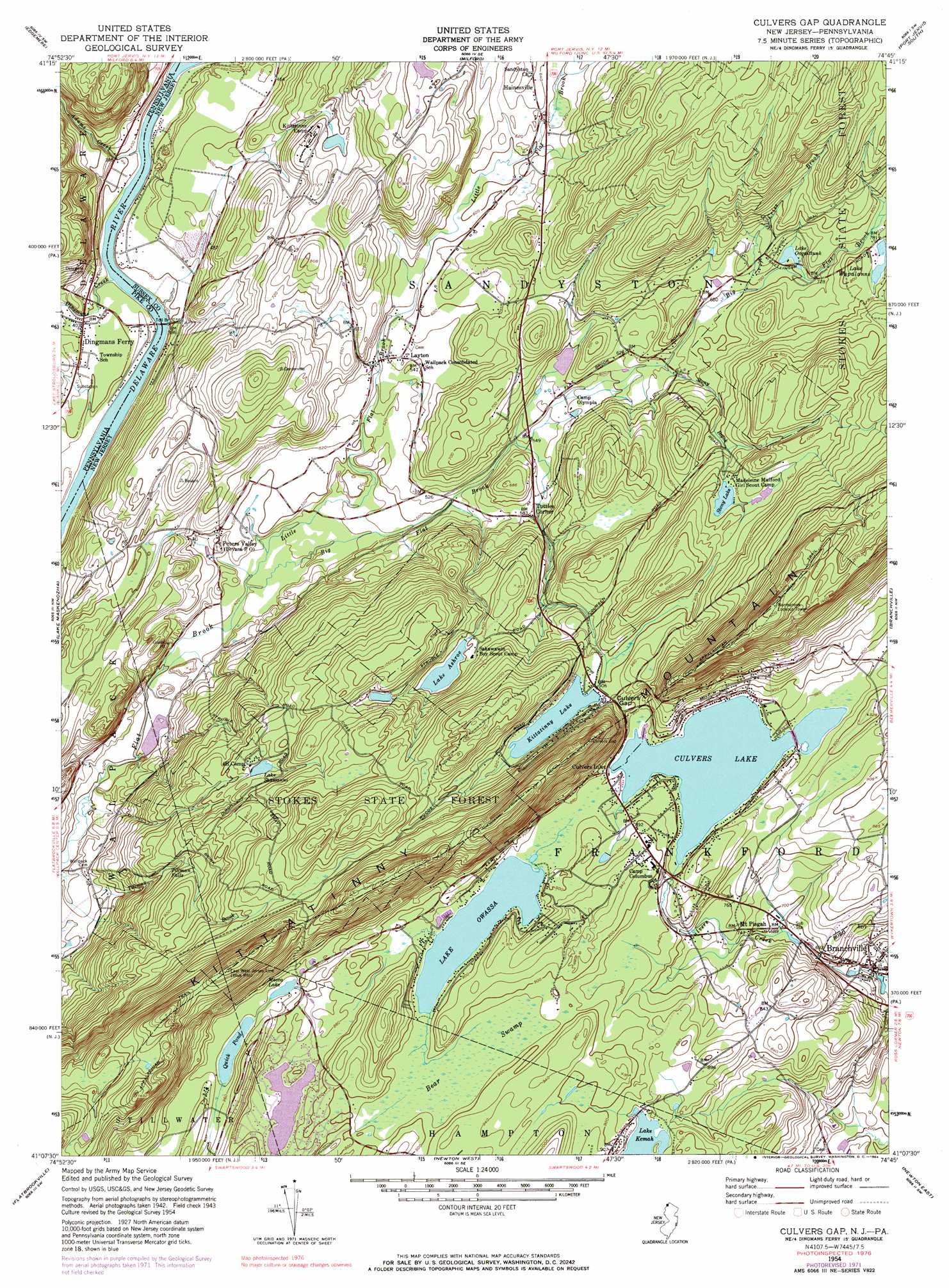
Culvers Gap Topo Map New Jersey
To zoom in, hover over the map of Culvers Gap
USGS Topo Quad 41074b7 - 1:24,000 scale
| Topo Map Name: | Culvers Gap |
| USGS Topo Quad ID: | 41074b7 |
| Print Size: | ca. 21 1/4" wide x 27" high |
| Southeast Coordinates: | 41.125° N latitude / 74.75° W longitude |
| Map Center Coordinates: | 41.1875° N latitude / 74.8125° W longitude |
| U.S. States: | NJ, PA |
| Filename: | o41074b7.jpg |
| Download Map JPG Image: | Culvers Gap topo map 1:24,000 scale |
| Map Type: | Topographic |
| Topo Series: | 7.5´ |
| Map Scale: | 1:24,000 |
| Source of Map Images: | United States Geological Survey (USGS) |
| Alternate Map Versions: |
Culvers Gap NJ 1954, updated 1956 Download PDF Buy paper map Culvers Gap NJ 1954, updated 1962 Download PDF Buy paper map Culvers Gap NJ 1954, updated 1968 Download PDF Buy paper map Culvers Gap NJ 1954, updated 1974 Download PDF Buy paper map Culvers Gap NJ 1954, updated 1984 Download PDF Buy paper map Culvers Gap NJ 2011 Download PDF Buy paper map Culvers Gap NJ 2014 Download PDF Buy paper map Culvers Gap NJ 2016 Download PDF Buy paper map |
1:24,000 Topo Quads surrounding Culvers Gap
Rowland |
Shohola |
Pond Eddy |
Port Jervis North |
Otisville |
Pecks Pond |
Edgemere |
Milford |
Port Jervis South |
Unionville |
Twelvemile Pond |
Lake Maskenozha |
Culvers Gap |
Branchville |
Hamburg |
Bushkill |
Flatbrookville |
Newton West |
Newton East |
Franklin |
Portland |
Blairstown |
Tranquility |
Stanhope |
Dover |
> Back to 41074a1 at 1:100,000 scale
> Back to 41074a1 at 1:250,000 scale
> Back to U.S. Topo Maps home
Culvers Gap topo map: Gazetteer
Culvers Gap: Dams
Culvers Lake Dam elevation 258m 846′Kittatinny Camp Lake Dam elevation 210m 688′
Kittatinny Lake Dam elevation 277m 908′
Lake Ashroe Dam elevation 242m 793′
Lake Ocquittunk Dam elevation 216m 708′
Lake Owassa Dam elevation 266m 872′
Lake Robert Rooke Dam elevation 179m 587′
Quick Pond Dam elevation 283m 928′
Skellinger Dam elevation 235m 770′
Stony Lake Dam elevation 269m 882′
Culvers Gap: Falls
Tillman Falls elevation 217m 711′Culvers Gap: Forests
Stokes State Forest elevation 347m 1138′Culvers Gap: Gaps
Culvers Gap elevation 275m 902′Culvers Gap: Lakes
Lake Owassa elevation 264m 866′Mecca Lake elevation 283m 928′
Culvers Gap: Parks
Flatbrook Fish and Wildlife Management Area elevation 131m 429′Culvers Gap: Populated Places
Bevans elevation 150m 492′Branchville elevation 174m 570′
Culvers Inlet elevation 264m 866′
Dingmans Ferry elevation 124m 406′
Layton elevation 175m 574′
Mount Pisgah elevation 211m 692′
Normanook elevation 229m 751′
Tuttles Corner elevation 178m 583′
Culvers Gap: Reservoirs
Crandon Lakes elevation 260m 853′Culvers Lake elevation 258m 846′
Kittatinny Camp Lake elevation 210m 688′
Kittatinny Lake elevation 277m 908′
Lake Ashroe elevation 244m 800′
Lake Ocquittunk elevation 216m 708′
Lake Robert Rooke elevation 179m 587′
Lake Shawanni elevation 253m 830′
Lake Wapalanne elevation 234m 767′
Quick Pond elevation 283m 928′
Stony Lake elevation 269m 882′
Culvers Gap: Streams
Adams Creek elevation 114m 374′Big Flat Brook elevation 128m 419′
Criss Brook elevation 207m 679′
Dingmans Creek elevation 110m 360′
Kittatinny Creek elevation 108m 354′
Little Flat Brook elevation 128m 419′
Stony Brook elevation 194m 636′
Culvers Gap: Swamps
Bear Swamp elevation 266m 872′Culvers Gap digital topo map on disk
Buy this Culvers Gap topo map showing relief, roads, GPS coordinates and other geographical features, as a high-resolution digital map file on DVD:
New York, Vermont, Connecticut & Western Massachusetts
Buy digital topo maps: New York, Vermont, Connecticut & Western Massachusetts