Pine Island Topo Map New York
To zoom in, hover over the map of Pine Island
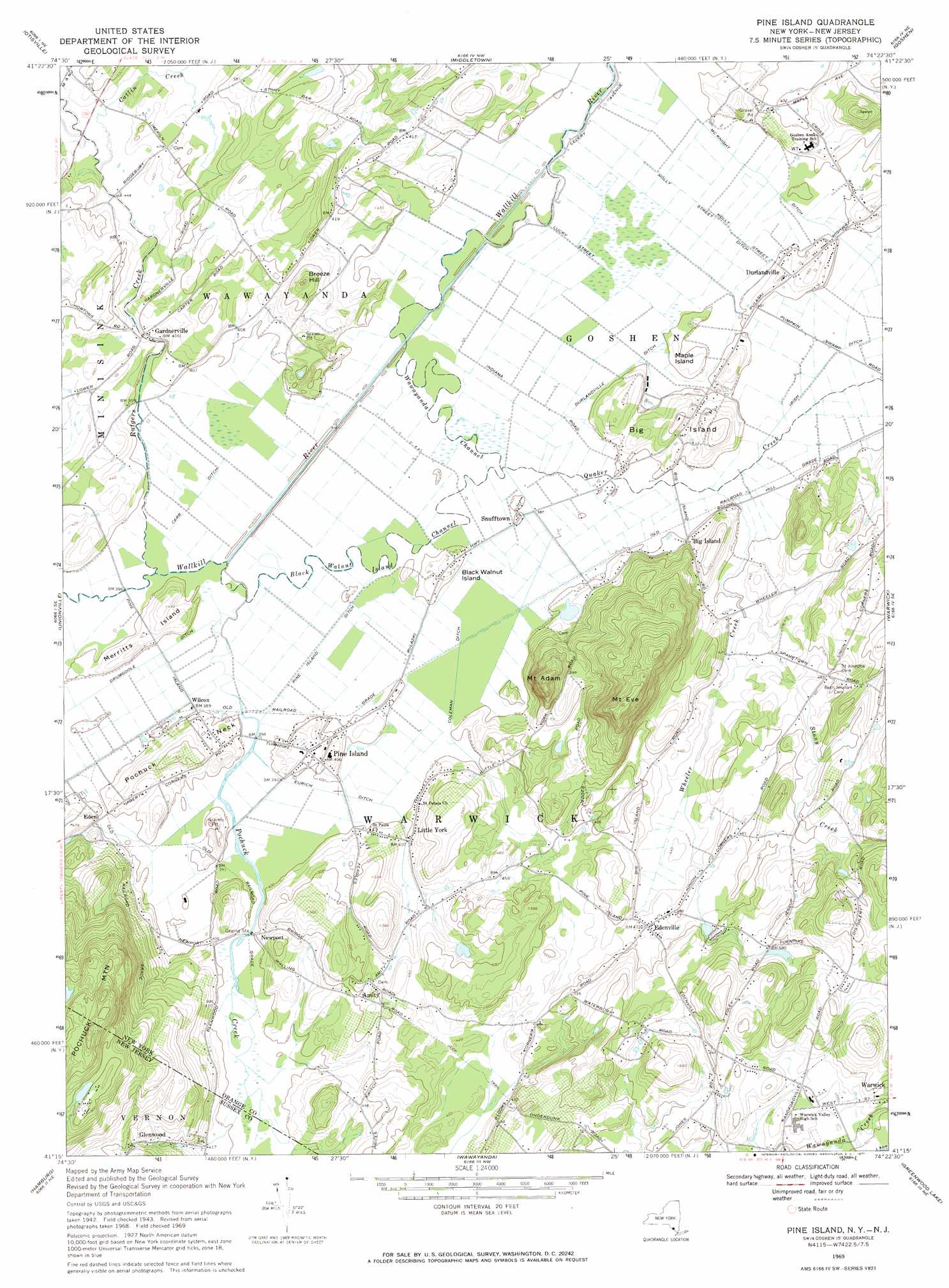
USGS Topo Quad 41074c4 - 1:24,000 scale
| Topo Map Name: | Pine Island |
| USGS Topo Quad ID: | 41074c4 |
| Print Size: | ca. 21 1/4" wide x 27" high |
| Southeast Coordinates: | 41.25° N latitude / 74.375° W longitude |
| Map Center Coordinates: | 41.3125° N latitude / 74.4375° W longitude |
| U.S. States: | NY, NJ |
| Filename: | o41074c4.jpg |
| Download Map JPG Image: | Pine Island topo map 1:24,000 scale |
| Map Type: | Topographic |
| Topo Series: | 7.5´ |
| Map Scale: | 1:24,000 |
| Source of Map Images: | United States Geological Survey (USGS) |
| Alternate Map Versions: |
Pine Island NY 1942, updated 1954 Download PDF Buy paper map Pine Island NY 1942, updated 1963 Download PDF Buy paper map Pine Island NY 1969, updated 1971 Download PDF Buy paper map Pine Island NY 2011 Download PDF Buy paper map Pine Island NY 2013 Download PDF Buy paper map Pine Island NY 2016 Download PDF Buy paper map |
1:24,000 Topo Quads surrounding Pine Island
Hartwood |
Yankee Lake |
Wurtsboro |
Pine Bush |
Walden |
Port Jervis North |
Otisville |
Middletown |
Goshen |
Maybrook |
Port Jervis South |
Unionville |
Pine Island |
Warwick |
Monroe |
Branchville |
Hamburg |
Wawayanda |
Greenwood Lake |
Sloatsburg |
Newton East |
Franklin |
Newfoundland |
Wanaque |
Ramsey |
> Back to 41074a1 at 1:100,000 scale
> Back to 41074a1 at 1:250,000 scale
> Back to U.S. Topo Maps home
Pine Island topo map: Gazetteer
Pine Island: Airports
Big Island Airport elevation 122m 400′Pine Island: Canals
Carr Ditch elevation 119m 390′Coleman Ditch elevation 120m 393′
Drumgoole Ditch elevation 120m 393′
Durlandville Ditch elevation 122m 400′
Eurich Ditch elevation 119m 390′
Holly Street Ditch elevation 119m 390′
Irish Ditch elevation 119m 390′
McKnight Ditch elevation 121m 396′
Pine Island Ditch elevation 119m 390′
Pine Island: Channels
Black Walnut Island Channel elevation 117m 383′Wawayanda Channel elevation 119m 390′
Pine Island: Dams
Denton Clark Estate Dam elevation 272m 892′Pine Island: Islands
Big Island elevation 154m 505′Black Walnut Island elevation 136m 446′
Maple Island elevation 129m 423′
Merritts Island elevation 134m 439′
Pine Island: Parks
Pine Island Town Park elevation 121m 396′Warwick Town Park elevation 154m 505′
Pine Island: Populated Places
Amity elevation 154m 505′Big Island elevation 122m 400′
Breeze Hill Estates elevation 139m 456′
Durlandville elevation 131m 429′
Eden elevation 121m 396′
Edenville elevation 144m 472′
Gardnerville elevation 131m 429′
Glenwood elevation 171m 561′
Little York elevation 125m 410′
Newport elevation 129m 423′
Pine Island elevation 125m 410′
Points of View elevation 161m 528′
Snufftown elevation 122m 400′
Wilcox elevation 120m 393′
Pine Island: Reservoirs
Louemma Lake elevation 272m 892′Pine Island: Ridges
Pochuck Neck elevation 156m 511′Pine Island: Streams
Catlin Creek elevation 134m 439′Indigot Creek elevation 134m 439′
Pochuck Creek elevation 117m 383′
Quaker Creek elevation 121m 396′
Rutgers Creek elevation 116m 380′
Stony Creek elevation 126m 413′
Wheeler Creek elevation 118m 387′
Pine Island: Summits
Breeze Hill elevation 183m 600′Mount Adam elevation 276m 905′
Mount Eve elevation 324m 1062′
Pine Island: Valleys
Vernon Valley elevation 118m 387′Pine Island digital topo map on disk
Buy this Pine Island topo map showing relief, roads, GPS coordinates and other geographical features, as a high-resolution digital map file on DVD:
New York, Vermont, Connecticut & Western Massachusetts
Buy digital topo maps: New York, Vermont, Connecticut & Western Massachusetts