Middletown Topo Map New York
To zoom in, hover over the map of Middletown
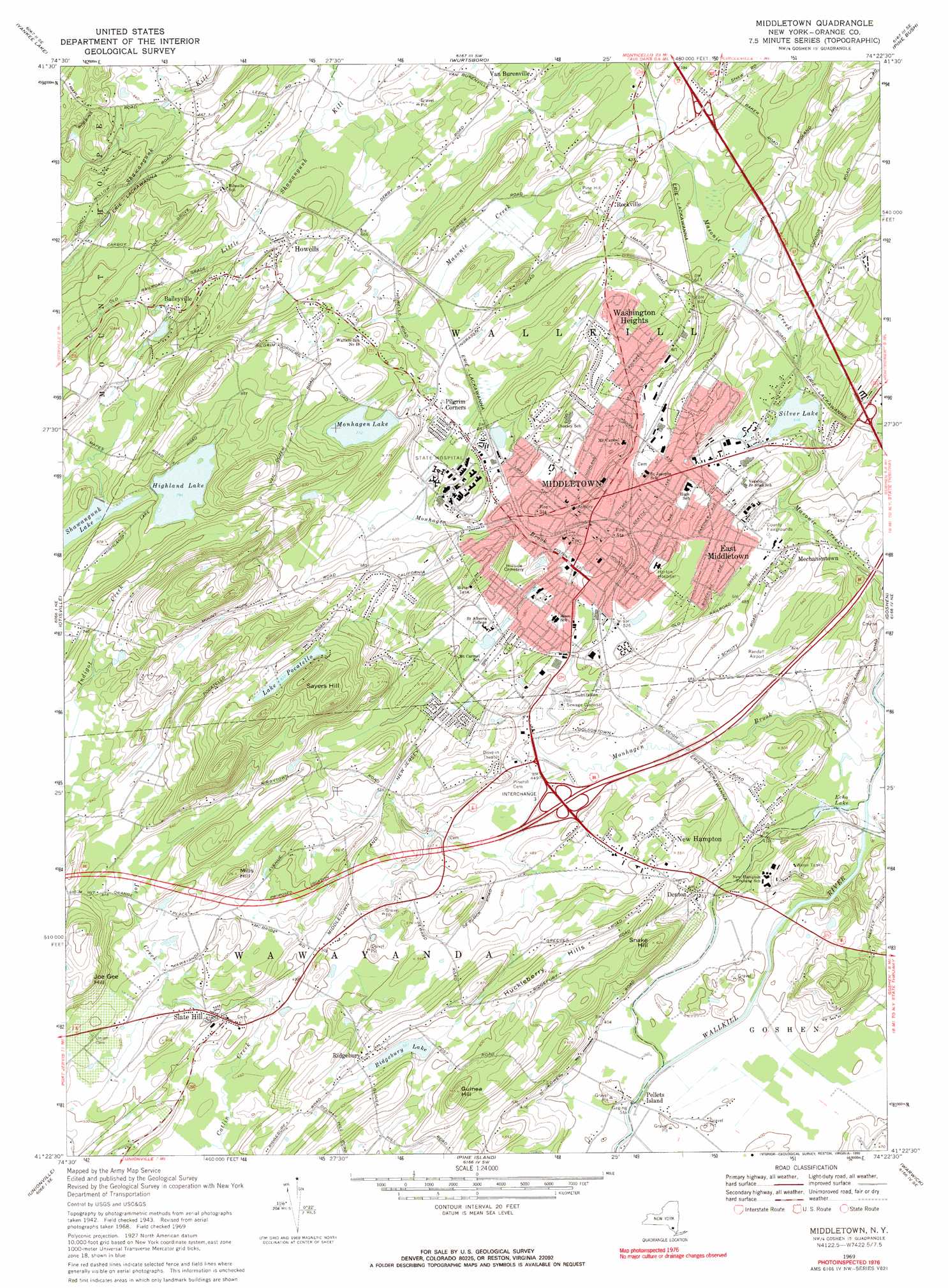
USGS Topo Quad 41074d4 - 1:24,000 scale
| Topo Map Name: | Middletown |
| USGS Topo Quad ID: | 41074d4 |
| Print Size: | ca. 21 1/4" wide x 27" high |
| Southeast Coordinates: | 41.375° N latitude / 74.375° W longitude |
| Map Center Coordinates: | 41.4375° N latitude / 74.4375° W longitude |
| U.S. State: | NY |
| Filename: | o41074d4.jpg |
| Download Map JPG Image: | Middletown topo map 1:24,000 scale |
| Map Type: | Topographic |
| Topo Series: | 7.5´ |
| Map Scale: | 1:24,000 |
| Source of Map Images: | United States Geological Survey (USGS) |
| Alternate Map Versions: |
Middletown NY 1942, updated 1959 Download PDF Buy paper map Middletown NY 1969, updated 1971 Download PDF Buy paper map Middletown NY 1969, updated 1990 Download PDF Buy paper map Middletown NY 2010 Download PDF Buy paper map Middletown NY 2013 Download PDF Buy paper map Middletown NY 2016 Download PDF Buy paper map |
1:24,000 Topo Quads surrounding Middletown
Monticello |
Woodridge |
Ellenville |
Napanoch |
Gardiner |
Hartwood |
Yankee Lake |
Wurtsboro |
Pine Bush |
Walden |
Port Jervis North |
Otisville |
Middletown |
Goshen |
Maybrook |
Port Jervis South |
Unionville |
Pine Island |
Warwick |
Monroe |
Branchville |
Hamburg |
Wawayanda |
Greenwood Lake |
Sloatsburg |
> Back to 41074a1 at 1:100,000 scale
> Back to 41074a1 at 1:250,000 scale
> Back to U.S. Topo Maps home
Middletown topo map: Gazetteer
Middletown: Airports
Randall Airport elevation 154m 505′Starhaven Airport (historical) elevation 221m 725′
Middletown: Lakes
Echo Lake elevation 114m 374′Lake Pocatello elevation 264m 866′
Monhagen Lake elevation 217m 711′
Ridgebury Lake elevation 168m 551′
Silver Lake elevation 158m 518′
Middletown: Parks
Academy Avenue Park elevation 153m 501′Amchir Park elevation 170m 557′
Clemson Park elevation 189m 620′
Fancer Davidge Park elevation 194m 636′
Fancher Davidge Park elevation 194m 636′
Maple Hill Park elevation 191m 626′
Shannen Park elevation 139m 456′
Summit Field elevation 194m 636′
Thrall Park elevation 182m 597′
Washington Heights Park elevation 196m 643′
Watts Memorial Park elevation 188m 616′
Middletown: Populated Places
Baileyville elevation 205m 672′Canterbury Knolls elevation 151m 495′
Deer Run elevation 176m 577′
Denton elevation 136m 446′
East Middletown elevation 158m 518′
Howells elevation 207m 679′
Keystone Park elevation 202m 662′
Mechanicstown elevation 162m 531′
Middletown elevation 170m 557′
New Hampton elevation 164m 538′
Pellets Island elevation 117m 383′
Pilgrim Corners elevation 195m 639′
Ridgebury elevation 179m 587′
Rockville elevation 196m 643′
Slate Hill elevation 152m 498′
Van Burenville elevation 201m 659′
Washington Heights elevation 203m 666′
Middletown: Post Offices
Middletown Post Office elevation 159m 521′Middletown: Ranges
Huckleberry Hills elevation 201m 659′Middletown: Reservoirs
Highland Lake elevation 241m 790′Shawangunk Lake elevation 234m 767′
Middletown: Streams
Joe Creek elevation 140m 459′Middletown: Summits
Guinea Hill elevation 234m 767′Joe Gee Hill elevation 238m 780′
Mills Hill elevation 221m 725′
Pellets Island Mountain elevation 128m 419′
Sayers Hill elevation 303m 994′
Snake Hill elevation 190m 623′
Middletown digital topo map on disk
Buy this Middletown topo map showing relief, roads, GPS coordinates and other geographical features, as a high-resolution digital map file on DVD:
New York, Vermont, Connecticut & Western Massachusetts
Buy digital topo maps: New York, Vermont, Connecticut & Western Massachusetts