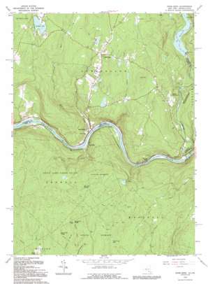
Pond Eddy Topo Map New York
To zoom in, hover over the map of Pond Eddy
USGS Topo Quad 41074d7 - 1:24,000 scale
| Topo Map Name: | Pond Eddy |
| USGS Topo Quad ID: | 41074d7 |
| Print Size: | ca. 21 1/4" wide x 27" high |
| Southeast Coordinates: | 41.375° N latitude / 74.75° W longitude |
| Map Center Coordinates: | 41.4375° N latitude / 74.8125° W longitude |
| U.S. States: | NY, PA |
| Filename: | o41074d7.jpg |
| Download Map JPG Image: | Pond Eddy topo map 1:24,000 scale |
| Map Type: | Topographic |
| Topo Series: | 7.5´ |
| Map Scale: | 1:24,000 |
| Source of Map Images: | United States Geological Survey (USGS) |
| Alternate Map Versions: |
Pond Eddy NY 1965, updated 1967 Download PDF Buy paper map Pond Eddy NY 1965, updated 1973 Download PDF Buy paper map Pond Eddy NY 1965, updated 1974 Download PDF Buy paper map Pond Eddy NY 1965, updated 1974 Download PDF Buy paper map Pond Eddy NY 1965, updated 1989 Download PDF Buy paper map Pond Eddy NY 1992, updated 1994 Download PDF Buy paper map Pond Eddy NY 1997, updated 1999 Download PDF Buy paper map Pond Eddy NY 2010 Download PDF Buy paper map Pond Eddy NY 2013 Download PDF Buy paper map Pond Eddy NY 2016 Download PDF Buy paper map |
1:24,000 Topo Quads surrounding Pond Eddy
> Back to 41074a1 at 1:100,000 scale
> Back to 41074a1 at 1:250,000 scale
> Back to U.S. Topo Maps home
Pond Eddy topo map: Gazetteer
Pond Eddy: Areas
Buckhorn Natural Area elevation 391m 1282′Pond Eddy: Bays
Wallowing Hole elevation 406m 1332′Pond Eddy: Dams
Stairway Hunt Club Dam elevation 335m 1099′Pond Eddy: Lakes
Lochada Lake elevation 377m 1236′Pond Eddy: Parks
State Game Lands Number 209 elevation 346m 1135′Pond Eddy: Populated Places
Glen Spey elevation 391m 1282′Knights Eddy elevation 203m 666′
Mongaup elevation 153m 501′
Pond Eddy elevation 170m 557′
Pond Eddy elevation 191m 626′
Rosas elevation 167m 547′
Upper Mongaup elevation 270m 885′
Pond Eddy: Reservoirs
Rio Reservoir elevation 249m 816′Stairway Lake elevation 335m 1099′
Pond Eddy: Ridges
Buckhorn Ridge elevation 448m 1469′Pine Knot Ridge elevation 451m 1479′
Pond Eddy: Streams
Bush Kill elevation 202m 662′Fish Cabin Creek elevation 146m 479′
Mill Brook elevation 152m 498′
Mongaup River elevation 140m 459′
Pond Eddy Creek elevation 153m 501′
Pond Eddy: Summits
Tink Hill elevation 426m 1397′Pond Eddy: Swamps
Bushkill Swamp elevation 388m 1272′Pond Eddy: Trails
Lost Cabin Trail elevation 409m 1341′Pond Eddy digital topo map on disk
Buy this Pond Eddy topo map showing relief, roads, GPS coordinates and other geographical features, as a high-resolution digital map file on DVD:
New York, Vermont, Connecticut & Western Massachusetts
Buy digital topo maps: New York, Vermont, Connecticut & Western Massachusetts


