Yankee Lake Topo Map New York
To zoom in, hover over the map of Yankee Lake
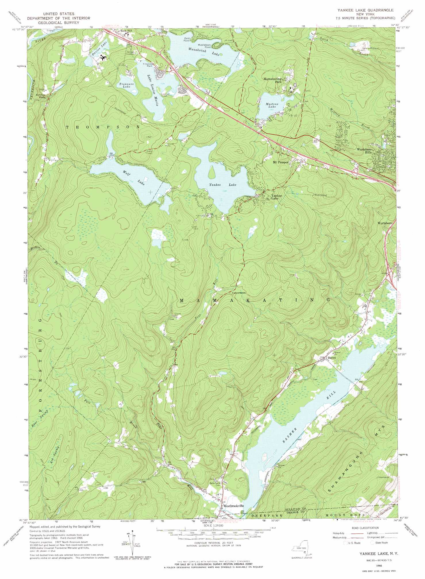
USGS Topo Quad 41074e5 - 1:24,000 scale
| Topo Map Name: | Yankee Lake |
| USGS Topo Quad ID: | 41074e5 |
| Print Size: | ca. 21 1/4" wide x 27" high |
| Southeast Coordinates: | 41.5° N latitude / 74.5° W longitude |
| Map Center Coordinates: | 41.5625° N latitude / 74.5625° W longitude |
| U.S. State: | NY |
| Filename: | o41074e5.jpg |
| Download Map JPG Image: | Yankee Lake topo map 1:24,000 scale |
| Map Type: | Topographic |
| Topo Series: | 7.5´ |
| Map Scale: | 1:24,000 |
| Source of Map Images: | United States Geological Survey (USGS) |
| Alternate Map Versions: |
Yankee Lake NY 1966, updated 1968 Download PDF Buy paper map Yankee Lake NY 1966, updated 1976 Download PDF Buy paper map Yankee Lake NY 1966, updated 1990 Download PDF Buy paper map Yankee Lake NY 2010 Download PDF Buy paper map Yankee Lake NY 2013 Download PDF Buy paper map Yankee Lake NY 2016 Download PDF Buy paper map |
1:24,000 Topo Quads surrounding Yankee Lake
Liberty West |
Liberty East |
Grahamsville |
Rondout Reservoir |
Kerhonkson |
White Lake |
Monticello |
Woodridge |
Ellenville |
Napanoch |
Highland Lake |
Hartwood |
Yankee Lake |
Wurtsboro |
Pine Bush |
Pond Eddy |
Port Jervis North |
Otisville |
Middletown |
Goshen |
Milford |
Port Jervis South |
Unionville |
Pine Island |
Warwick |
> Back to 41074e1 at 1:100,000 scale
> Back to 41074a1 at 1:250,000 scale
> Back to U.S. Topo Maps home
Yankee Lake topo map: Gazetteer
Yankee Lake: Capes
Gold Point elevation 464m 1522′Middletown Point elevation 463m 1519′
Yankee Lake: Falls
Katrina Falls elevation 356m 1167′Yankee Lake: Lakes
Davis Lake elevation 409m 1341′Mastens Lake elevation 477m 1564′
Treasure Lake elevation 468m 1535′
Wolf Lake elevation 459m 1505′
Yankee Lake elevation 438m 1437′
Yankee Lake: Populated Places
Culvertown elevation 393m 1289′Haven elevation 161m 528′
Mamakating Park elevation 496m 1627′
Mount Prosper elevation 462m 1515′
Wurtsboro Hills elevation 346m 1135′
Yankee Lake elevation 459m 1505′
Yankee Lake: Reservoirs
Lake Louise Marie elevation 466m 1528′Wanaksink Lake elevation 459m 1505′
Yankee Lake: Streams
Fall Brook elevation 207m 679′Yankee Lake: Swamps
Ash Swamp elevation 423m 1387′Bear Swamp elevation 461m 1512′
Yankee Lake digital topo map on disk
Buy this Yankee Lake topo map showing relief, roads, GPS coordinates and other geographical features, as a high-resolution digital map file on DVD:
New York, Vermont, Connecticut & Western Massachusetts
Buy digital topo maps: New York, Vermont, Connecticut & Western Massachusetts