Willowemoc Topo Map New York
To zoom in, hover over the map of Willowemoc
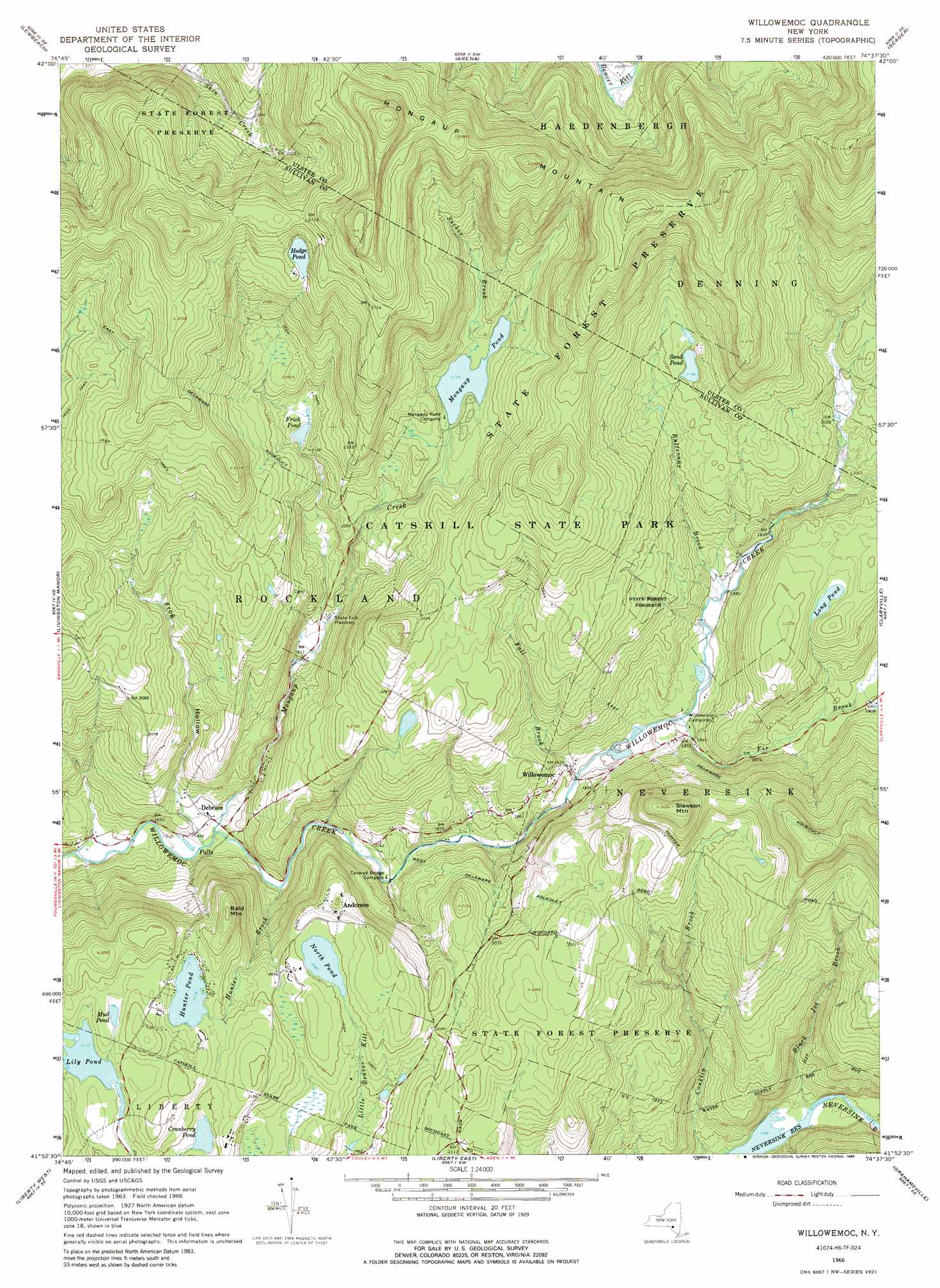
USGS Topo Quad 41074h6 - 1:24,000 scale
| Topo Map Name: | Willowemoc |
| USGS Topo Quad ID: | 41074h6 |
| Print Size: | ca. 21 1/4" wide x 27" high |
| Southeast Coordinates: | 41.875° N latitude / 74.625° W longitude |
| Map Center Coordinates: | 41.9375° N latitude / 74.6875° W longitude |
| U.S. State: | NY |
| Filename: | o41074h6.jpg |
| Download Map JPG Image: | Willowemoc topo map 1:24,000 scale |
| Map Type: | Topographic |
| Topo Series: | 7.5´ |
| Map Scale: | 1:24,000 |
| Source of Map Images: | United States Geological Survey (USGS) |
| Alternate Map Versions: |
Willowemoc NY 1966, updated 1968 Download PDF Buy paper map Willowemoc NY 1966, updated 1973 Download PDF Buy paper map Willowemoc NY 1966, updated 1989 Download PDF Buy paper map Willowemoc NY 1997, updated 2000 Download PDF Buy paper map Willowemoc NY 2010 Download PDF Buy paper map Willowemoc NY 2013 Download PDF Buy paper map Willowemoc NY 2016 Download PDF Buy paper map |
1:24,000 Topo Quads surrounding Willowemoc
Hamden |
Andes |
Margaretville |
Fleischmanns |
West Kill |
Downsville |
Lewbeach |
Arena |
Seager |
Shandaken |
Roscoe |
Livingston Manor |
Willowemoc |
Claryville |
Peekamoose Mountain |
Jeffersonville |
Liberty West |
Liberty East |
Grahamsville |
Rondout Reservoir |
Lake Huntington |
White Lake |
Monticello |
Woodridge |
Ellenville |
> Back to 41074e1 at 1:100,000 scale
> Back to 41074a1 at 1:250,000 scale
> Back to U.S. Topo Maps home
Willowemoc topo map: Gazetteer
Willowemoc: Canals
West Delaware Aqueduct elevation 598m 1961′Willowemoc: Lakes
Cranberry Pond elevation 634m 2080′Frick Pond elevation 645m 2116′
Hodge Pond elevation 790m 2591′
Hunter Pond elevation 645m 2116′
Lily Pond elevation 644m 2112′
Long Pond elevation 648m 2125′
Mongaup Pond elevation 652m 2139′
Mud Pond elevation 657m 2155′
North Pond elevation 636m 2086′
Sand Pond elevation 669m 2194′
Willowemoc: Populated Places
Anderson elevation 659m 2162′Debruce elevation 508m 1666′
Willowemoc elevation 554m 1817′
Willowemoc: Streams
Black Joe Brook elevation 439m 1440′Butternut Brook elevation 569m 1866′
Fall Brook elevation 542m 1778′
Fir Brook elevation 554m 1817′
Hunter Brook elevation 506m 1660′
Mongaup Creek elevation 499m 1637′
Sucker Brook elevation 652m 2139′
Willowemoc: Summits
Bald Mountain elevation 703m 2306′Mongaup Mountain elevation 842m 2762′
Slawson Mountain elevation 760m 2493′
Willowemoc: Valleys
Frog Hollow elevation 512m 1679′Willowemoc digital topo map on disk
Buy this Willowemoc topo map showing relief, roads, GPS coordinates and other geographical features, as a high-resolution digital map file on DVD:
New York, Vermont, Connecticut & Western Massachusetts
Buy digital topo maps: New York, Vermont, Connecticut & Western Massachusetts