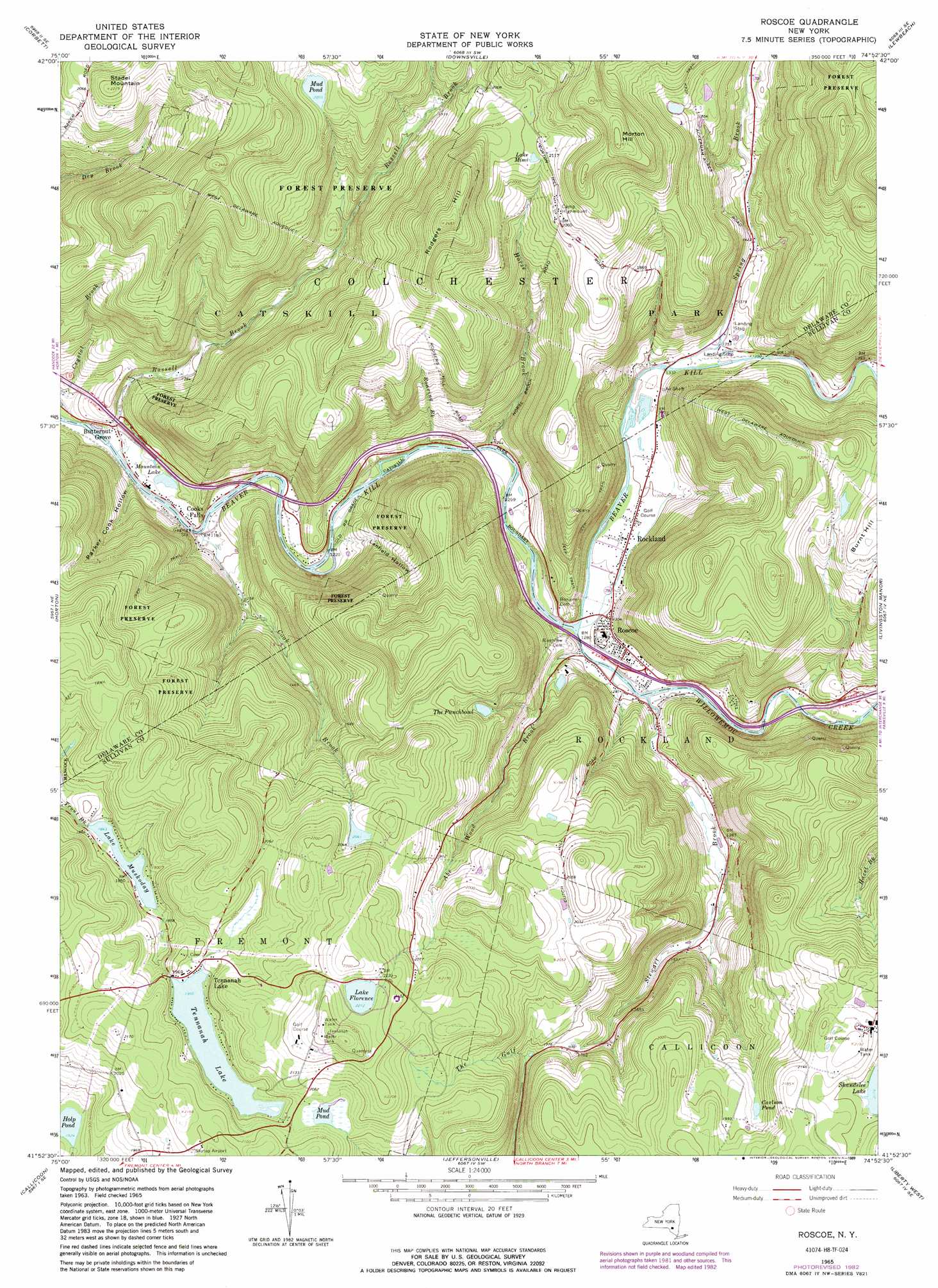
Roscoe Topo Map New York
To zoom in, hover over the map of Roscoe
USGS Topo Quad 41074h8 - 1:24,000 scale
| Topo Map Name: | Roscoe |
| USGS Topo Quad ID: | 41074h8 |
| Print Size: | ca. 21 1/4" wide x 27" high |
| Southeast Coordinates: | 41.875° N latitude / 74.875° W longitude |
| Map Center Coordinates: | 41.9375° N latitude / 74.9375° W longitude |
| U.S. State: | NY |
| Filename: | o41074h8.jpg |
| Download Map JPG Image: | Roscoe topo map 1:24,000 scale |
| Map Type: | Topographic |
| Topo Series: | 7.5´ |
| Map Scale: | 1:24,000 |
| Source of Map Images: | United States Geological Survey (USGS) |
| Alternate Map Versions: |
Roscoe NY 1965, updated 1967 Download PDF Buy paper map Roscoe NY 1965, updated 1983 Download PDF Buy paper map Roscoe NY 1965, updated 1989 Download PDF Buy paper map Roscoe NY 2010 Download PDF Buy paper map Roscoe NY 2013 Download PDF Buy paper map Roscoe NY 2016 Download PDF Buy paper map |
1:24,000 Topo Quads surrounding Roscoe
Walton West |
Walton East |
Hamden |
Andes |
Margaretville |
Readburn |
Corbett |
Downsville |
Lewbeach |
Arena |
Fishs Eddy |
Horton |
Roscoe |
Livingston Manor |
Willowemoc |
Long Eddy |
Callicoon |
Jeffersonville |
Liberty West |
Liberty East |
Galilee |
Damascus |
Lake Huntington |
White Lake |
Monticello |
> Back to 41074e1 at 1:100,000 scale
> Back to 41074a1 at 1:250,000 scale
> Back to U.S. Topo Maps home
Roscoe topo map: Gazetteer
Roscoe: Airports
James Carl Memorial Heliport elevation 641m 2103′Skytop Airport elevation 635m 2083′
Roscoe: Bridges
Bendo Bridge elevation 394m 1292′Roscoe: Lakes
Carlson Pond elevation 595m 1952′Holp Pond elevation 556m 1824′
Lake Florence elevation 674m 2211′
Lake Mimi elevation 636m 2086′
Lake Muskoday elevation 562m 1843′
Mountain Lake elevation 360m 1181′
Mud Pond elevation 613m 2011′
Mud Pond elevation 625m 2050′
Tennanah Lake elevation 596m 1955′
The Punchbowl elevation 539m 1768′
Roscoe: Populated Places
Butternut Grove elevation 355m 1164′Cooks Falls elevation 354m 1161′
Rockland elevation 394m 1292′
Roscoe elevation 395m 1295′
Tennanah Lake elevation 608m 1994′
Roscoe: Streams
Abe Wood Brook elevation 384m 1259′Cook Brook elevation 350m 1148′
Horse Brook elevation 371m 1217′
Roaring Brook elevation 372m 1220′
Russell Brook elevation 344m 1128′
Spring Brook elevation 403m 1322′
Stewart Brook elevation 384m 1259′
Willowemoc Creek elevation 384m 1259′
Roscoe: Summits
Morton Hill elevation 765m 2509′Rodgers Hill elevation 755m 2477′
Stadel Mountain elevation 678m 2224′
Roscoe: Valleys
Cooks Hollow elevation 352m 1154′Lanfield Hollow elevation 380m 1246′
Parker Cook Hollow elevation 364m 1194′
Roscoe digital topo map on disk
Buy this Roscoe topo map showing relief, roads, GPS coordinates and other geographical features, as a high-resolution digital map file on DVD:
New York, Vermont, Connecticut & Western Massachusetts
Buy digital topo maps: New York, Vermont, Connecticut & Western Massachusetts