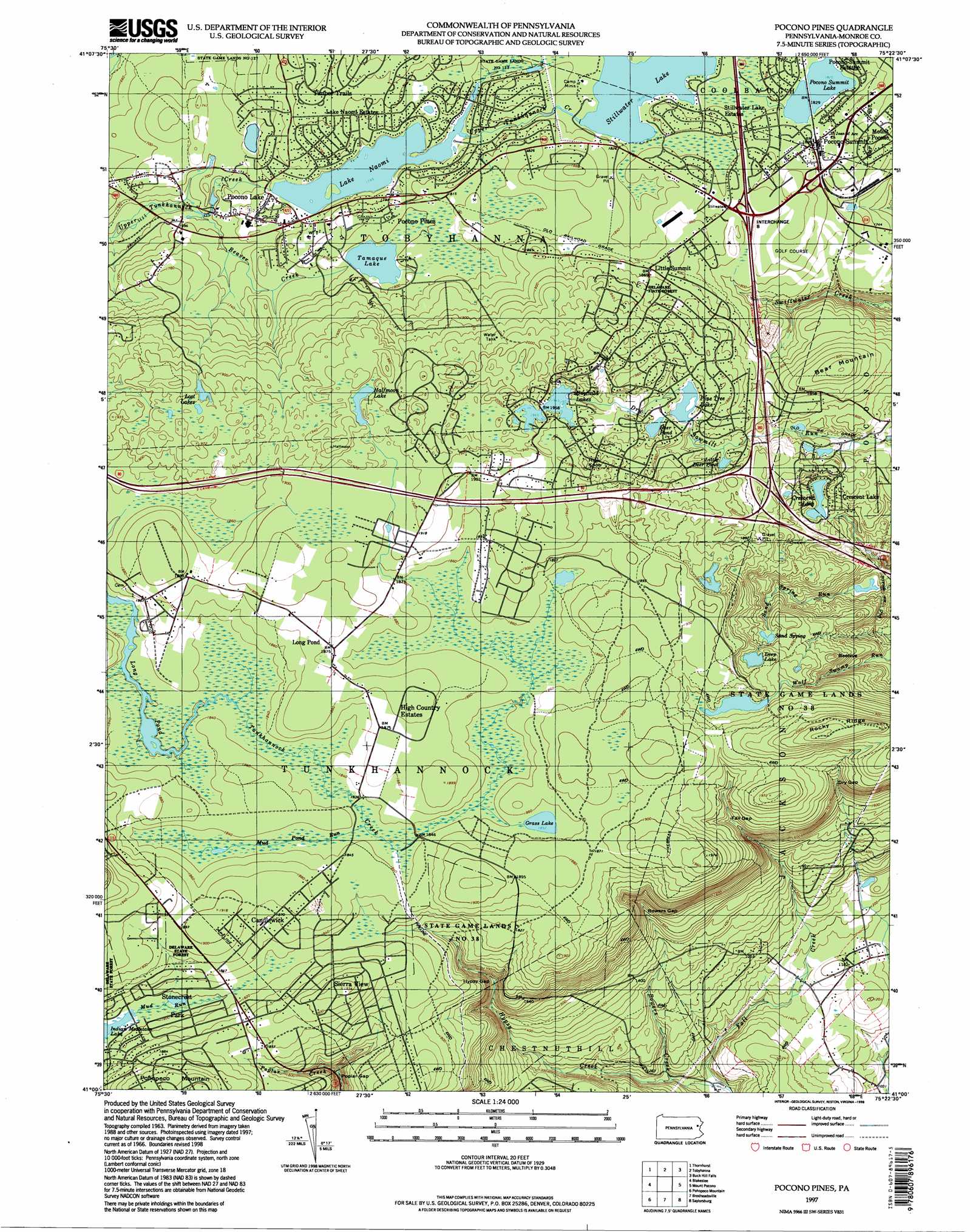
Pocono Pines Topo Map Pennsylvania
To zoom in, hover over the map of Pocono Pines
USGS Topo Quad 41075a4 - 1:24,000 scale
| Topo Map Name: | Pocono Pines |
| USGS Topo Quad ID: | 41075a4 |
| Print Size: | ca. 21 1/4" wide x 27" high |
| Southeast Coordinates: | 41° N latitude / 75.375° W longitude |
| Map Center Coordinates: | 41.0625° N latitude / 75.4375° W longitude |
| U.S. State: | PA |
| Filename: | o41075a4.jpg |
| Download Map JPG Image: | Pocono Pines topo map 1:24,000 scale |
| Map Type: | Topographic |
| Topo Series: | 7.5´ |
| Map Scale: | 1:24,000 |
| Source of Map Images: | United States Geological Survey (USGS) |
| Alternate Map Versions: |
Pocono Pines PA 1966, updated 1967 Download PDF Buy paper map Pocono Pines PA 1966, updated 1974 Download PDF Buy paper map Pocono Pines PA 1966, updated 1977 Download PDF Buy paper map Pocono Pines PA 1966, updated 1984 Download PDF Buy paper map Pocono Pines PA 1966, updated 1984 Download PDF Buy paper map Pocono Pines PA 1966, updated 1992 Download PDF Buy paper map Pocono Pines PA 1976, updated 1978 Download PDF Buy paper map Pocono Pines PA 1997, updated 1998 Download PDF Buy paper map Pocono Pines PA 2010 Download PDF Buy paper map Pocono Pines PA 2013 Download PDF Buy paper map Pocono Pines PA 2016 Download PDF Buy paper map |
1:24,000 Topo Quads surrounding Pocono Pines
Avoca |
Moscow |
Sterling |
Newfoundland |
Promised Land |
Pleasant View Summit |
Thornhurst |
Tobyhanna |
Buck Hill Falls |
Skytop |
Hickory Run |
Blakeslee |
Pocono Pines |
Mount Pocono |
East Stroudsburg |
Christmans |
Pohopoco Mountain |
Brodheadsville |
Saylorsburg |
Stroudsburg |
Lehighton |
Palmerton |
Kunkletown |
Wind Gap |
Bangor |
> Back to 41075a1 at 1:100,000 scale
> Back to 41074a1 at 1:250,000 scale
> Back to U.S. Topo Maps home
Pocono Pines topo map: Gazetteer
Pocono Pines: Crossings
Interchange 8 elevation 560m 1837′Pocono Pines: Dams
Crescent Lake Dam elevation 538m 1765′Lake Naomi Dam elevation 531m 1742′
Lake Naomi Dam elevation 533m 1748′
Lutherland Dam elevation 552m 1811′
Pinetree Lake Dam elevation 562m 1843′
Pocono Pine Dam elevation 510m 1673′
Stillwater Lake Dam elevation 552m 1811′
Summit Lake Dam elevation 558m 1830′
Youngs Pond Dam elevation 592m 1942′
Pocono Pines: Gaps
Bowers Gap elevation 456m 1496′Dry Gap elevation 520m 1706′
Fall Gap elevation 528m 1732′
Hypsy Gap elevation 482m 1581′
Poplar Gap elevation 485m 1591′
Pocono Pines: Lakes
Deep Lake elevation 560m 1837′Deer Pond elevation 574m 1883′
Grass Lake elevation 562m 1843′
Halfmoon Lake elevation 588m 1929′
Little Deer Pond elevation 554m 1817′
Lost Lakes elevation 584m 1916′
Pocono Summit Lake elevation 556m 1824′
Ramot Lakes elevation 592m 1942′
Pocono Pines: Parks
State Game Lands Number 38 elevation 586m 1922′Pocono Pines: Populated Places
Crescent Lake elevation 542m 1778′Emerald Lakes elevation 613m 2011′
Indian Mountain Lake elevation 549m 1801′
Lake Naomi Estates elevation 537m 1761′
Little Summit elevation 571m 1873′
Long Pond elevation 570m 1870′
Pocono Lake elevation 533m 1748′
Pocono Pines elevation 550m 1804′
Pocono Summit elevation 554m 1817′
Pocono Summit Estates elevation 559m 1833′
Stillwater Lake Estates elevation 555m 1820′
Sun Valley elevation 571m 1873′
Pocono Pines: Post Offices
Pocono Post Office (historical) elevation 558m 1830′Pocono Pines: Reservoirs
Crescent Lake elevation 526m 1725′Lake Naomi elevation 533m 1748′
Pine Tree Lake elevation 562m 1843′
Stillwater Lake elevation 552m 1811′
Summit Lake elevation 558m 1830′
Tamaque Lake elevation 545m 1788′
Pocono Pines: Ridges
Rocky Ridge elevation 628m 2060′Pocono Pines: Springs
Sand Spring elevation 539m 1768′Pocono Pines: Streams
Beaver Creek elevation 507m 1663′Bowers Creek elevation 334m 1095′
Mud Pond Run elevation 560m 1837′
Pocono Pines: Summits
Bear Mountain elevation 591m 1938′Beehive elevation 561m 1840′
High Knob elevation 608m 1994′
Pohopoco Mountain elevation 612m 2007′
Pocono Pines digital topo map on disk
Buy this Pocono Pines topo map showing relief, roads, GPS coordinates and other geographical features, as a high-resolution digital map file on DVD:
New York, Vermont, Connecticut & Western Massachusetts
Buy digital topo maps: New York, Vermont, Connecticut & Western Massachusetts