Promised Land Topo Map Pennsylvania
To zoom in, hover over the map of Promised Land
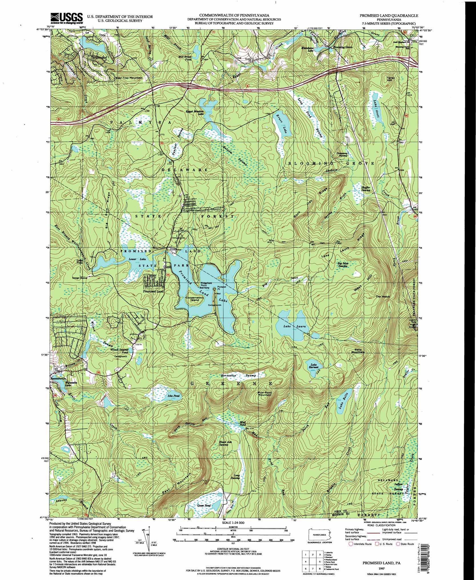
USGS Topo Quad 41075c2 - 1:24,000 scale
| Topo Map Name: | Promised Land |
| USGS Topo Quad ID: | 41075c2 |
| Print Size: | ca. 21 1/4" wide x 27" high |
| Southeast Coordinates: | 41.25° N latitude / 75.125° W longitude |
| Map Center Coordinates: | 41.3125° N latitude / 75.1875° W longitude |
| U.S. State: | PA |
| Filename: | o41075c2.jpg |
| Download Map JPG Image: | Promised Land topo map 1:24,000 scale |
| Map Type: | Topographic |
| Topo Series: | 7.5´ |
| Map Scale: | 1:24,000 |
| Source of Map Images: | United States Geological Survey (USGS) |
| Alternate Map Versions: |
Promised Land PA 1966, updated 1968 Download PDF Buy paper map Promised Land PA 1966, updated 1974 Download PDF Buy paper map Promised Land PA 1966, updated 1988 Download PDF Buy paper map Promised Land PA 1976, updated 1978 Download PDF Buy paper map Promised Land PA 1994, updated 1995 Download PDF Buy paper map Promised Land PA 1997, updated 1998 Download PDF Buy paper map Promised Land PA 2010 Download PDF Buy paper map Promised Land PA 2013 Download PDF Buy paper map Promised Land PA 2016 Download PDF Buy paper map |
1:24,000 Topo Quads surrounding Promised Land
Waymart |
Honesdale |
White Mills |
Narrowsburg |
Eldred |
Lake Ariel |
Lakeville |
Hawley |
Rowland |
Shohola |
Sterling |
Newfoundland |
Promised Land |
Pecks Pond |
Edgemere |
Tobyhanna |
Buck Hill Falls |
Skytop |
Twelvemile Pond |
Lake Maskenozha |
Pocono Pines |
Mount Pocono |
East Stroudsburg |
Bushkill |
Flatbrookville |
> Back to 41075a1 at 1:100,000 scale
> Back to 41074a1 at 1:250,000 scale
> Back to U.S. Topo Maps home
Promised Land topo map: Gazetteer
Promised Land: Airports
Tanglewood Golf Course Airport elevation 475m 1558′Promised Land: Areas
Bruce Lake Natural Area elevation 524m 1719′Promised Land: Capes
Pickerel Point elevation 525m 1722′Ridgefield Point elevation 528m 1732′
Promised Land: Dams
Egypt Meadow Dam elevation 523m 1715′Gumble Brothers Dam elevation 484m 1587′
Kintz Creek Dam elevation 488m 1601′
Lake Laura Dam elevation 567m 1860′
Lake Laura Dam elevation 561m 1840′
Lake Wynooska Dam elevation 480m 1574′
Lower Lake Dam elevation 528m 1732′
Lumber Company Dam elevation 436m 1430′
Number Three Dam elevation 535m 1755′
Promised Land Dam elevation 528m 1732′
Wilson Creek Dam elevation 505m 1656′
Wyler Dam elevation 444m 1456′
Promised Land: Falls
Little Falls elevation 512m 1679′Promised Land: Gaps
The Notch elevation 512m 1679′Promised Land: Islands
Conservation Island elevation 536m 1758′Promised Land: Lakes
Bruce Lake elevation 527m 1729′Goose Pond elevation 445m 1459′
Kleinhans Lake elevation 445m 1459′
Lake Belle elevation 495m 1624′
Lake Earnest elevation 570m 1870′
Lake Scott elevation 469m 1538′
Wilsons Swamp Pond elevation 533m 1748′
Promised Land: Parks
Promised Land State Park elevation 532m 1745′Promised Land: Populated Places
Blooming Grove elevation 438m 1437′Promised Land elevation 540m 1771′
Roemersville elevation 499m 1637′
Sky View Lake elevation 540m 1771′
Tanglewood Estate elevation 418m 1371′
Promised Land: Ranges
Pocono Mountains elevation 537m 1761′Promised Land: Reservoirs
Egypt Meadow Lake elevation 521m 1709′Icks Pond elevation 532m 1745′
Kintz Creek Lake elevation 488m 1601′
Lake Laura elevation 562m 1843′
Lower Lake elevation 520m 1706′
Mill Brook Pond elevation 484m 1587′
Mud Pond elevation 430m 1410′
Promised Land Lake elevation 530m 1738′
Wilson Creek Lake elevation 505m 1656′
Wynooska Lake elevation 480m 1574′
Promised Land: Ridges
Big Dam Ridge elevation 555m 1820′Lake Laura Ridge elevation 583m 1912′
Rock Oak Ridge elevation 528m 1732′
Promised Land: Streams
Big Inlet elevation 527m 1729′Dark Hollow Run elevation 430m 1410′
Egypt Creek elevation 521m 1709′
Fairview Outlet elevation 446m 1463′
Kintz Creek elevation 479m 1571′
Mozette Creek elevation 485m 1591′
Notch Brook elevation 434m 1423′
Perch Run elevation 396m 1299′
Spring Brook elevation 462m 1515′
Wilson Creek elevation 481m 1578′
Promised Land: Summits
Bear Trap Mountain elevation 529m 1735′Belle Mountain elevation 576m 1889′
East Mountain elevation 579m 1899′
Mud Pond Mountain elevation 582m 1909′
Tarey Hill elevation 498m 1633′
West Hill elevation 605m 1984′
Promised Land: Swamps
Balsam Swamp elevation 522m 1712′Big Inlet Swamp elevation 570m 1870′
Black Ash Swamp elevation 455m 1492′
Company Swamp elevation 462m 1515′
Horseshoe Swamp elevation 521m 1709′
Indian Swamp elevation 412m 1351′
Long Pond Swamp elevation 497m 1630′
Long Swamp elevation 437m 1433′
Panther Swamp elevation 534m 1751′
Shaffer Swamp elevation 462m 1515′
Wilson Swamp elevation 523m 1715′
Promised Land: Trails
Boundary Trail elevation 528m 1732′Brown Trail elevation 547m 1794′
Bruce Lake Trail elevation 548m 1797′
Burley Inlet Trail elevation 552m 1811′
East Branch Bruce Lake Trail elevation 538m 1765′
Lake Laura Trail elevation 541m 1774′
Rock Oak Trail elevation 573m 1879′
Rock Oak Trail elevation 565m 1853′
Snow Shanty Trail elevation 534m 1751′
Telephone Trail elevation 568m 1863′
West Branch Bruce Lake Trail elevation 529m 1735′
Whittaker Trail elevation 559m 1833′
Promised Land digital topo map on disk
Buy this Promised Land topo map showing relief, roads, GPS coordinates and other geographical features, as a high-resolution digital map file on DVD:
New York, Vermont, Connecticut & Western Massachusetts
Buy digital topo maps: New York, Vermont, Connecticut & Western Massachusetts