Pittston Topo Map Pennsylvania
To zoom in, hover over the map of Pittston
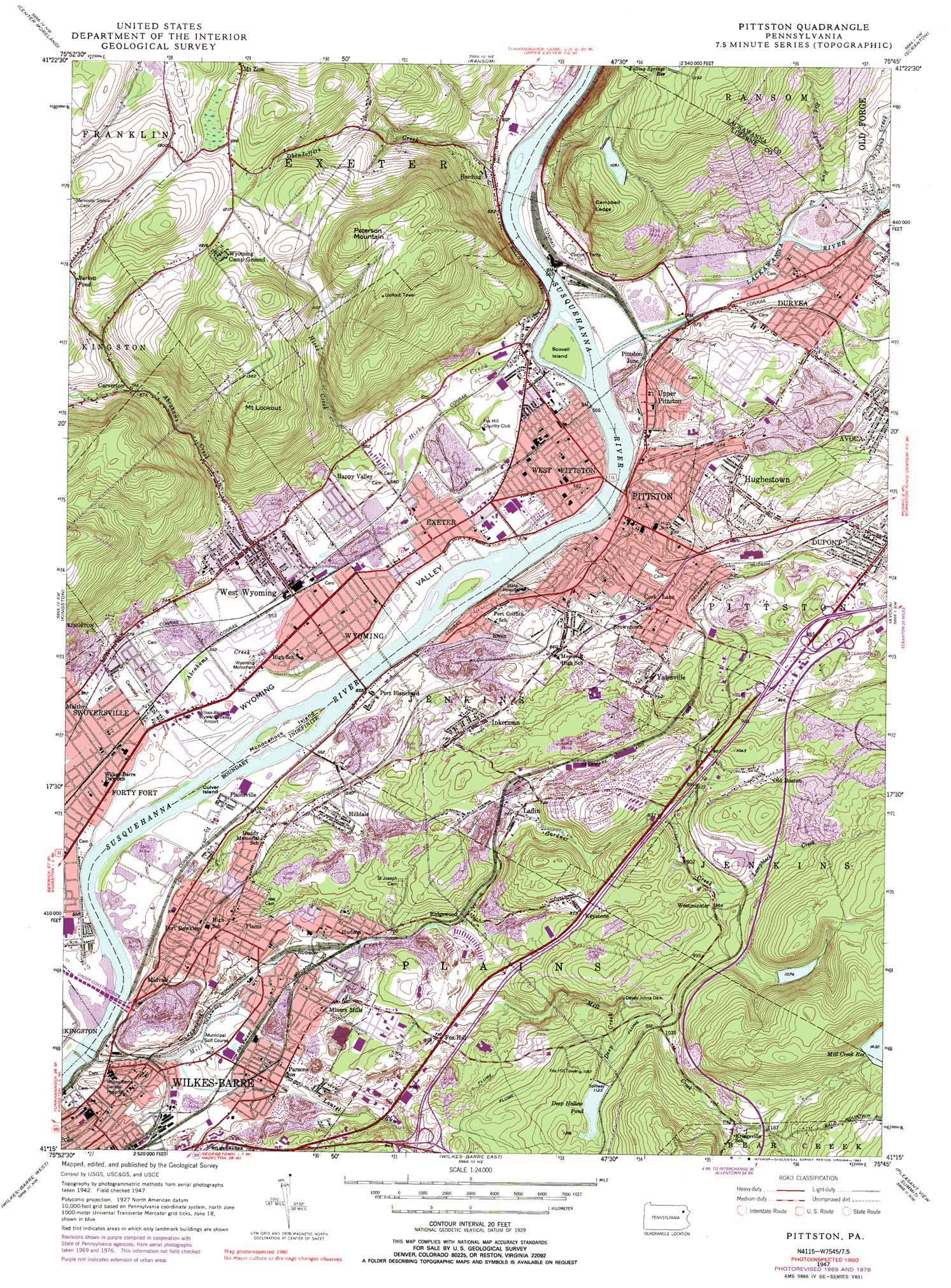
USGS Topo Quad 41075c7 - 1:24,000 scale
| Topo Map Name: | Pittston |
| USGS Topo Quad ID: | 41075c7 |
| Print Size: | ca. 21 1/4" wide x 27" high |
| Southeast Coordinates: | 41.25° N latitude / 75.75° W longitude |
| Map Center Coordinates: | 41.3125° N latitude / 75.8125° W longitude |
| U.S. State: | PA |
| Filename: | o41075c7.jpg |
| Download Map JPG Image: | Pittston topo map 1:24,000 scale |
| Map Type: | Topographic |
| Topo Series: | 7.5´ |
| Map Scale: | 1:24,000 |
| Source of Map Images: | United States Geological Survey (USGS) |
| Alternate Map Versions: |
Pittston PA 1947, updated 1961 Download PDF Buy paper map Pittston PA 1947, updated 1970 Download PDF Buy paper map Pittston PA 1947, updated 1978 Download PDF Buy paper map Pittston PA 1947, updated 1983 Download PDF Buy paper map Pittston PA 1949 Download PDF Buy paper map Pittston PA 1949 Download PDF Buy paper map Pittston PA 1976, updated 1979 Download PDF Buy paper map Pittston PA 1994, updated 1995 Download PDF Buy paper map Pittston PA 1999, updated 2002 Download PDF Buy paper map Pittston PA 2010 Download PDF Buy paper map Pittston PA 2013 Download PDF Buy paper map Pittston PA 2016 Download PDF Buy paper map |
1:24,000 Topo Quads surrounding Pittston
Meshoppen |
Tunkhannock |
Factoryville |
Dalton |
Carbondale |
Noxen |
Center Moreland |
Ransom |
Scranton |
Olyphant |
Harveys Lake |
Kingston |
Pittston |
Avoca |
Moscow |
Nanticoke |
Wilkes-Barre West |
Wilkes-Barre East |
Pleasant View Summit |
Thornhurst |
Sybertsville |
Freeland |
White Haven |
Hickory Run |
Blakeslee |
> Back to 41075a1 at 1:100,000 scale
> Back to 41074a1 at 1:250,000 scale
> Back to U.S. Topo Maps home
Pittston topo map: Gazetteer
Pittston: Airports
Wilkes-Barre Wyoming Valley Airport elevation 165m 541′Pittston: Benches
Campbell Ledge elevation 390m 1279′Pittston: Crossings
Pennsylvania Turnpike Interchange 37 elevation 275m 902′Pittston: Dams
Campbells Ledge Dam elevation 327m 1072′Deep Hollow Dam elevation 333m 1092′
Gardner Creek Dam elevation 340m 1115′
Mill Creek Intake Dam elevation 300m 984′
Pittston: Islands
Culver Island elevation 159m 521′Monocanock Island elevation 164m 538′
Scovell Island elevation 164m 538′
Wintermoot Island elevation 164m 538′
Wintermoot Island elevation 164m 538′
Pittston: Mines
Barnum Shaft Number 1 (historical) elevation 202m 662′Barnum Shaft Number 2 (historical) elevation 220m 721′
Boston Colliery (historical) elevation 303m 994′
Butler Shaft (historical) elevation 225m 738′
Clear Spring Shaft (historical) elevation 174m 570′
Eagle Shaft (historical) elevation 178m 583′
Exeter Shaft (historical) elevation 173m 567′
Heidelberg Shaft (historical) elevation 224m 734′
Hoyt Shaft (historical) elevation 179m 587′
Jumper Drift (historical) elevation 312m 1023′
Keystone Colliery (historical) elevation 266m 872′
Knight Shaft (historical) elevation 176m 577′
Maxwell Drift (historical) elevation 234m 767′
Mosier Shaft (historical) elevation 207m 679′
Niagara Shaft (historical) elevation 177m 580′
Phoenix Shaft (historical) elevation 172m 564′
Ravine Shaft (historical) elevation 177m 580′
Schooley Breaker (historical) elevation 171m 561′
Tompkins Shaft (historical) elevation 181m 593′
Twin Shaft (historical) elevation 174m 570′
Youngs Shaft (historical) elevation 253m 830′
Pittston: Parks
Wyoming Monument elevation 171m 561′Pittston: Populated Places
Browntown elevation 215m 705′Carverton elevation 264m 866′
Cork Lane elevation 210m 688′
Dickville elevation 172m 564′
Ewen elevation 194m 636′
Exeter elevation 172m 564′
Fox Hill elevation 219m 718′
Happy Valley elevation 181m 593′
Harding elevation 177m 580′
Hilldale elevation 182m 597′
Hudson elevation 191m 626′
Hughestown elevation 236m 774′
Inkerman elevation 241m 790′
Keystone elevation 268m 879′
Laflin elevation 222m 728′
Midvale elevation 181m 593′
Miners Mills elevation 205m 672′
Old Boston elevation 299m 980′
Parsons elevation 184m 603′
Pittston elevation 179m 587′
Pittston Junction elevation 175m 574′
Plains elevation 200m 656′
Plainsville elevation 166m 544′
Port Blanchard elevation 165m 541′
Port Bowkley elevation 175m 574′
Port Griffith elevation 196m 643′
Ridgewood elevation 210m 688′
Sebastopol elevation 203m 666′
Swoyersville elevation 169m 554′
Upper Pittston elevation 175m 574′
West Pittston elevation 166m 544′
West Wyoming elevation 181m 593′
Westminster elevation 292m 958′
Wyoming elevation 172m 564′
Yatesville elevation 230m 754′
Pittston: Reservoirs
Burkett Pond elevation 330m 1082′Campbells Ledge Reservoir elevation 327m 1072′
Deep Hollow Pond elevation 336m 1102′
Gardner Creek Reservoir elevation 340m 1115′
Mill Creek Reservoir elevation 423m 1387′
Yatesville Pond (historical) elevation 225m 738′
Pittston: Streams
Abrahams Creek elevation 159m 521′Deep Creek elevation 307m 1007′
Gardner Creek elevation 195m 639′
Hicks Creek elevation 162m 531′
Lackawanna River elevation 159m 521′
Lampblack Creek elevation 285m 935′
Laurel Run elevation 167m 547′
Mill Creek elevation 159m 521′
Obendoffers Creek elevation 159m 521′
Paddens Creek (historical) elevation 201m 659′
Paddens Creek (historical) elevation 209m 685′
Red Spring Run elevation 170m 557′
Saint Johns Creek elevation 176m 577′
Tompkins Creek (historical) elevation 272m 892′
Pittston: Summits
Mount Lookout elevation 449m 1473′Peterson Mountain elevation 481m 1578′
Pittston: Tunnels
Bowkley and Morgans Tunnel (historical) elevation 178m 583′Columbia Tunnel (historical) elevation 185m 606′
Grand Tunnel (historical) elevation 197m 646′
Old Rock Hill Tunnel (historical) elevation 186m 610′
Slocums Tunnel (historical) elevation 180m 590′
Yatesville Lower Tunnel (historical) elevation 243m 797′
Yatesville Upper Tunnel (historical) elevation 243m 797′
Pittston digital topo map on disk
Buy this Pittston topo map showing relief, roads, GPS coordinates and other geographical features, as a high-resolution digital map file on DVD:
New York, Vermont, Connecticut & Western Massachusetts
Buy digital topo maps: New York, Vermont, Connecticut & Western Massachusetts