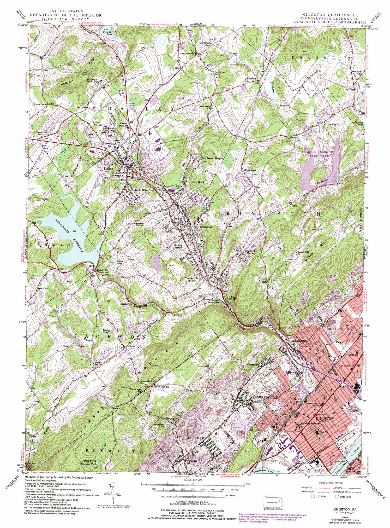
Kingston Topo Map Pennsylvania
To zoom in, hover over the map of Kingston
USGS Topo Quad 41075c8 - 1:24,000 scale
| Topo Map Name: | Kingston |
| USGS Topo Quad ID: | 41075c8 |
| Print Size: | ca. 21 1/4" wide x 27" high |
| Southeast Coordinates: | 41.25° N latitude / 75.875° W longitude |
| Map Center Coordinates: | 41.3125° N latitude / 75.9375° W longitude |
| U.S. State: | PA |
| Filename: | o41075c8.jpg |
| Download Map JPG Image: | Kingston topo map 1:24,000 scale |
| Map Type: | Topographic |
| Topo Series: | 7.5´ |
| Map Scale: | 1:24,000 |
| Source of Map Images: | United States Geological Survey (USGS) |
| Alternate Map Versions: |
Kingston PA 1946, updated 1959 Download PDF Buy paper map Kingston PA 1946, updated 1966 Download PDF Buy paper map Kingston PA 1946, updated 1969 Download PDF Buy paper map Kingston PA 1946, updated 1977 Download PDF Buy paper map Kingston PA 1946, updated 1984 Download PDF Buy paper map Kingston PA 1949, updated 1949 Download PDF Buy paper map Kingston PA 1976, updated 1979 Download PDF Buy paper map Kingston PA 2010 Download PDF Buy paper map Kingston PA 2013 Download PDF Buy paper map Kingston PA 2016 Download PDF Buy paper map |
1:24,000 Topo Quads surrounding Kingston
Jenningsville |
Meshoppen |
Tunkhannock |
Factoryville |
Dalton |
Dutch Mountain |
Noxen |
Center Moreland |
Ransom |
Scranton |
Sweet Valley |
Harveys Lake |
Kingston |
Pittston |
Avoca |
Shickshinny |
Nanticoke |
Wilkes-Barre West |
Wilkes-Barre East |
Pleasant View Summit |
Berwick |
Sybertsville |
Freeland |
White Haven |
Hickory Run |
> Back to 41075a1 at 1:100,000 scale
> Back to 41074a1 at 1:250,000 scale
> Back to U.S. Topo Maps home
Kingston topo map: Gazetteer
Kingston: Dams
Frances Slocum Dam elevation 324m 1062′Harry E Braker Dam Number One elevation 189m 620′
Huntsville Dam elevation 343m 1125′
Lake Renee Dam elevation 415m 1361′
Kingston: Parks
Frances Slocum State Park elevation 350m 1148′George Ralston Field elevation 164m 538′
Pine Brook Park elevation 397m 1302′
Kingston: Populated Places
Back Mountain elevation 389m 1276′Chase elevation 325m 1066′
Courtdale elevation 225m 738′
Dallas elevation 344m 1128′
Druid Hills elevation 374m 1227′
Edwardsville elevation 214m 702′
Fern Brook elevation 319m 1046′
Forty Fort elevation 168m 551′
Gregory elevation 286m 938′
Hays Corner elevation 401m 1315′
Hillside elevation 246m 807′
Huntsville elevation 340m 1115′
Ketcham elevation 358m 1174′
Kingston elevation 164m 538′
Luzerne elevation 186m 610′
Maplewood Heights elevation 320m 1049′
Mount Airy Terrace elevation 336m 1102′
Pringle elevation 194m 636′
Shavertown elevation 313m 1026′
Trucksville elevation 269m 882′
Trucksville Gardens elevation 328m 1076′
Kingston: Reservoirs
Elstons Pond elevation 360m 1181′Frances Slocum Lake elevation 324m 1062′
Green Pond elevation 369m 1210′
Huntsville Reservoir elevation 342m 1122′
Lake Renee elevation 415m 1361′
Posten Pond elevation 338m 1108′
Spring Brook Reservoir Number Four elevation 380m 1246′
Kingston: Ridges
Chestnut Ridge elevation 514m 1686′Kingston: Streams
Browns Creek elevation 280m 918′Drakes Creek elevation 264m 866′
East Fork Harveys Creek elevation 238m 780′
Huntsville Creek elevation 245m 803′
Toby Creek elevation 158m 518′
Trout Brook elevation 311m 1020′
Kingston: Summits
Bunker Hill elevation 470m 1541′Friendship Hill elevation 397m 1302′
Larksville Mountain elevation 483m 1584′
Kingston: Valleys
Wyoming Valley elevation 159m 521′Kingston digital topo map on disk
Buy this Kingston topo map showing relief, roads, GPS coordinates and other geographical features, as a high-resolution digital map file on DVD:
New York, Vermont, Connecticut & Western Massachusetts
Buy digital topo maps: New York, Vermont, Connecticut & Western Massachusetts