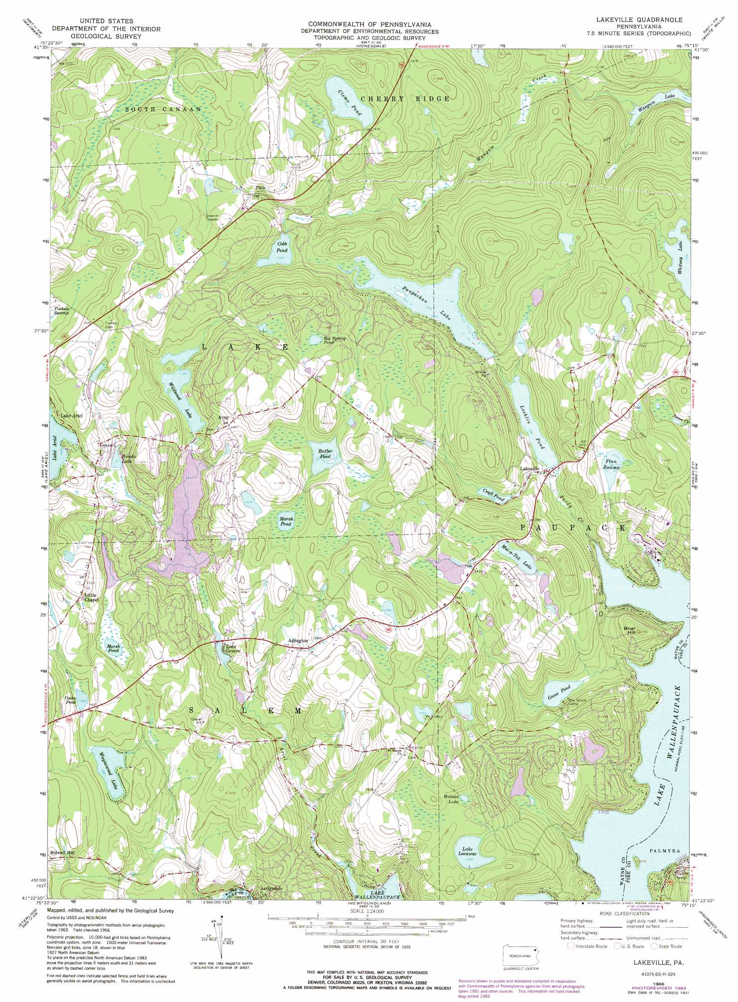
Lakeville Topo Map Pennsylvania
To zoom in, hover over the map of Lakeville
USGS Topo Quad 41075d3 - 1:24,000 scale
| Topo Map Name: | Lakeville |
| USGS Topo Quad ID: | 41075d3 |
| Print Size: | ca. 21 1/4" wide x 27" high |
| Southeast Coordinates: | 41.375° N latitude / 75.25° W longitude |
| Map Center Coordinates: | 41.4375° N latitude / 75.3125° W longitude |
| U.S. State: | PA |
| Filename: | o41075d3.jpg |
| Download Map JPG Image: | Lakeville topo map 1:24,000 scale |
| Map Type: | Topographic |
| Topo Series: | 7.5´ |
| Map Scale: | 1:24,000 |
| Source of Map Images: | United States Geological Survey (USGS) |
| Alternate Map Versions: |
Lakeville PA 1966, updated 1967 Download PDF Buy paper map Lakeville PA 1966, updated 1974 Download PDF Buy paper map Lakeville PA 1966, updated 1983 Download PDF Buy paper map Lakeville PA 1994, updated 1996 Download PDF Buy paper map Lakeville PA 2010 Download PDF Buy paper map Lakeville PA 2013 Download PDF Buy paper map Lakeville PA 2016 Download PDF Buy paper map |
1:24,000 Topo Quads surrounding Lakeville
Clifford |
Forest City |
Aldenville |
Galilee |
Damascus |
Carbondale |
Waymart |
Honesdale |
White Mills |
Narrowsburg |
Olyphant |
Lake Ariel |
Lakeville |
Hawley |
Rowland |
Moscow |
Sterling |
Newfoundland |
Promised Land |
Pecks Pond |
Thornhurst |
Tobyhanna |
Buck Hill Falls |
Skytop |
Twelvemile Pond |
> Back to 41075a1 at 1:100,000 scale
> Back to 41074a1 at 1:250,000 scale
> Back to U.S. Topo Maps home
Lakeville topo map: Gazetteer
Lakeville: Dams
Beaver Lake Dam elevation 380m 1246′C H Mack Dam elevation 404m 1325′
Craft Pond Dam elevation 409m 1341′
Croft Dam elevation 403m 1322′
Deer Lake Dam elevation 407m 1335′
Hazzard Dam elevation 422m 1384′
Herrman Dam elevation 397m 1302′
Janoske Dam elevation 439m 1440′
Lake Ariel Dam elevation 435m 1427′
Lake Clemo Dam elevation 430m 1410′
Lake Ellyn Dam elevation 462m 1515′
Lake Moc a tek Dam elevation 413m 1354′
Lake Paupackan Dam elevation 404m 1325′
Locklin Pond Dam elevation 385m 1263′
Mang Dam elevation 374m 1227′
Roaming Woods Lake Dam elevation 401m 1315′
Wildwood Lake Dam elevation 413m 1354′
Lakeville: Islands
Kipp Island elevation 366m 1200′Lakeville: Lakes
Big Spring Pond elevation 442m 1450′Butler Pond elevation 438m 1437′
Cobb Pond elevation 409m 1341′
Goose Pond elevation 380m 1246′
Hidden Lake elevation 437m 1433′
Kuehners Pond elevation 445m 1459′
Locklin Pond elevation 384m 1259′
Marsh Pond elevation 421m 1381′
Lakeville: Populated Places
Arlington elevation 439m 1440′Avoy elevation 447m 1466′
Lakeville elevation 383m 1256′
Little Chapel elevation 452m 1482′
Pink elevation 427m 1400′
Lakeville: Reservoirs
Beaver Lake elevation 380m 1246′Brooks Lake elevation 417m 1368′
Clemo Pond elevation 431m 1414′
Cooks Pond elevation 424m 1391′
Craft Pond elevation 405m 1328′
Deer Lake elevation 407m 1335′
Lake Genero elevation 395m 1295′
Lake Lacawac elevation 436m 1430′
Mang Pond elevation 374m 1227′
Moc-a-Tek Lake elevation 414m 1358′
Paupackan Lake elevation 404m 1325′
Roaming Woods Lake elevation 401m 1315′
Waynewood Lake elevation 421m 1381′
Wildwood Lake elevation 415m 1361′
Lakeville: Streams
Ariel Creek elevation 365m 1197′Purdy Creek elevation 365m 1197′
Lakeville: Summits
Briar Hill elevation 426m 1397′Lakeville: Swamps
Finn Swamp elevation 411m 1348′Lakeville digital topo map on disk
Buy this Lakeville topo map showing relief, roads, GPS coordinates and other geographical features, as a high-resolution digital map file on DVD:
New York, Vermont, Connecticut & Western Massachusetts
Buy digital topo maps: New York, Vermont, Connecticut & Western Massachusetts