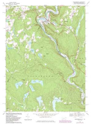
Narrowsburg Topo Map Pennsylvania
To zoom in, hover over the map of Narrowsburg
USGS Topo Quad 41075e1 - 1:24,000 scale
| Topo Map Name: | Narrowsburg |
| USGS Topo Quad ID: | 41075e1 |
| Print Size: | ca. 21 1/4" wide x 27" high |
| Southeast Coordinates: | 41.5° N latitude / 75° W longitude |
| Map Center Coordinates: | 41.5625° N latitude / 75.0625° W longitude |
| U.S. States: | PA, NY |
| Filename: | o41075e1.jpg |
| Download Map JPG Image: | Narrowsburg topo map 1:24,000 scale |
| Map Type: | Topographic |
| Topo Series: | 7.5´ |
| Map Scale: | 1:24,000 |
| Source of Map Images: | United States Geological Survey (USGS) |
| Alternate Map Versions: |
Narrowsburg NY 1968, updated 1969 Download PDF Buy paper map Narrowsburg NY 1968, updated 1983 Download PDF Buy paper map Narrowsburg NY 1968, updated 1983 Download PDF Buy paper map Narrowsburg NY 1994, updated 1995 Download PDF Buy paper map Narrowsburg NY 1997, updated 1999 Download PDF Buy paper map Narrowsburg NY 1997, updated 2002 Download PDF Buy paper map Narrowsburg NY 2010 Download PDF Buy paper map Narrowsburg NY 2013 Download PDF Buy paper map Narrowsburg NY 2016 Download PDF Buy paper map |
1:24,000 Topo Quads surrounding Narrowsburg
> Back to 41075e1 at 1:100,000 scale
> Back to 41074a1 at 1:250,000 scale
> Back to U.S. Topo Maps home
Narrowsburg topo map: Gazetteer
Narrowsburg: Capes
Point Peter elevation 399m 1309′Narrowsburg: Dams
Cobey Dam elevation 332m 1089′Forest Lake Dam elevation 414m 1358′
Perkins Pond Dam elevation 335m 1099′
Westcolang Lake Dam elevation 338m 1108′
Narrowsburg: Falls
Darbytown Falls elevation 271m 889′Narrowsburg: Lakes
Clarks Pond elevation 326m 1069′Corilla Lake elevation 384m 1259′
Little Beach Pond elevation 375m 1230′
Little Teedyuskung Lake elevation 387m 1269′
Luxton Lake elevation 281m 921′
Panther Lake elevation 350m 1148′
Welcome Lake elevation 350m 1148′
Wolf Lake elevation 395m 1295′
Narrowsburg: Populated Places
Atco elevation 294m 964′Branningville elevation 304m 997′
Darbytown elevation 202m 662′
East Berlin elevation 362m 1187′
Fawn Lake Forest elevation 394m 1292′
Forest Lake Park elevation 424m 1391′
Hunts Corner elevation 274m 898′
Lava elevation 378m 1240′
Masthope elevation 211m 692′
Masthope Rapids elevation 348m 1141′
Narrowsburg elevation 202m 662′
Tusten elevation 210m 688′
Westcolang elevation 197m 646′
Westcolang Park elevation 339m 1112′
Narrowsburg: Reservoirs
Cobey Pond elevation 330m 1082′Feagles Lake elevation 222m 728′
Forest Lake elevation 381m 1250′
Perkins Pond elevation 334m 1095′
Teedyuskung Lake elevation 386m 1266′
Westcolang Pond elevation 312m 1023′
Narrowsburg: Ridges
Rattlesnake Ridge elevation 394m 1292′Narrowsburg: Streams
Beach Lake Creek elevation 321m 1053′East Branch Tenmile River elevation 230m 754′
Grassy Swamp Brook elevation 190m 623′
Masthope Creek elevation 189m 620′
Peggy Run elevation 201m 659′
Rattlesnake Creek elevation 292m 958′
Tenmile River elevation 195m 639′
Westcolang Creek elevation 184m 603′
Wolf Lake Run elevation 316m 1036′
Narrowsburg: Summits
Deep Hollow Hill elevation 380m 1246′Narrowsburg: Swamps
Cattail Swamp elevation 358m 1174′Rowland Swamp elevation 363m 1190′
Spruce Swamp elevation 356m 1167′
Narrowsburg digital topo map on disk
Buy this Narrowsburg topo map showing relief, roads, GPS coordinates and other geographical features, as a high-resolution digital map file on DVD:
New York, Vermont, Connecticut & Western Massachusetts
Buy digital topo maps: New York, Vermont, Connecticut & Western Massachusetts


