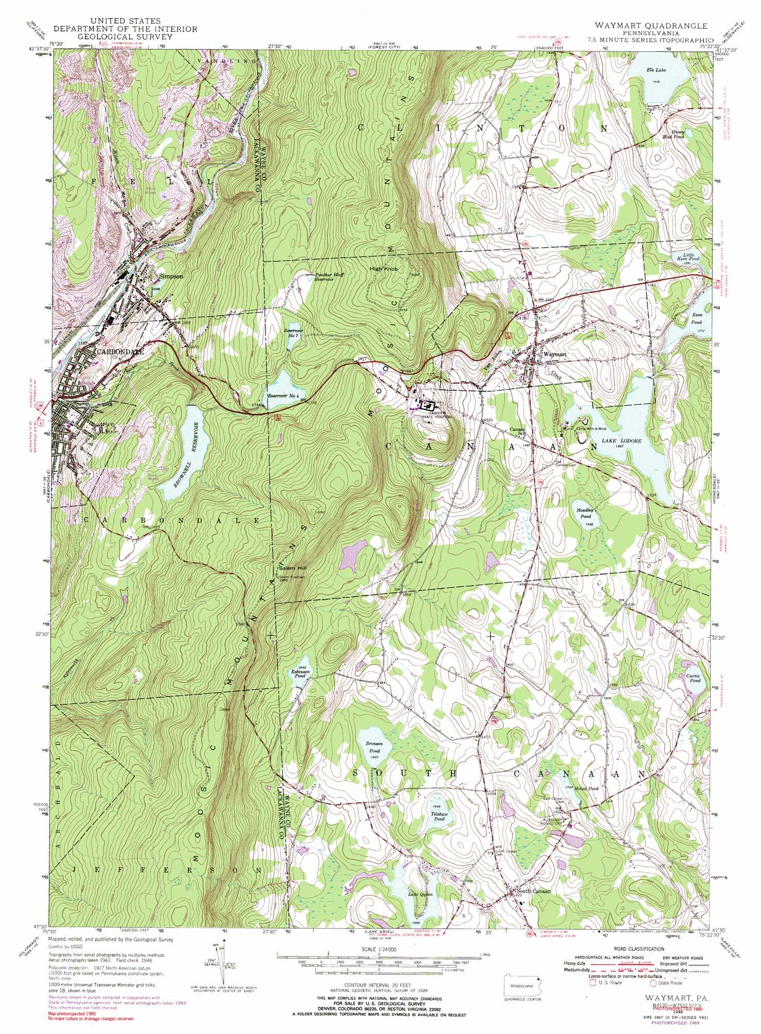
Waymart Topo Map Pennsylvania
To zoom in, hover over the map of Waymart
USGS Topo Quad 41075e4 - 1:24,000 scale
| Topo Map Name: | Waymart |
| USGS Topo Quad ID: | 41075e4 |
| Print Size: | ca. 21 1/4" wide x 27" high |
| Southeast Coordinates: | 41.5° N latitude / 75.375° W longitude |
| Map Center Coordinates: | 41.5625° N latitude / 75.4375° W longitude |
| U.S. State: | PA |
| Filename: | o41075e4.jpg |
| Download Map JPG Image: | Waymart topo map 1:24,000 scale |
| Map Type: | Topographic |
| Topo Series: | 7.5´ |
| Map Scale: | 1:24,000 |
| Source of Map Images: | United States Geological Survey (USGS) |
| Alternate Map Versions: |
Waymart PA 1946, updated 1968 Download PDF Buy paper map Waymart PA 1946, updated 1971 Download PDF Buy paper map Waymart PA 1946, updated 1976 Download PDF Buy paper map Waymart PA 1946, updated 1991 Download PDF Buy paper map Waymart PA 1948 Download PDF Buy paper map Waymart PA 1948 Download PDF Buy paper map Waymart PA 1994, updated 1996 Download PDF Buy paper map Waymart PA 1999, updated 2001 Download PDF Buy paper map Waymart PA 2010 Download PDF Buy paper map Waymart PA 2013 Download PDF Buy paper map Waymart PA 2016 Download PDF Buy paper map |
1:24,000 Topo Quads surrounding Waymart
Harford |
Thompson |
Orson |
Lake Como |
Long Eddy |
Lenoxville |
Clifford |
Forest City |
Aldenville |
Galilee |
Dalton |
Carbondale |
Waymart |
Honesdale |
White Mills |
Scranton |
Olyphant |
Lake Ariel |
Lakeville |
Hawley |
Avoca |
Moscow |
Sterling |
Newfoundland |
Promised Land |
> Back to 41075e1 at 1:100,000 scale
> Back to 41074a1 at 1:250,000 scale
> Back to U.S. Topo Maps home
Waymart topo map: Gazetteer
Waymart: Airports
Flying Fox Airport elevation 443m 1453′Kellachow Landing Strip elevation 428m 1404′
Reed Airport elevation 401m 1315′
Waymart: Dams
Belmont Dam elevation 377m 1236′Bronson Pond Dam elevation 427m 1400′
Brownell Dam elevation 485m 1591′
Brunsons Pond Dam elevation 426m 1397′
Carbondale Number Four Dam elevation 532m 1745′
Hetzell Pond Dam elevation 410m 1345′
Lake Ladore Dam elevation 417m 1368′
Lake Quinn Dam elevation 410m 1345′
Little Keen Pond Dam elevation 393m 1289′
Machell Mill Dam elevation 407m 1335′
Reservoir Number Seven Dam elevation 549m 1801′
Saint Tikhons Dam elevation 419m 1374′
Waymart: Lakes
Lake Quinn elevation 411m 1348′Waymart: Mines
Jones and Voyles Mine (historical) elevation 402m 1318′Waymart: Parks
State Game Lands Number 300 elevation 415m 1361′Waymart: Populated Places
Simpson elevation 347m 1138′South Canaan elevation 434m 1423′
Waymart elevation 426m 1397′
Whites Crossing elevation 414m 1358′
Waymart: Ranges
Moosic Mountains elevation 686m 2250′Waymart: Reservoirs
Belmont Lake elevation 377m 1236′Belmont Reservoir elevation 382m 1253′
Bronson Pond elevation 427m 1400′
Brownell Reservoir elevation 474m 1555′
Carbondale Number Four Reservoir elevation 532m 1745′
Curtis Pond elevation 417m 1368′
Deerfield Pond elevation 575m 1886′
Elk Lake elevation 431m 1414′
Hetzel Pond elevation 410m 1345′
Hoadley Pond elevation 436m 1430′
Honey Mud Pond elevation 410m 1345′
Lake Ladore elevation 417m 1368′
Little Keen Pond elevation 391m 1282′
Number Four Reservoir elevation 532m 1745′
Number Seven Reservoir elevation 553m 1814′
Panther Bluff Pond elevation 579m 1899′
Reservoir Number Seven elevation 549m 1801′
Robinson Pond elevation 500m 1640′
Telshaw Pond elevation 428m 1404′
Waymart: Streams
Coal Brook elevation 340m 1115′Wilson Creek elevation 345m 1131′
Waymart: Summits
High Knob elevation 690m 2263′Salem Hill elevation 686m 2250′
Waymart digital topo map on disk
Buy this Waymart topo map showing relief, roads, GPS coordinates and other geographical features, as a high-resolution digital map file on DVD:
New York, Vermont, Connecticut & Western Massachusetts
Buy digital topo maps: New York, Vermont, Connecticut & Western Massachusetts