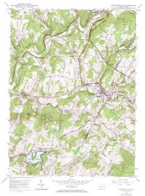
Factoryville Topo Map Pennsylvania
To zoom in, hover over the map of Factoryville
USGS Topo Quad 41075e7 - 1:24,000 scale
| Topo Map Name: | Factoryville |
| USGS Topo Quad ID: | 41075e7 |
| Print Size: | ca. 21 1/4" wide x 27" high |
| Southeast Coordinates: | 41.5° N latitude / 75.75° W longitude |
| Map Center Coordinates: | 41.5625° N latitude / 75.8125° W longitude |
| U.S. State: | PA |
| Filename: | o41075e7.jpg |
| Download Map JPG Image: | Factoryville topo map 1:24,000 scale |
| Map Type: | Topographic |
| Topo Series: | 7.5´ |
| Map Scale: | 1:24,000 |
| Source of Map Images: | United States Geological Survey (USGS) |
| Alternate Map Versions: |
Factoryville PA 1946, updated 1968 Download PDF Buy paper map Factoryville PA 1946, updated 1971 Download PDF Buy paper map Factoryville PA 1948 Download PDF Buy paper map Factoryville PA 1948 Download PDF Buy paper map Factoryville PA 1994, updated 1996 Download PDF Buy paper map Factoryville PA 2010 Download PDF Buy paper map Factoryville PA 2013 Download PDF Buy paper map Factoryville PA 2016 Download PDF Buy paper map |
1:24,000 Topo Quads surrounding Factoryville
> Back to 41075e1 at 1:100,000 scale
> Back to 41074a1 at 1:250,000 scale
> Back to U.S. Topo Maps home
Factoryville topo map: Gazetteer
Factoryville: Airports
Hillover/Sekol Airport elevation 322m 1056′Seamans Field elevation 341m 1118′
Factoryville: Dams
Lake Sheridan Dam elevation 316m 1036′Ross Dam elevation 290m 951′
Saddle Lake Dam elevation 344m 1128′
Sweeney Dam elevation 359m 1177′
Winola Mill Pond Dam elevation 298m 977′
Factoryville: Lakes
Lake Sheridan elevation 299m 980′Factoryville: Parks
Christy Mathewson Field elevation 257m 843′Moore Hall Alumni Garden elevation 268m 879′
Ned Boehm Field elevation 259m 849′
Factoryville: Populated Places
Bardwell elevation 223m 731′Carpenter Hollow elevation 245m 803′
East Lemon elevation 213m 698′
Factoryville elevation 250m 820′
La Plume elevation 271m 889′
Lake Winola elevation 347m 1138′
Starkville elevation 212m 695′
Walls Corners elevation 307m 1007′
Factoryville: Post Offices
Lake Winola Post Office elevation 328m 1076′Factoryville: Reservoirs
Flow Pond elevation 263m 862′Lake Winola elevation 298m 977′
Pedrick Pond elevation 359m 1177′
Shibley Pond elevation 342m 1122′
Spencer Pond elevation 352m 1154′
Sweeny Pond elevation 349m 1145′
Factoryville: Streams
Field Brook elevation 214m 702′Horton Creek elevation 216m 708′
Martins Creek elevation 217m 711′
Monroe Creek elevation 206m 675′
Oxbow Creek elevation 199m 652′
South Branch Tunkhannock Creek elevation 192m 629′
Trout Brook elevation 224m 734′
Factoryville: Summits
Bunker Hill elevation 361m 1184′Casterline Hill elevation 369m 1210′
East Mountain elevation 475m 1558′
Greenwood Hill elevation 360m 1181′
Lake Sheridan Hill elevation 365m 1197′
Middle Mountain elevation 446m 1463′
Thomas Hill elevation 385m 1263′
Tunnel Hill elevation 345m 1131′
Wilbur Hill elevation 504m 1653′
Wright Hill elevation 338m 1108′
Factoryville: Swamps
Broadbent Swamp elevation 295m 967′Stantontown Swamp elevation 331m 1085′
Stark Swamp elevation 205m 672′
Factoryville: Valleys
Lithia Valley elevation 225m 738′Factoryville digital topo map on disk
Buy this Factoryville topo map showing relief, roads, GPS coordinates and other geographical features, as a high-resolution digital map file on DVD:
New York, Vermont, Connecticut & Western Massachusetts
Buy digital topo maps: New York, Vermont, Connecticut & Western Massachusetts


