Forest City Topo Map Pennsylvania
To zoom in, hover over the map of Forest City
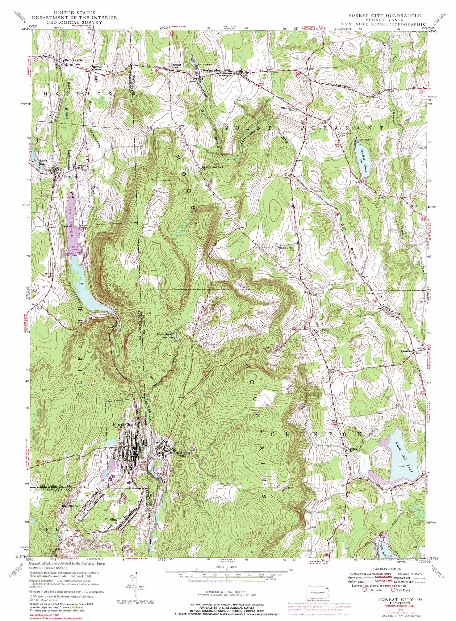
USGS Topo Quad 41075f4 - 1:24,000 scale
| Topo Map Name: | Forest City |
| USGS Topo Quad ID: | 41075f4 |
| Print Size: | ca. 21 1/4" wide x 27" high |
| Southeast Coordinates: | 41.625° N latitude / 75.375° W longitude |
| Map Center Coordinates: | 41.6875° N latitude / 75.4375° W longitude |
| U.S. State: | PA |
| Filename: | o41075f4.jpg |
| Download Map JPG Image: | Forest City topo map 1:24,000 scale |
| Map Type: | Topographic |
| Topo Series: | 7.5´ |
| Map Scale: | 1:24,000 |
| Source of Map Images: | United States Geological Survey (USGS) |
| Alternate Map Versions: |
Forest City PA 1946, updated 1966 Download PDF Buy paper map Forest City PA 1946, updated 1971 Download PDF Buy paper map Forest City PA 1946, updated 1988 Download PDF Buy paper map Forest City PA 1949 Download PDF Buy paper map Forest City PA 1949 Download PDF Buy paper map Forest City PA 1994, updated 1996 Download PDF Buy paper map Forest City PA 2010 Download PDF Buy paper map Forest City PA 2013 Download PDF Buy paper map Forest City PA 2016 Download PDF Buy paper map |
1:24,000 Topo Quads surrounding Forest City
Great Bend |
Susquehanna |
Starrucca |
Hancock |
Fishs Eddy |
Harford |
Thompson |
Orson |
Lake Como |
Long Eddy |
Lenoxville |
Clifford |
Forest City |
Aldenville |
Galilee |
Dalton |
Carbondale |
Waymart |
Honesdale |
White Mills |
Scranton |
Olyphant |
Lake Ariel |
Lakeville |
Hawley |
> Back to 41075e1 at 1:100,000 scale
> Back to 41074a1 at 1:250,000 scale
> Back to U.S. Topo Maps home
Forest City topo map: Gazetteer
Forest City: Dams
Brace Brook Dam elevation 570m 1870′Elk Lake Dam elevation 435m 1427′
Hankins Pond Dam elevation 447m 1466′
Lewis Lake Dam elevation 525m 1722′
Stillwater Dam elevation 481m 1578′
Stillwater Reservoir Dam elevation 494m 1620′
White Oak Pond Dam elevation 416m 1364′
Forest City: Mines
Clifford Shaft elevation 497m 1630′Old Forest City Shaft elevation 471m 1545′
Forest City: Populated Places
Belmont Corner elevation 614m 2014′Cascade elevation 502m 1646′
Creamton elevation 381m 1250′
Forest City elevation 480m 1574′
Forest City Station elevation 460m 1509′
Herrick Center elevation 523m 1715′
Herrick Corner elevation 512m 1679′
Pleasant Mount elevation 604m 1981′
Richmondale elevation 519m 1702′
Union Dale elevation 515m 1689′
Vandling elevation 492m 1614′
Forest City: Reservoirs
Brace Brook Reservoir elevation 541m 1774′Hankins Pond elevation 442m 1450′
Lewis Lake elevation 525m 1722′
Stillwater Lake elevation 479m 1571′
White Oak Pond elevation 419m 1374′
Forest City: Streams
Brace Brook elevation 452m 1482′Clarks Creek elevation 430m 1410′
East Branch Lackawanna River elevation 479m 1571′
Fiddle Lake Creek elevation 485m 1591′
Johnson Creek elevation 384m 1259′
Meredith Brook elevation 432m 1417′
Rogers Brook elevation 429m 1407′
West Branch Lackawanna River elevation 481m 1578′
Forest City: Summits
Lackawanna Mountain elevation 677m 2221′Forest City digital topo map on disk
Buy this Forest City topo map showing relief, roads, GPS coordinates and other geographical features, as a high-resolution digital map file on DVD:
New York, Vermont, Connecticut & Western Massachusetts
Buy digital topo maps: New York, Vermont, Connecticut & Western Massachusetts