Callicoon Topo Map New York
To zoom in, hover over the map of Callicoon
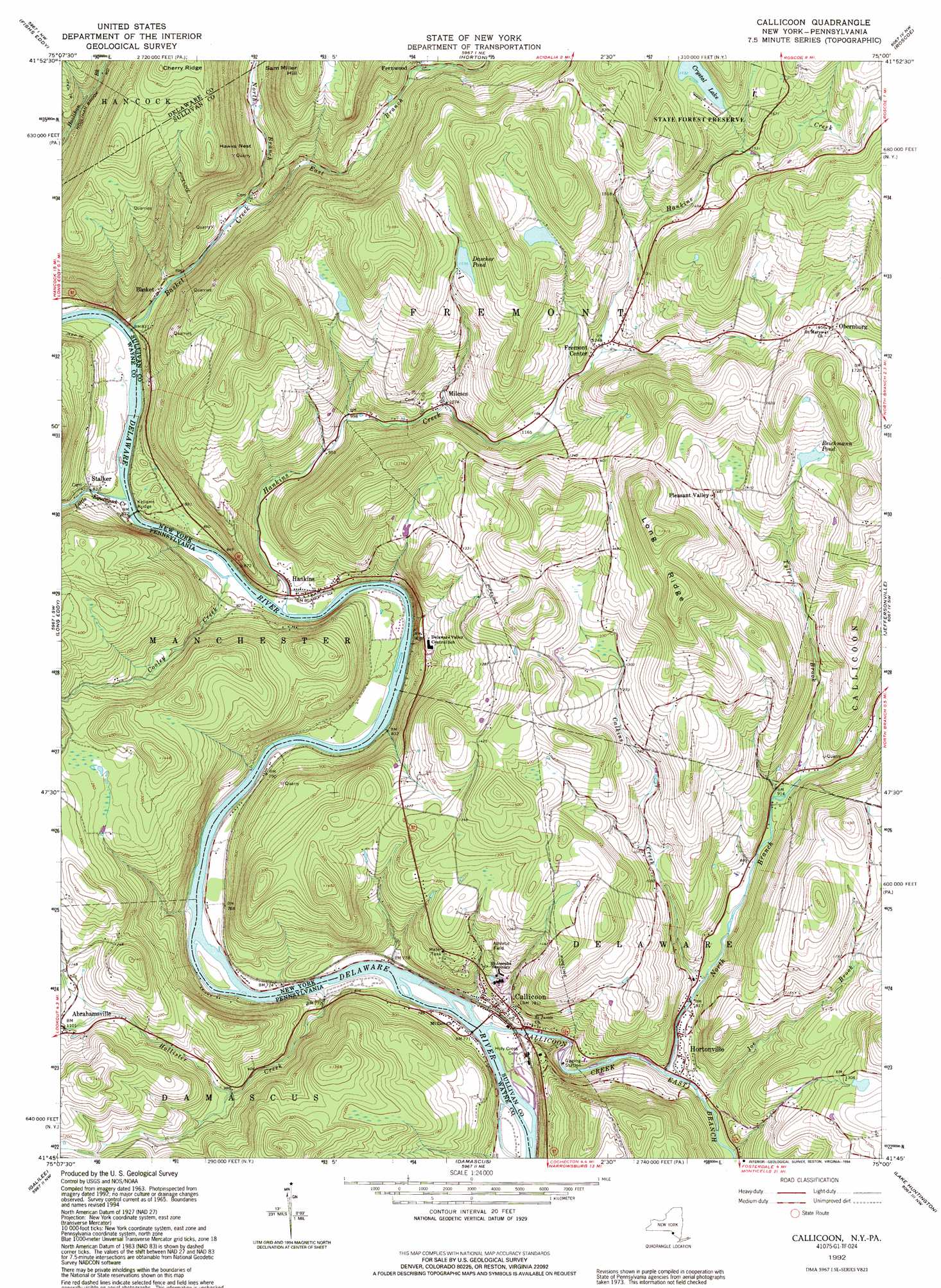
USGS Topo Quad 41075g1 - 1:24,000 scale
| Topo Map Name: | Callicoon |
| USGS Topo Quad ID: | 41075g1 |
| Print Size: | ca. 21 1/4" wide x 27" high |
| Southeast Coordinates: | 41.75° N latitude / 75° W longitude |
| Map Center Coordinates: | 41.8125° N latitude / 75.0625° W longitude |
| U.S. States: | NY, PA |
| Filename: | o41075g1.jpg |
| Download Map JPG Image: | Callicoon topo map 1:24,000 scale |
| Map Type: | Topographic |
| Topo Series: | 7.5´ |
| Map Scale: | 1:24,000 |
| Source of Map Images: | United States Geological Survey (USGS) |
| Alternate Map Versions: |
Callicoon NY 1965, updated 1967 Download PDF Buy paper map Callicoon NY 1965, updated 1973 Download PDF Buy paper map Callicoon NY 1965, updated 1984 Download PDF Buy paper map Callicoon NY 1992, updated 1994 Download PDF Buy paper map Callicoon NY 2010 Download PDF Buy paper map Callicoon NY 2013 Download PDF Buy paper map Callicoon NY 2016 Download PDF Buy paper map |
1:24,000 Topo Quads surrounding Callicoon
Cannonsville Reservoir |
Readburn |
Corbett |
Downsville |
Lewbeach |
Hancock |
Fishs Eddy |
Horton |
Roscoe |
Livingston Manor |
Lake Como |
Long Eddy |
Callicoon |
Jeffersonville |
Liberty West |
Aldenville |
Galilee |
Damascus |
Lake Huntington |
White Lake |
Honesdale |
White Mills |
Narrowsburg |
Eldred |
Highland Lake |
> Back to 41075e1 at 1:100,000 scale
> Back to 41074a1 at 1:250,000 scale
> Back to U.S. Topo Maps home
Callicoon topo map: Gazetteer
Callicoon: Bridges
Kellams Bridge elevation 238m 780′Kellams Bridge elevation 238m 780′
Callicoon: Lakes
Crystal Lake elevation 528m 1732′Dascher Pond elevation 468m 1535′
Reichmann Pond elevation 460m 1509′
Callicoon: Populated Places
Abrahamsville elevation 338m 1108′Basket elevation 260m 853′
Callicoon elevation 258m 846′
Fernwood elevation 368m 1207′
Fremont Center elevation 378m 1240′
Hankins elevation 246m 807′
Hortonville elevation 245m 803′
Mileses elevation 330m 1082′
Obernburg elevation 505m 1656′
Pleasant Valley elevation 446m 1463′
Stalker elevation 250m 820′
Callicoon: Ridges
Long Ridge elevation 534m 1751′Callicoon: Streams
Basket Creek elevation 248m 813′Calkins Creek elevation 246m 807′
Callicoon Creek elevation 219m 718′
Cooley Creek elevation 238m 780′
East Branch Basket Creek elevation 291m 954′
East Branch Callicoon Creek elevation 232m 761′
Hankins Creek elevation 238m 780′
Hollister Creek elevation 226m 741′
Joe Brook elevation 240m 787′
Little Equinunk Creek elevation 238m 780′
North Branch Basket Creek elevation 292m 958′
North Branch Callicoon Creek elevation 232m 761′
Tyler Brook elevation 286m 938′
Callicoon: Summits
Hawks Nest elevation 545m 1788′Sam Miller Hill elevation 535m 1755′
Callicoon digital topo map on disk
Buy this Callicoon topo map showing relief, roads, GPS coordinates and other geographical features, as a high-resolution digital map file on DVD:
New York, Vermont, Connecticut & Western Massachusetts
Buy digital topo maps: New York, Vermont, Connecticut & Western Massachusetts