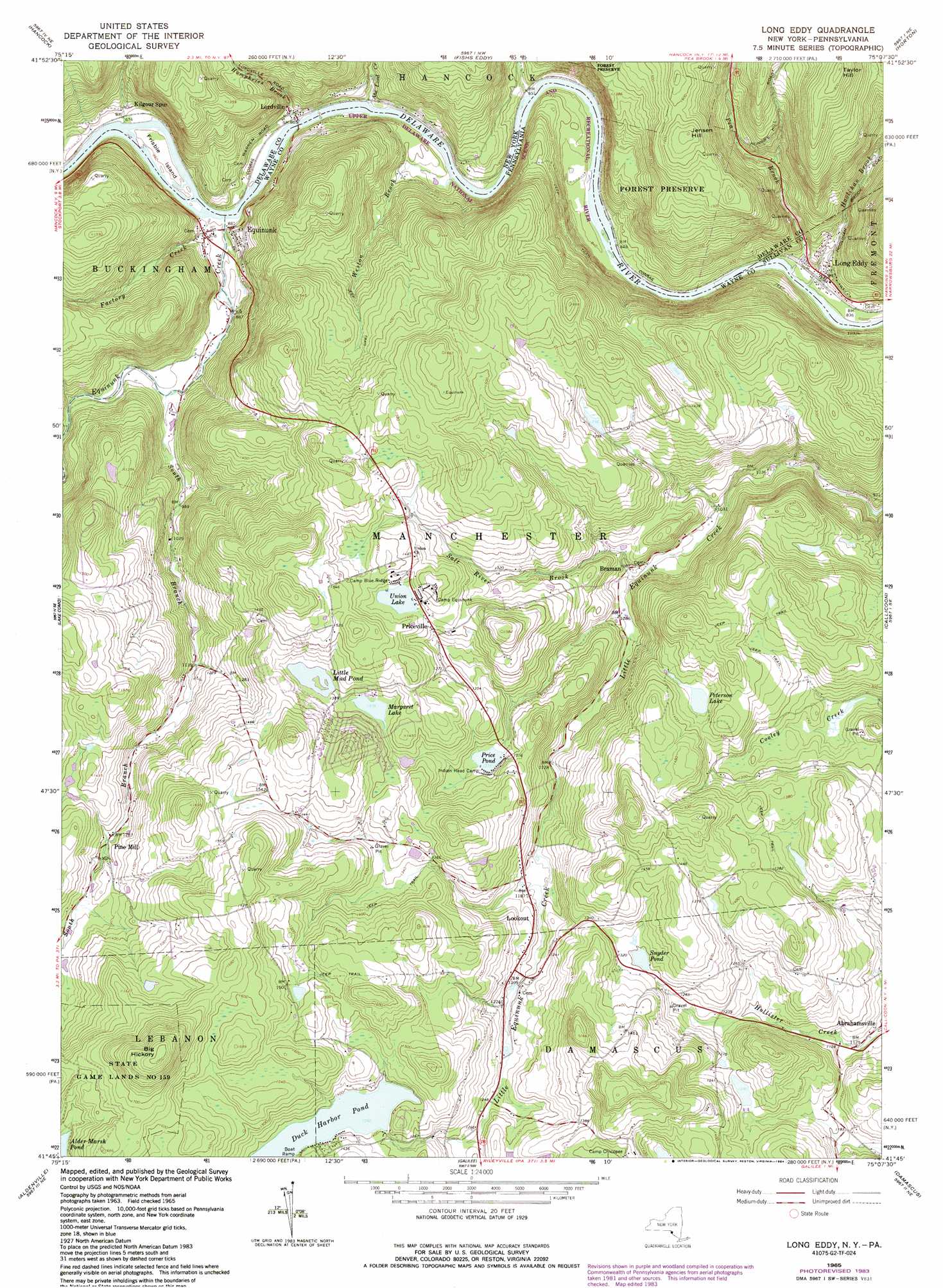
Long Eddy Topo Map Pennsylvania
To zoom in, hover over the map of Long Eddy
USGS Topo Quad 41075g2 - 1:24,000 scale
| Topo Map Name: | Long Eddy |
| USGS Topo Quad ID: | 41075g2 |
| Print Size: | ca. 21 1/4" wide x 27" high |
| Southeast Coordinates: | 41.75° N latitude / 75.125° W longitude |
| Map Center Coordinates: | 41.8125° N latitude / 75.1875° W longitude |
| U.S. States: | PA, NY |
| Filename: | o41075g2.jpg |
| Download Map JPG Image: | Long Eddy topo map 1:24,000 scale |
| Map Type: | Topographic |
| Topo Series: | 7.5´ |
| Map Scale: | 1:24,000 |
| Source of Map Images: | United States Geological Survey (USGS) |
| Alternate Map Versions: |
Long Eddy NY 1965, updated 1967 Download PDF Buy paper map Long Eddy NY 1965, updated 1974 Download PDF Buy paper map Long Eddy NY 1965, updated 1984 Download PDF Buy paper map Long Eddy NY 1992, updated 1995 Download PDF Buy paper map Long Eddy NY 2010 Download PDF Buy paper map Long Eddy NY 2013 Download PDF Buy paper map Long Eddy NY 2016 Download PDF Buy paper map |
1:24,000 Topo Quads surrounding Long Eddy
Deposit |
Cannonsville Reservoir |
Readburn |
Corbett |
Downsville |
Starrucca |
Hancock |
Fishs Eddy |
Horton |
Roscoe |
Orson |
Lake Como |
Long Eddy |
Callicoon |
Jeffersonville |
Forest City |
Aldenville |
Galilee |
Damascus |
Lake Huntington |
Waymart |
Honesdale |
White Mills |
Narrowsburg |
Eldred |
> Back to 41075e1 at 1:100,000 scale
> Back to 41074a1 at 1:250,000 scale
> Back to U.S. Topo Maps home
Long Eddy topo map: Gazetteer
Long Eddy: Dams
Duck Harbor Pond Dam elevation 427m 1400′Little Mud Pond Dam elevation 429m 1407′
Saw Mill Dam elevation 402m 1318′
Long Eddy: Islands
Frisbie Island elevation 262m 859′Long Eddy: Lakes
Little Mud Pond elevation 428m 1404′Margaret Lake elevation 417m 1368′
Peterson Lake elevation 405m 1328′
Price Pond elevation 386m 1266′
Snyder Pond elevation 394m 1292′
Union Lake elevation 434m 1423′
Long Eddy: Populated Places
Equinunk elevation 271m 889′Hilltown elevation 372m 1220′
Long Eddy elevation 258m 846′
Lordville elevation 267m 875′
Pine Mill elevation 391m 1282′
Priceville elevation 428m 1404′
Long Eddy: Reservoirs
Duck Harbor Pond elevation 424m 1391′Long Eddy: Streams
Abe Lord Creek elevation 252m 826′Bouchoux Brook elevation 256m 839′
Equinunk Creek elevation 256m 839′
Factory Creek elevation 262m 859′
Hoolihan Brook elevation 245m 803′
Humphries Brook elevation 262m 859′
Pea Brook elevation 249m 816′
Salt River Brook elevation 331m 1085′
South Branch Equinunk Creek elevation 403m 1322′
Weston Brook elevation 250m 820′
Long Eddy: Summits
Big Hickory elevation 611m 2004′Jensen Hill elevation 513m 1683′
Long Eddy digital topo map on disk
Buy this Long Eddy topo map showing relief, roads, GPS coordinates and other geographical features, as a high-resolution digital map file on DVD:
New York, Vermont, Connecticut & Western Massachusetts
Buy digital topo maps: New York, Vermont, Connecticut & Western Massachusetts