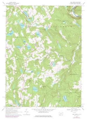
Lake Como Topo Map Pennsylvania
To zoom in, hover over the map of Lake Como
USGS Topo Quad 41075g3 - 1:24,000 scale
| Topo Map Name: | Lake Como |
| USGS Topo Quad ID: | 41075g3 |
| Print Size: | ca. 21 1/4" wide x 27" high |
| Southeast Coordinates: | 41.75° N latitude / 75.25° W longitude |
| Map Center Coordinates: | 41.8125° N latitude / 75.3125° W longitude |
| U.S. States: | PA, NY |
| Filename: | o41075g3.jpg |
| Download Map JPG Image: | Lake Como topo map 1:24,000 scale |
| Map Type: | Topographic |
| Topo Series: | 7.5´ |
| Map Scale: | 1:24,000 |
| Source of Map Images: | United States Geological Survey (USGS) |
| Alternate Map Versions: |
Lake Como PA 1968, updated 1970 Download PDF Buy paper map Lake Como PA 1968, updated 1978 Download PDF Buy paper map Lake Como PA 1992, updated 1995 Download PDF Buy paper map Lake Como PA 2010 Download PDF Buy paper map Lake Como PA 2013 Download PDF Buy paper map Lake Como PA 2016 Download PDF Buy paper map |
1:24,000 Topo Quads surrounding Lake Como
> Back to 41075e1 at 1:100,000 scale
> Back to 41074a1 at 1:250,000 scale
> Back to U.S. Topo Maps home
Lake Como topo map: Gazetteer
Lake Como: Dams
Howell Pond Dam elevation 424m 1391′Kinneyville Pond Dam elevation 414m 1358′
Lake Charlotte Dam elevation 377m 1236′
Lake Como Dam elevation 460m 1509′
Lake Hamilton Dam elevation 378m 1240′
Lake Underwood Dam elevation 470m 1541′
Lower Twin Dam elevation 454m 1489′
Lower Twin Lake Dam elevation 456m 1496′
Upper Twin Dam elevation 471m 1545′
Lake Como: Gaps
The Notch elevation 461m 1512′Lake Como: Lakes
Fork Mountain Pond elevation 466m 1528′High Lake elevation 460m 1509′
Howell Pond elevation 424m 1391′
Kinneyville Pond elevation 409m 1341′
Lake Charlotte elevation 375m 1230′
Little Biglow Lake elevation 486m 1594′
Long Pond elevation 454m 1489′
Mud Pond elevation 456m 1496′
Nabbys Lake elevation 368m 1207′
Rock Lake elevation 479m 1571′
Sly Lake elevation 459m 1505′
Spruce Pond elevation 466m 1528′
Underwood Lake elevation 470m 1541′
Upper Twin Lake elevation 472m 1548′
Upper Woods Pond elevation 455m 1492′
Wallerville Pond elevation 416m 1364′
Lake Como: Parks
State Game Lands Number 159 elevation 500m 1640′Lake Como: Populated Places
Dillontown elevation 276m 905′East Spruce elevation 475m 1558′
High Lake elevation 385m 1263′
Lake Como elevation 463m 1519′
Preston Corner elevation 467m 1532′
Rudes Corner elevation 434m 1423′
Lake Como: Reservoirs
Lake Como elevation 458m 1502′Lake Hamilton elevation 378m 1240′
Lake Underwood elevation 470m 1541′
Lower Twin Lake elevation 454m 1489′
Lake Como: Streams
Crooked Creek elevation 329m 1079′Kinneyville Creek elevation 305m 1000′
Riley Creek elevation 419m 1374′
Lake Como: Summits
Church Hill elevation 586m 1922′Mansfield Hill elevation 580m 1902′
Lake Como digital topo map on disk
Buy this Lake Como topo map showing relief, roads, GPS coordinates and other geographical features, as a high-resolution digital map file on DVD:
New York, Vermont, Connecticut & Western Massachusetts
Buy digital topo maps: New York, Vermont, Connecticut & Western Massachusetts


