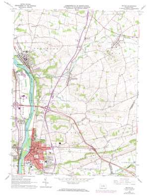
Milton Topo Map Pennsylvania
To zoom in, hover over the map of Milton
USGS Topo Quad 41076a7 - 1:24,000 scale
| Topo Map Name: | Milton |
| USGS Topo Quad ID: | 41076a7 |
| Print Size: | ca. 21 1/4" wide x 27" high |
| Southeast Coordinates: | 41° N latitude / 76.75° W longitude |
| Map Center Coordinates: | 41.0625° N latitude / 76.8125° W longitude |
| U.S. State: | PA |
| Filename: | o41076a7.jpg |
| Download Map JPG Image: | Milton topo map 1:24,000 scale |
| Map Type: | Topographic |
| Topo Series: | 7.5´ |
| Map Scale: | 1:24,000 |
| Source of Map Images: | United States Geological Survey (USGS) |
| Alternate Map Versions: |
Milton PA 1965, updated 1966 Download PDF Buy paper map Milton PA 1965, updated 1973 Download PDF Buy paper map Milton PA 1965, updated 1991 Download PDF Buy paper map Milton PA 1965, updated 1991 Download PDF Buy paper map Milton PA 1998, updated 2000 Download PDF Buy paper map Milton PA 2010 Download PDF Buy paper map Milton PA 2013 Download PDF Buy paper map Milton PA 2016 Download PDF Buy paper map |
1:24,000 Topo Quads surrounding Milton
> Back to 41076a1 at 1:100,000 scale
> Back to 41076a1 at 1:250,000 scale
> Back to U.S. Topo Maps home
Milton topo map: Gazetteer
Milton: Parks
Marsh Park elevation 142m 465′Milton State Park elevation 138m 452′
Milton: Populated Places
Central Oak Heights elevation 182m 597′Colonial Park elevation 173m 567′
Five Points elevation 175m 574′
McEwensville elevation 164m 538′
Milton elevation 154m 505′
New Columbia elevation 143m 469′
North Hills elevation 179m 587′
Springtown elevation 166m 544′
Turbotville elevation 178m 583′
Warrior Run elevation 156m 511′
Watsontown elevation 145m 475′
West Milton elevation 155m 508′
White Deer elevation 142m 465′
Milton: Ridges
Limestone Ridge elevation 236m 774′Milton: Streams
Limestone Run elevation 128m 419′Muddy Run elevation 131m 429′
Spring Run elevation 138m 452′
Warrior Run elevation 134m 439′
White Deer Creek elevation 134m 439′
Milton digital topo map on disk
Buy this Milton topo map showing relief, roads, GPS coordinates and other geographical features, as a high-resolution digital map file on DVD:
New York, Vermont, Connecticut & Western Massachusetts
Buy digital topo maps: New York, Vermont, Connecticut & Western Massachusetts


