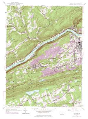
Nanticoke Topo Map Pennsylvania
To zoom in, hover over the map of Nanticoke
USGS Topo Quad 41076b1 - 1:24,000 scale
| Topo Map Name: | Nanticoke |
| USGS Topo Quad ID: | 41076b1 |
| Print Size: | ca. 21 1/4" wide x 27" high |
| Southeast Coordinates: | 41.125° N latitude / 76° W longitude |
| Map Center Coordinates: | 41.1875° N latitude / 76.0625° W longitude |
| U.S. State: | PA |
| Filename: | o41076b1.jpg |
| Download Map JPG Image: | Nanticoke topo map 1:24,000 scale |
| Map Type: | Topographic |
| Topo Series: | 7.5´ |
| Map Scale: | 1:24,000 |
| Source of Map Images: | United States Geological Survey (USGS) |
| Alternate Map Versions: |
Nanticoke PA 1954, updated 1956 Download PDF Buy paper map Nanticoke PA 1954, updated 1964 Download PDF Buy paper map Nanticoke PA 1954, updated 1969 Download PDF Buy paper map Nanticoke PA 1954, updated 1978 Download PDF Buy paper map Nanticoke PA 1954, updated 1978 Download PDF Buy paper map Nanticoke PA 1976, updated 1979 Download PDF Buy paper map Nanticoke PA 2010 Download PDF Buy paper map Nanticoke PA 2013 Download PDF Buy paper map Nanticoke PA 2016 Download PDF Buy paper map |
1:24,000 Topo Quads surrounding Nanticoke
> Back to 41076a1 at 1:100,000 scale
> Back to 41076a1 at 1:250,000 scale
> Back to U.S. Topo Maps home
Nanticoke topo map: Gazetteer
Nanticoke: Dams
Croops Dam elevation 245m 803′Keilar Dam elevation 367m 1204′
Lily Lake Dam elevation 312m 1023′
Lingertots Dam elevation 315m 1033′
Wanamie Dam elevation 275m 902′
Nanticoke: Lakes
Cranberry Pond elevation 305m 1000′Kielar Lake elevation 330m 1082′
Mud Pond elevation 330m 1082′
Najaka Pond elevation 290m 951′
Sunset Lake elevation 311m 1020′
Turkey Pond (historical) elevation 283m 928′
Nanticoke: Mines
Lee Mine elevation 205m 672′Nanticoke: Parks
State Game Lands Number 224 elevation 342m 1122′Nanticoke: Populated Places
Alden elevation 191m 626′Folstown elevation 385m 1263′
Glen Lyon elevation 206m 675′
Hallwood elevation 291m 954′
Hughs elevation 305m 1000′
Hunlock elevation 209m 685′
Hunlock Creek elevation 161m 528′
Hunlock Gardens elevation 165m 541′
Lee elevation 298m 977′
Nanticoke elevation 173m 567′
Newport Center elevation 225m 738′
Pond Hill elevation 303m 994′
Sheatown elevation 202m 662′
Slocum elevation 349m 1145′
Slocum Corners elevation 351m 1151′
Stairville elevation 300m 984′
Wanamie elevation 206m 675′
West Nanticoke elevation 159m 521′
Nanticoke: Reservoirs
Fairchild Pond elevation 300m 984′Keilar Lake elevation 367m 1204′
Lily Lake elevation 308m 1010′
Lingertots Pond elevation 315m 1033′
Nanticoke: Streams
Harveys Creek elevation 158m 518′Hunlock Creek elevation 156m 511′
Middle Branch Newport Creek elevation 181m 593′
Newport Creek elevation 153m 501′
Northbranch Newport Creek elevation 178m 583′
Reservoir Creek elevation 196m 643′
Roaring Brook elevation 230m 754′
South Branch Newport Creek elevation 169m 554′
Nanticoke: Summits
Honey Pot elevation 228m 748′Little Wilkes-Barre Mountain elevation 367m 1204′
Penobscot Mountain elevation 490m 1607′
Nanticoke: Swamps
Black Creek Swamp (historical) elevation 267m 875′Nanticoke: Tunnels
Half Penny Barn Tunnel elevation 233m 764′Nanticoke digital topo map on disk
Buy this Nanticoke topo map showing relief, roads, GPS coordinates and other geographical features, as a high-resolution digital map file on DVD:
New York, Vermont, Connecticut & Western Massachusetts
Buy digital topo maps: New York, Vermont, Connecticut & Western Massachusetts


