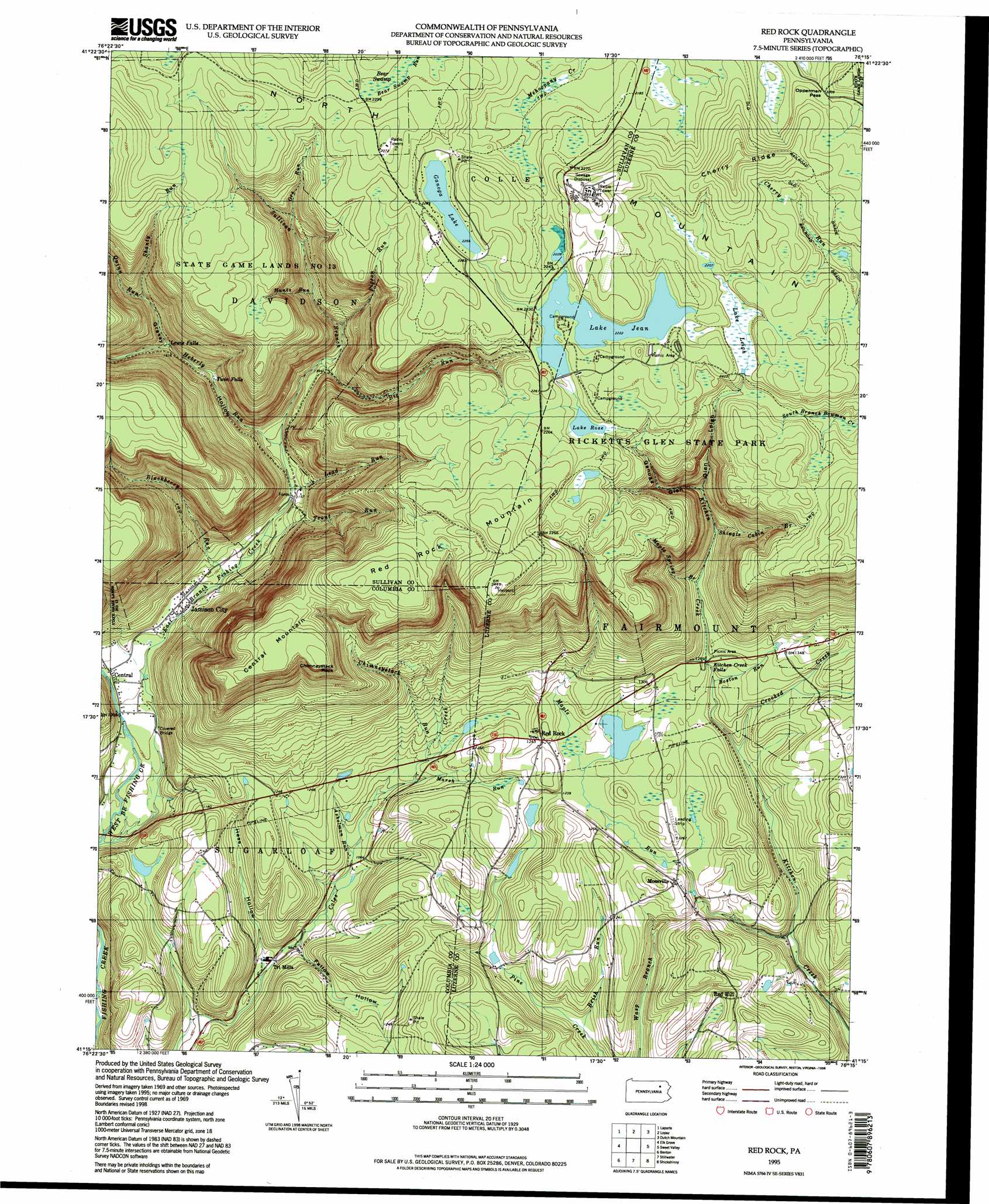
Red Rock Topo Map Pennsylvania
To zoom in, hover over the map of Red Rock
USGS Topo Quad 41076c3 - 1:24,000 scale
| Topo Map Name: | Red Rock |
| USGS Topo Quad ID: | 41076c3 |
| Print Size: | ca. 21 1/4" wide x 27" high |
| Southeast Coordinates: | 41.25° N latitude / 76.25° W longitude |
| Map Center Coordinates: | 41.3125° N latitude / 76.3125° W longitude |
| U.S. State: | PA |
| Filename: | o41076c3.jpg |
| Download Map JPG Image: | Red Rock topo map 1:24,000 scale |
| Map Type: | Topographic |
| Topo Series: | 7.5´ |
| Map Scale: | 1:24,000 |
| Source of Map Images: | United States Geological Survey (USGS) |
| Alternate Map Versions: |
Red Rock PA 1969, updated 1973 Download PDF Buy paper map Red Rock PA 1969, updated 1977 Download PDF Buy paper map Red Rock PA 1969, updated 1977 Download PDF Buy paper map Red Rock PA 1969, updated 1981 Download PDF Buy paper map Red Rock PA 1995, updated 1998 Download PDF Buy paper map Red Rock PA 2010 Download PDF Buy paper map Red Rock PA 2013 Download PDF Buy paper map Red Rock PA 2016 Download PDF Buy paper map |
1:24,000 Topo Quads surrounding Red Rock
Overton |
Dushore |
Colley |
Jenningsville |
Meshoppen |
Eagles Mere |
Laporte |
Lopez |
Dutch Mountain |
Noxen |
Sonestown |
Elk Grove |
Red Rock |
Sweet Valley |
Harveys Lake |
Lairdsville |
Benton |
Stillwater |
Shickshinny |
Nanticoke |
Millville |
Bloomsburg |
Mifflinville |
Berwick |
Sybertsville |
> Back to 41076a1 at 1:100,000 scale
> Back to 41076a1 at 1:250,000 scale
> Back to U.S. Topo Maps home
Red Rock topo map: Gazetteer
Red Rock: Areas
Boston Run Nature Area elevation 365m 1197′Glen Leigh elevation 471m 1545′
Ricketts Glen elevation 653m 2142′
Red Rock: Dams
Lake Jean Dam elevation 679m 2227′Red Rock: Falls
Adams Falls elevation 370m 1213′B Reynolds Falls elevation 499m 1637′
Cayuga Falls elevation 622m 2040′
Conestoga Falls elevation 535m 1755′
Delaware Falls elevation 556m 1824′
Erie Falls elevation 490m 1607′
F L Ricketts Falls elevation 606m 1988′
Ganoga Falls elevation 598m 1961′
Harrison Wright Falls elevation 463m 1519′
Huron Falls elevation 547m 1794′
Kitchen Creek Falls elevation 376m 1233′
Lewis Falls elevation 447m 1466′
Mohawk Falls elevation 639m 2096′
Mohican Falls elevation 545m 1788′
Murray Reynolds Falls elevation 441m 1446′
Oneida Falls elevation 648m 2125′
Onondaga Falls elevation 633m 2076′
Ozone Falls elevation 534m 1751′
R B Ricketts Falls elevation 511m 1676′
Seneca Falls elevation 566m 1856′
Shawnee Falls elevation 573m 1879′
Sheldon Reynolds Falls elevation 450m 1476′
Tuscarora Falls elevation 522m 1712′
Twin Falls elevation 417m 1368′
Wyandot Falls elevation 475m 1558′
Red Rock: Gaps
Opperman Pass elevation 673m 2208′Red Rock: Lakes
Beaver Pond elevation 372m 1220′Ganoga Lake elevation 689m 2260′
Lake Jean elevation 677m 2221′
Red Rock: Parks
Ricketts Glen State Park elevation 670m 2198′Red Rock: Pillars
The Red Rock elevation 698m 2290′Red Rock: Populated Places
Central elevation 312m 1023′Jamison City elevation 324m 1062′
Mossville elevation 387m 1269′
Red Hill elevation 377m 1236′
Red Rock elevation 387m 1269′
Tri Mills elevation 291m 954′
Red Rock: Reservoirs
Lake Jean elevation 677m 2221′Lake Rose elevation 671m 2201′
Red Rock: Ridges
Cherry Ridge elevation 750m 2460′Red Rock: Streams
Ashelman Run elevation 314m 1030′Big Run elevation 414m 1358′
Blackberry Run elevation 328m 1076′
Boston Run elevation 365m 1197′
Brish Run elevation 312m 1023′
Chimneystack Run elevation 347m 1138′
Crooked Creek elevation 344m 1128′
East Branch Fishing Creek elevation 283m 928′
Heberly Run elevation 362m 1187′
Hunts Run elevation 495m 1624′
Lead Run elevation 352m 1154′
Maple Run elevation 303m 994′
Maple Spring Brook elevation 404m 1325′
Marsh Run elevation 341m 1118′
Ore Run elevation 577m 1893′
Pigeon Run elevation 454m 1489′
Quinn Run elevation 447m 1466′
Shanty Run elevation 496m 1627′
Shingle Cabin Brook elevation 420m 1377′
Sullivan Branch elevation 362m 1187′
Trout Run elevation 339m 1112′
West Branch Fishing Creek elevation 285m 935′
Red Rock: Summits
Central Mountain elevation 685m 2247′Chimneystack Rock elevation 684m 2244′
Fritz Hill elevation 367m 1204′
Grand View elevation 745m 2444′
Red Rock Mountain elevation 721m 2365′
Red Rock: Swamps
Bear Swamp elevation 698m 2290′Lake Leigh elevation 670m 2198′
Red Rock: Trails
Old Bulldozer Road Trail elevation 648m 2125′Red Rock: Valleys
Fallow Hollow elevation 303m 994′Fishing Creek Gorge elevation 307m 1007′
Ganoga Glen elevation 481m 1578′
Glen Leigh Valley elevation 477m 1564′
Grassy Hollow elevation 365m 1197′
Hess Hollow elevation 290m 951′
Kitchen Creek Gorge elevation 365m 1197′
Midway Crevasse elevation 666m 2185′
Midway Crevasse elevation 466m 1528′
The Glens elevation 464m 1522′
Red Rock digital topo map on disk
Buy this Red Rock topo map showing relief, roads, GPS coordinates and other geographical features, as a high-resolution digital map file on DVD:
New York, Vermont, Connecticut & Western Massachusetts
Buy digital topo maps: New York, Vermont, Connecticut & Western Massachusetts