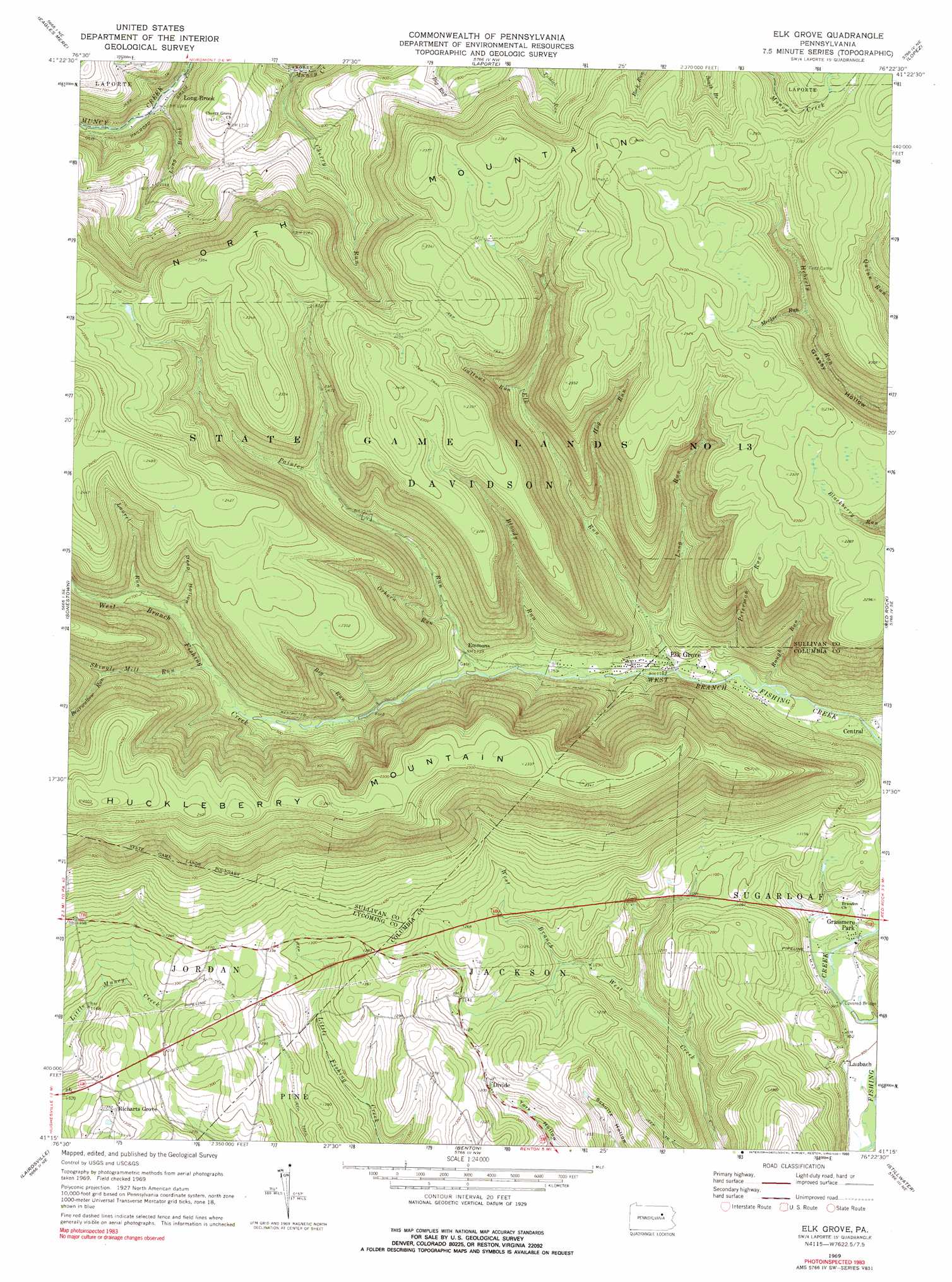
Elk Grove Topo Map Pennsylvania
To zoom in, hover over the map of Elk Grove
USGS Topo Quad 41076c4 - 1:24,000 scale
| Topo Map Name: | Elk Grove |
| USGS Topo Quad ID: | 41076c4 |
| Print Size: | ca. 21 1/4" wide x 27" high |
| Southeast Coordinates: | 41.25° N latitude / 76.375° W longitude |
| Map Center Coordinates: | 41.3125° N latitude / 76.4375° W longitude |
| U.S. State: | PA |
| Filename: | o41076c4.jpg |
| Download Map JPG Image: | Elk Grove topo map 1:24,000 scale |
| Map Type: | Topographic |
| Topo Series: | 7.5´ |
| Map Scale: | 1:24,000 |
| Source of Map Images: | United States Geological Survey (USGS) |
| Alternate Map Versions: |
Elk Grove PA 1969, updated 1973 Download PDF Buy paper map Elk Grove PA 1969, updated 1973 Download PDF Buy paper map Elk Grove PA 1969, updated 1990 Download PDF Buy paper map Elk Grove PA 2010 Download PDF Buy paper map Elk Grove PA 2013 Download PDF Buy paper map Elk Grove PA 2016 Download PDF Buy paper map |
1:24,000 Topo Quads surrounding Elk Grove
Shunk |
Overton |
Dushore |
Colley |
Jenningsville |
Hillsgrove |
Eagles Mere |
Laporte |
Lopez |
Dutch Mountain |
Picture Rocks |
Sonestown |
Elk Grove |
Red Rock |
Sweet Valley |
Hughesville |
Lairdsville |
Benton |
Stillwater |
Shickshinny |
Washingtonville |
Millville |
Bloomsburg |
Mifflinville |
Berwick |
> Back to 41076a1 at 1:100,000 scale
> Back to 41076a1 at 1:250,000 scale
> Back to U.S. Topo Maps home
Elk Grove topo map: Gazetteer
Elk Grove: Populated Places
Divide elevation 362m 1187′Elk Grove elevation 359m 1177′
Emmons elevation 407m 1335′
Grassmere Park elevation 281m 921′
Laubach elevation 275m 902′
Long Brook elevation 399m 1309′
Richarts Grove elevation 393m 1289′
Elk Grove: Streams
Bearwallow Run elevation 546m 1791′Big Run elevation 436m 1430′
Bloody Run elevation 372m 1220′
Cherry Run elevation 422m 1384′
Elk Run elevation 359m 1177′
Gallows Run elevation 487m 1597′
Hog Run elevation 413m 1354′
Laurel Run elevation 506m 1660′
Long Brook elevation 378m 1240′
Long Run elevation 369m 1210′
Meeker Run elevation 590m 1935′
Oxhorn Run elevation 428m 1404′
Painter Run elevation 393m 1289′
Peterman Run elevation 340m 1115′
Rough Run elevation 349m 1145′
Shingle Mill Run elevation 480m 1574′
Elk Grove: Summits
Huckleberry Mountain elevation 762m 2500′Roundtop elevation 758m 2486′
Elk Grove: Valleys
Deep Hollow elevation 507m 1663′Elk Grove digital topo map on disk
Buy this Elk Grove topo map showing relief, roads, GPS coordinates and other geographical features, as a high-resolution digital map file on DVD:
New York, Vermont, Connecticut & Western Massachusetts
Buy digital topo maps: New York, Vermont, Connecticut & Western Massachusetts