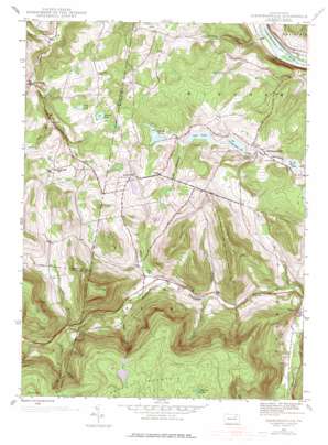
Jenningsville Topo Map Pennsylvania
To zoom in, hover over the map of Jenningsville
USGS Topo Quad 41076e2 - 1:24,000 scale
| Topo Map Name: | Jenningsville |
| USGS Topo Quad ID: | 41076e2 |
| Print Size: | ca. 21 1/4" wide x 27" high |
| Southeast Coordinates: | 41.5° N latitude / 76.125° W longitude |
| Map Center Coordinates: | 41.5625° N latitude / 76.1875° W longitude |
| U.S. State: | PA |
| Filename: | o41076e2.jpg |
| Download Map JPG Image: | Jenningsville topo map 1:24,000 scale |
| Map Type: | Topographic |
| Topo Series: | 7.5´ |
| Map Scale: | 1:24,000 |
| Source of Map Images: | United States Geological Survey (USGS) |
| Alternate Map Versions: |
Jenningsville PA 1945, updated 1956 Download PDF Buy paper map Jenningsville PA 1945, updated 1971 Download PDF Buy paper map Jenningsville PA 1945, updated 1977 Download PDF Buy paper map Jenningsville PA 1945, updated 1977 Download PDF Buy paper map Jenningsville PA 2010 Download PDF Buy paper map Jenningsville PA 2013 Download PDF Buy paper map Jenningsville PA 2016 Download PDF Buy paper map |
1:24,000 Topo Quads surrounding Jenningsville
> Back to 41076e1 at 1:100,000 scale
> Back to 41076a1 at 1:250,000 scale
> Back to U.S. Topo Maps home
Jenningsville topo map: Gazetteer
Jenningsville: Dams
Jennings Pond Dam elevation 312m 1023′Negro Pond Dam elevation 325m 1066′
Sharpe Pond Dam elevation 345m 1131′
Jenningsville: Lakes
Graves Pond elevation 339m 1112′Little Pond elevation 342m 1122′
Sharpe Pond elevation 342m 1122′
Stowell Pond elevation 360m 1181′
Jenningsville: Populated Places
Forkston elevation 238m 780′Hollenback elevation 252m 826′
Jenningsville elevation 314m 1030′
Lovelton elevation 301m 987′
Sciotavale elevation 419m 1374′
Stowell elevation 346m 1135′
Jenningsville: Reservoirs
Chamberlain Pond elevation 323m 1059′Jennings Pond elevation 304m 997′
Negro Pond elevation 324m 1062′
Jenningsville: Ridges
Briskey Mountain elevation 716m 2349′Oak Ridge elevation 568m 1863′
Shingle Ridge elevation 475m 1558′
Jenningsville: Streams
Barnes Brook elevation 357m 1171′Burgess Brook elevation 271m 889′
Catlin Brook elevation 317m 1040′
Coffee Brook elevation 431m 1414′
Miller Brook elevation 297m 974′
Panther Lick Creek elevation 248m 813′
Roaring Run elevation 183m 600′
Rock Cabin Run elevation 285m 935′
Sciota Brook elevation 345m 1131′
Sugar Run elevation 223m 731′
Jenningsville: Summits
Bartlett Mountain elevation 705m 2312′Douglas Hill elevation 596m 1955′
Golden Hill elevation 378m 1240′
Grant Hill elevation 378m 1240′
Round Top elevation 661m 2168′
Jenningsville: Swamps
Big Deer Swamp elevation 694m 2276′Jenningsville: Valleys
Douglas Hollow elevation 274m 898′Farr Hollow elevation 239m 784′
Jenningsville digital topo map on disk
Buy this Jenningsville topo map showing relief, roads, GPS coordinates and other geographical features, as a high-resolution digital map file on DVD:
New York, Vermont, Connecticut & Western Massachusetts
Buy digital topo maps: New York, Vermont, Connecticut & Western Massachusetts


