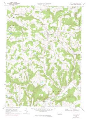
Le Raysville Topo Map Pennsylvania
To zoom in, hover over the map of Le Raysville
USGS Topo Quad 41076g2 - 1:24,000 scale
| Topo Map Name: | Le Raysville |
| USGS Topo Quad ID: | 41076g2 |
| Print Size: | ca. 21 1/4" wide x 27" high |
| Southeast Coordinates: | 41.75° N latitude / 76.125° W longitude |
| Map Center Coordinates: | 41.8125° N latitude / 76.1875° W longitude |
| U.S. State: | PA |
| Filename: | o41076g2.jpg |
| Download Map JPG Image: | Le Raysville topo map 1:24,000 scale |
| Map Type: | Topographic |
| Topo Series: | 7.5´ |
| Map Scale: | 1:24,000 |
| Source of Map Images: | United States Geological Survey (USGS) |
| Alternate Map Versions: |
Le Raysville PA 1967, updated 1971 Download PDF Buy paper map Le Raysville PA 1967, updated 1978 Download PDF Buy paper map Le Raysville PA 2010 Download PDF Buy paper map Le Raysville PA 2013 Download PDF Buy paper map Le Raysville PA 2016 Download PDF Buy paper map |
1:24,000 Topo Quads surrounding Le Raysville
> Back to 41076e1 at 1:100,000 scale
> Back to 41076a1 at 1:250,000 scale
> Back to U.S. Topo Maps home
Le Raysville topo map: Gazetteer
Le Raysville: Airports
Giffin Airport elevation 249m 816′Le Raysville: Dams
Totem Lake Dam elevation 368m 1207′Le Raysville: Lakes
Agnew Pond elevation 378m 1240′Atwoods Pond elevation 443m 1453′
Bert Jayne Pond elevation 409m 1341′
Chillson Pond elevation 385m 1263′
Reeves Pond elevation 378m 1240′
Rockwell Pond elevation 403m 1322′
Smith Pond elevation 403m 1322′
Zion Heights Pond elevation 409m 1341′
Le Raysville: Populated Places
Brushville elevation 335m 1099′East Herrick elevation 388m 1272′
Le Raysville elevation 425m 1394′
Neath elevation 347m 1138′
Prattville elevation 390m 1279′
Stevensville elevation 262m 859′
Stone House Corner elevation 313m 1026′
Wells Hollow elevation 352m 1154′
Zion Heights elevation 415m 1361′
Le Raysville: Post Offices
Pike Post Office (historical) elevation 271m 889′Le Raysville: Reservoirs
Leisure Lakes elevation 385m 1263′Phillips Pond elevation 443m 1453′
Totem Lake elevation 368m 1207′
Le Raysville: Streams
Beaver Creek elevation 351m 1151′Ford Street Creek elevation 311m 1020′
Mill Creek elevation 263m 862′
Rockwell Creek elevation 244m 800′
Ross Creek elevation 246m 807′
Williams Creek elevation 322m 1056′
Wolf Creek elevation 251m 823′
Le Raysville: Valleys
Jackson Valley elevation 328m 1076′Le Raysville digital topo map on disk
Buy this Le Raysville topo map showing relief, roads, GPS coordinates and other geographical features, as a high-resolution digital map file on DVD:
New York, Vermont, Connecticut & Western Massachusetts
Buy digital topo maps: New York, Vermont, Connecticut & Western Massachusetts


